Why it is self hostable first?
Prompts and tool payloads are usually the most sensitive material a team handles. Customer messages, internal documents, credentials passed to tools.
SentryLLM sits in front of that context and reads it first. It flags prompt injection, jailbreak framing, exfiltration attempts and behaviour that has drifted from your own baseline, then blocks, redacts or simply records depending on what you have told it to do.
SentryLLM watches your AI systems in production, detecting prompt injection, jailbreaks, data exfiltration attempts and anomalous behaviour before they cause damage. Every verdict comes with the exact span that triggered it, so you can see what happened rather than guess.
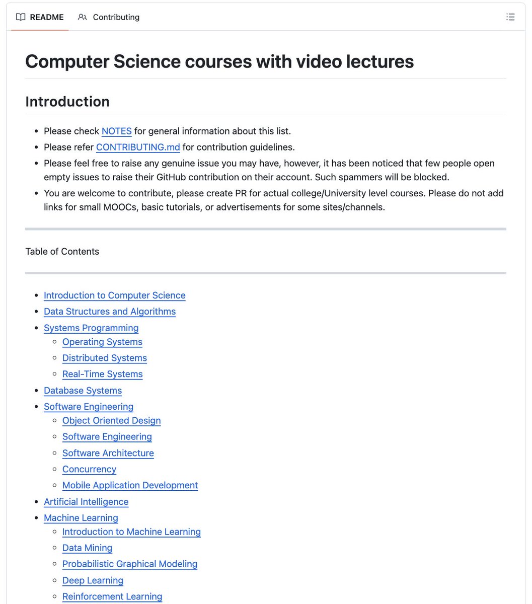
🚨BREAKING: Someone compiled every CS course from MIT, Stanford, Harvard, CMU and Berkeley in one place.
You can learn:
- Algorithms, OS, Distributed Systems, ML, AI
- Deep Learning, Computer Vision, NLP, LLMs
- Security, Databases, Quantum Computing
- 500+ courses with full video lectures
70.3K stars. 100% Opensource.
Found a MQTT explorer tool today!
📡 LazyMQTT — A TUI client for browsing, inspecting & publishing MQTT messages
💯 Live topic trees, message history, JSON/XML/Protobuf views, alerts, traffic analytics & more
🦀 Written in Rust & built with @ratatui_rs
⭐ GitHub: https://t.co/VjQtWGTkFO
#rustlang #ratatui #tui #mqtt #iot #terminal #opensource
someone built an OPENSOURCE MILITARY RADAR that tracks multiple targets up to 20km away
its called AERIS-10, full github repo schematics, PCB layouts, FPGA code, python GUI, everything under MIT license
commercial phased array radar starts at $250,000. military surplus is $10,000-50,000 but its decades old analog junk with no electronic beam steering
this does electronic beam steering at 10.5GHz, pulse compression, doppler processing, multi-target tracking on a real time map
two versions: 3km range with patch antenna array, 20km range with 32x16 slotted waveguide array and GaN AMPLIFIERS
custom frequency synthesizer, 16 front-end chips, FPGA doing all signal processing, GPS and IMU for ACCURATE target coordinates when the platform moves
all gerber files included so you can order the PCBs and build it yourself
one person built what defense contractors charge a quarter MILLION for and open sourced it
[OpenSource - AI Agent Loops & Automation]
Everyone talks about autonomous AI loops, but most agent workflows break down or get stuck in production. 🛑
loop-library by Loopany is an open-source collection of battle-tested AI agent loops engineered to deliver actual, real-world results.
Here is how these ready-to-use agent prompts upgrade your automation stack. 🧵👇
1/4
Amazon Ring died on May 22, 2026.
It just doesn't know yet.
One dad in Nashville, Tennessee built a free MIT-licensed app that watches your driveway, your porch, your baby monitor, your garage.
No cloud. No subscription. No cop ever gets the footage.
32,057 stars. 3,103 forks. Pushed today.
Here is the wildest part:
You: "How much is Ring Protect Pro?"
Ring: "$19.99 a month. $199.99 a year. Per house."
You: "How much is Google Home Premium Advanced?"
Google: "$20 a month. $200 a year. Per house."
You: "What do I get?"
Both: "We store your footage in our cloud. Ring already paid the FTC $5.8 million in 2023 for letting employees and contractors watch your videos without your consent. Google just raised Nest prices again in 2025."
You: "What does Frigate cost?"
Blake Blackshear: "Nothing. It runs on the Raspberry Pi already on your shelf. The footage never leaves your house. I have a day job."
Ring sells the camera. Then sells your fear back to you, monthly, forever.
Frigate sells nothing. Because Blake isn't selling.
He's a dad with 1,267 followers who got tired of Amazon owning his front door.
100% Opensource.
100% Local.
100% Yours.
The smart camera industry made one bad assumption.
That you'd keep paying rent on a camera you already bought.
That assumption just died in Nashville.
I love this opensource project!
Someone just put a 28.9M parameter AI model on an ESP32-S3.
A chip that costs only a few dollars.
No cloud.
No API.
No internet.
It runs locally at ~9.5 tokens/s and can generate stories on a tiny screen.
This changes the way we think about AI hardware.
The next generation of AI toys, robots, and IoT devices may not need the cloud at all.
Small chips are getting smarter. 🤖
https://t.co/HT6wH6wdSx
Introducing Long Horizon Agent Harness.
Open-source reference built with Agent Development Kit for you to lift the patterns you like into production.
Cross-session memory, per-user sandbox, sub-agents, guardrails, and a nightly pass where the agent dreams.
100% Opensource.
GeoLibre v2.3.0 is here!
GeoLibre is a free and open-source, lightweight, cloud-native GIS platform for visualizing, exploring, and analyzing geospatial data. It runs everywhere you do, in the web browser, on the desktop, on mobile, and inside Jupyter notebooks, all while keeping your data local and private.
This release brings a legend that writes itself from your symbology, a new GeoLens catalog browser, and 200+ GeoLibre Rust geoprocessing tools running entirely in the browser.
What's new in v2.3.0
- Automatic on-map Legend: the legend builds itself from your visible layers, with class rows for graduated, categorized, rule-based, and expression styling, gradient bars for heatmaps and raster colormaps, and land-cover labels from a Raster Attribute Table. Rename, hide, reorder, or add your own entries, and it saves with the project.
- Symbology swatches in the Layers panel: every row shows a dot, line, square, or image glyph in the layer's own color, so a tall layer stack reads at a glance.
- GeoLens catalog browser: connect to a self-hosted GeoLens server, search its catalog, and add datasets as vector tiles, GeoJSON, or rendered raster tiles.
- Emerging Hot Spot Analysis: build a space-time cube from timestamped points and classify every cell as a new, intensifying, persistent, diminishing, sporadic, oscillating, or historical hot or cold spot, all client side.
- Mosaic time series: the Time Slider now steps through MosaicJSON and STAC collections of many COGs per date, on either a GPU or a WASM rendering engine.
- Copy and paste layer styles: give a whole set of layers one consistent look without restyling each in turn.
- Shareable tool links: deep-link any Whitebox tool with a ?tool= URL that opens the dialog preselected and pre-fills the form, with a Copy link button to build it for you.
- Smarter data loading: pick which layers to load from a multi-layer GeoPackage, import CSVs whose coordinates are in any projected CRS, and read a raster's real CRS, pixel size, and extent from the metadata dialog.
- Multiple AI profiles: define several provider, model, and credential setups, pick a default, and switch between them from the assistant panel.
Try it out
- Launch GeoLibre Web: https://t.co/8gMtkVtfnm
- GitHub: https://t.co/VXq8c1o2Nd
- Documentation: https://t.co/7VA2AQoCUc
- Release notes: https://t.co/cf3fXneeh6
#GIS #Geospatial #OpenSource #RemoteSensing #MapLibre #GeoLibre
Meet OpenArm—an open-source, dual-arm Physical AI robot. 🤖🤖
By combining physical robotic hardware with AI-driven intelligence, platforms like OpenArm are helping researchers explore how AI can perceive, reason, and act in the physical world.
Open-source robotics could be a major catalyst for Physical AI development.
#OpenArm #PhysicalAI #OpenSource #Robotics #AI
Berkat JEPE di #PANDAWA88, om Andre langsung di goyang LC idaman boyyy 😍😍
𝐏𝐚𝐬𝐭𝐢 𝐄𝐧𝐚𝐤 : https://t.co/OXbe3w1USJ
𝐑𝐓𝐏 𝐄𝐧𝐚𝐤 : https://t.co/iewlqst36S
𝐃𝐢𝐚𝐦, 𝐓𝐞𝐧𝐚𝐧𝐠, 𝐌𝐄𝐍𝐀𝐀𝐍𝐆𝐆.. ✅