Down tree on Louise Street near Wilson park in Fayetteville. Owner of the house said it fell around midnight due to the high winds! @weatherdan@KNWAFOX24@RugsWX#arwx
Our tornado risk has been upgraded for Friday evening…
If you missed my morning update, thunderstorms are likely again tomorrow evening across Arkansas.
Especially western sections of the state. We are uncertain on just how many storms will actually form.
If thunderstorms are able to organize, they could rotate. I would be surprised if we escaped tomorrow evening without a couple of tornado warnings
We’re holding tight on the “medium risk” category on the Arkansas Weather Network scale.
This is not a high risk for tornadoes, but higher than last night (which was VERY low).
The forecast will likely change a bunch before tomorrow evening, we know how that goes.
Stay tuned, we got this!
——
Update sponsored by Arkansas Storm Shelters, call them today for a free quote on your shelter (479-967-7233).
Want to see multiple downbursts in motion? Check out this time-lapse from our Posy Mountain WeatherBug camera overlooking Beaver Lake! This storm was responsible for wind damage causing thousands of power outages from damaging winds & large hail. AMAZING @NWSTulsa !!! #ARwx
This was crossing I49 near exit 69 this morning around 7:30am. Funnel cloud? Tornado? @weatherdan. Died out as it got off the interstate but left a lot of debris (sticks and branches) on the road.
Viewer in east Springfield sent this video of possible rotation earlier this evening. Tornado threat has cleared for Springfield. Confirmed tornadoes touched down near Halltown and Fair Grove.
New to tornado forecasting?
In my experience, it can take a while to figure out the best resources to make a part of your forecasting routine.
So, in case it's helpful, here is a list of sites that I've found useful:
1/7
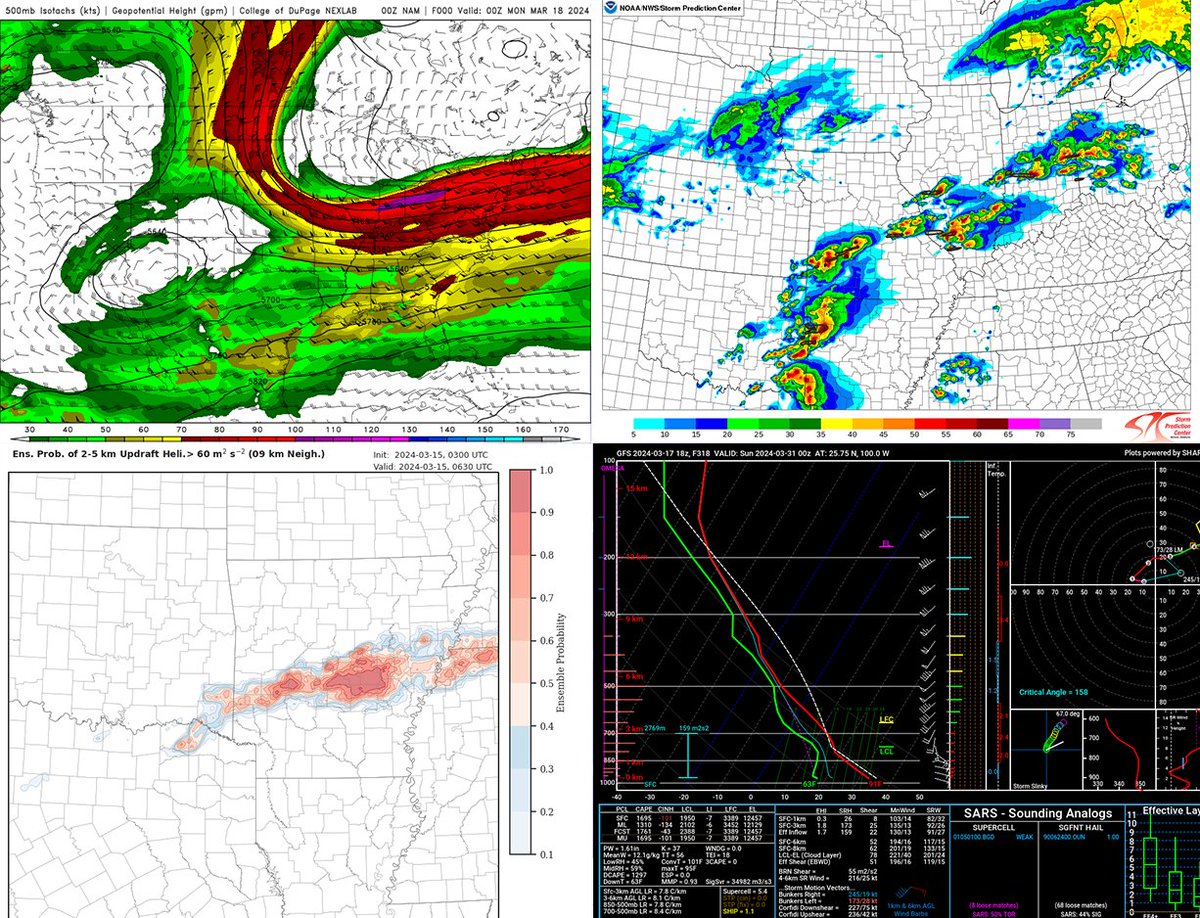
We are thinking a bimodal event today but with separate jet streaks with strong #tornado potential from central IL into northern IN and also eastern OK, western AR, extreme northeast Texas this late afternoon and evening. Could also happen in between in MO! Gorilla hail likely
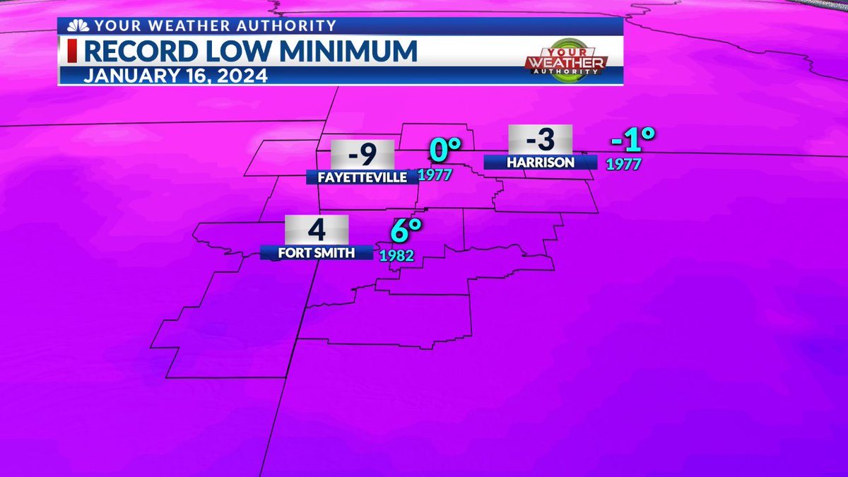
NEW RECORDS: We crushed some daily record lows in our area this morning! The official temperatures were even colder than what shows up on this graphic believe it or not!
Fayetteville (Drake Field) recorded a temperature of -10°, which destroyed the previous record of 0° set in 1977 & 1997!
Fort Smith recorded a temperature of 3°, beating out the previous record of 6° set in 1982!
Finally, Harrison got all the way down to -3°, which crushed the record low of -1° set in 1977!
Hope everyone is staying warm and safe across the area! We have much warmer temperatures coming up next week, so hang on for a little while longer! #ARwx #NWANews
Hi weather nerds!🌨️🌤️🌪️
- I’m applying to CSU AS masters program next year, but I need to beef up my resume. Any advice for a young wanna be meteorologists applying to a competitive program?
- I have an insta account for NWA Weather! It’d be cool if you gave it a follow! #arwx
[9:31 am - 1/15/24] It's been a record setting morning for both Tulsa and Fayetteville (Drake Field), as both dropped to -3 degrees. Tulsa's previous record low of 0 predates statehood (1905!), while the previous Drake Field record of 2 was set in 1972. #okwx#arwx