Interested in meteorology! I try my best to give good info, but if I do mess up let me know! I hope to go to OU and pursue my dreams in the weather industry. 🐈
In the red area is where storms are possible with heavy rain. hail up to ping pong size, and winds up to 60mph. While the magenta area is where a few tornados are possible. But heavy flooding rains, hail up-to 2 inch, and wind up-to 70mph are the most likely threats!
Just a reminder is that my stuff isn't official! I am just someone who is very passionate about meteorology and hope to pursue a mereological degree in the future. Here is a link to the WPC. Let me know if you have any questions!
https://t.co/rvowot8coA
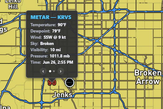
Looking across Oklahoma for todays severe threat shows that the main threats will be large hail up to 2 inch, and winds up to 70mph. Right now dew points are around 90/79, and it feels horrible, but this has allowed for sfc. cape values of 5500, and mixed around 3500.
In the red area is where storms are possible with heavy rain. hail up to ping pong size, and winds up to 60mph. While the magenta area is where a few tornados are possible. But heavy flooding rains, hail up-to 2 inch, and wind up-to 70mph are the most likely threats!
Watching for possible initiation along the boundary. Also the storms in Tulsa should move out and allow for some heating again, although the have definitely left a weak cold pool in there wake.