The idea was brilliant. The execution was catastrophic.
Allied planners knew that the men hitting the beaches of Normandy would be cut apart without armor support in those first critical minutes. The solution was the DD tank. The Duplex Drive Sherman. A standard 33-ton Sherman tank fitted with a collapsible canvas flotation screen and two small propellers bolted to the rear. Raise the screen, drop into the water, swim to shore, lower the screen, start shooting. Tanks arriving with the first wave, ahead of the infantry, suppressing German positions before the ramps even dropped.
The concept worked perfectly in testing. The designers had one requirement: waves no higher than one foot.
On the morning of June 6th, 1944, the waves off Omaha Beach were six feet high.
Nobody stopped the launch.
At 5:40 AM, the 741st Tank Battalion began dropping their DD tanks into the English Channel, six thousand yards from shore. More than three miles of open water, in seas that were six times rougher than the tanks were designed to handle. The first tank hit the water. The canvas screen, designed to hold the weight of a Sherman afloat, was immediately overwhelmed. Waves crashed over the top. Water flooded in. The tank went down.
Then another. Then another.
The canvas screens collapsed like paper bags in the swell. Tanks that had been designed to float became 33-ton anchors the moment they hit the water. Crews inside had seconds. Some got out through the hatches. Many did not. The tanks took them straight to the bottom of the English Channel.
Some crews managed to get a radio signal out as their tank went under, warning the following units not to launch. The warnings either did not get through or came too late.
29 DD tanks were launched by the 741st Tank Battalion that morning. 27 sank before reaching the beach. The entire left flank of Omaha Beach, where the 1st Infantry Division was assaulting, had five tanks to support it. Five. Against fortified German positions housing hundreds of machine guns, 88mm guns, and mortars zeroed on every inch of that sand.
The infantry arrived first. Alone.
What happened next at Omaha Beach, the 2,400 casualties, the slaughter in the first ten minutes, the near-total destruction of Company A, is inseparable from the loss of those tanks. They were supposed to be there. They were supposed to be firing at German positions while the ramps were still closed. Instead they were on the bottom of the Channel with their crews.
The story of the 743rd Tank Battalion makes it worse.
The 743rd was assigned to the western sector of Omaha Beach. Their LCT flotilla commander looked at the sea conditions that morning, looked at the waves, and made a different decision. He refused to launch his tanks into the water. Instead he drove his LCTs directly onto the beach and dropped the ramps in the shallows. The tanks rolled off onto sand.
Nine tanks were knocked out by German fire during the assault. But they were there. They were fighting. The infantry had armor.
At Utah Beach, the sea was calmer, protected from the prevailing winds. 28 of 32 DD tanks launched there made it ashore. The infantry had support. Utah Beach cost 197 casualties. Omaha cost 2,400.
The sunken tanks of the 741st Tank Battalion still lie on the bottom of the English Channel off Omaha Beach. They have never been raised. Divers have visited them. Inside some of the wrecks, they found what they expected.
They are still there today, 82 years later, three miles off the coast of Normandy, on the bottom of the sea.
Today is June 6th.
Remember them.
Timelapse of the Allied advance from D-Day on 6th June 1944, to VE-Day on 8th May 1945. The largest seaborne invasion in history and the liberation of Western Europe.
USA - Blue
UK - Orange
Canada - Red
Germany - Black
On the morning of June 4, 1942, a US Navy pilot strapped into his dive bomber, took a breath from his oxygen canister, and inhaled caustic soda fumes.
The canister was defective. His lungs were already burning.
He flew the mission anyway.
By sunset, Dick Best had done something no pilot in history has done before or since. And he paid for it with everything.
Best was 31, commander of Bombing Squadron Six aboard USS Enterprise. Six months after Pearl Harbor, America was losing the Pacific. Four Japanese carriers, the same fleet that had attacked Hawaii, were steaming toward Midway to finish the US Navy for good.
His air group launched that morning and found nothing but empty ocean. Fuel running low, the formation was minutes from turning back when group commander Wade McClusky spotted a lone Japanese destroyer racing north at full speed. He made a gut call: follow it.
The destroyer led them straight to the entire Japanese fleet.
Then came the mistake that almost ruined everything. Doctrine said McClusky's group should take the far carrier and Best's squadron the near one. Instead, nearly all 30 dive bombers poured down on the same ship, Kaga.
Best watched his own squadron dive past him onto the wrong target. So he pulled out, signaled his two wingmen, and went after the other carrier with 3 planes instead of 15.
That carrier was Akagi. The flagship. The ship that had launched the attack on Pearl Harbor.
Best rolled into his dive through anti-aircraft fire and put a 1,000 lb bomb through the flight deck near the midship elevator. It exploded in the hangar below, packed with fueled and armed torpedo planes. The blast set off a chain reaction that no one aboard could stop.
One bomb. One hit. Akagi was finished.
In roughly five minutes that morning, three of Japan's four carriers were burning wrecks. Historians call it the most decisive five minutes of the entire war.
But one carrier was left. That afternoon, coughing and getting worse, Best climbed back into his cockpit and flew again. His squadron found Hiryu at dusk and sent her to the bottom too.
Two carriers in one day. The only pilot ever to do it.
That night, Best was coughing blood. The caustic fumes had activated latent tuberculosis in his ruined lungs. He spent 32 months in hospitals and never flew again.
June 4, 1942 was his last flight.
Japan never recovered. The empire that had been undefeated for centuries lost the initiative in a single morning and spent the rest of the war in retreat.
And the most consequential single bomb dropped before Hiroshima was delivered by a man who was slowly suffocating as he aimed it.
84 years ago today.
🇺🇸July 10, 1945 – The Northrop P-61B “Black Widow” #42-39445 of the 550th Night Fighter Squadron, based in Hollandia, New Guinea, took off on what was supposed to be a “familiarization flight.”
Without any authorization, the pilot (*) takes three passengers on board, including a 20-year-old WAAC nurse (!). The flight ends at 5,000 feet on the slopes of Mount “Cyclops,” just a few miles from the departure airfield. Everyone on board survives with minor injuries, and the aircraft sustains heavy damage.
This aircraft was recovered in 1989 and has been restored at the Mid-Atlantic Air Museum in Reading, Pennsylvania, under the registration N550NF.
➡️https://t.co/X0Ctm7Yvqr
🎬Dan's Cool Videos
➡️https://t.co/OMGrt7KVWv
A rare insight into the working of the radio proximity fuze developed and used during World War II, 1944 with key contributions from General Electric.
Inside the cutaway, the system reveals a miniature radar set powered by a fragile glass electrolyte ampoule that shattered under launch acceleration, activating the battery and bringing the fuze online in flight. Once armed, it emitted a continuous radio signal and measured reflections from nearby targets, triggering detonation when an aircraft entered roughly the 20 to 70 foot range, where fragmentation effects were most effective.
It costed about 18 to 20 dollars per unit in 1945 at wartime production scale, that still feels strikingly advanced even 75+ years later.
Video Source:- Inert Ordnance
One of the challenges that makes mapping from Second World War unit war diaries particularly difficult is the mapping system itself, specifically the coordinate grids and map projections used at the time.
The British relied on several different map projection systems, each built on geodetic datums that were, by modern standards, imprecise. For northwest Europe, the two most relevant are Lambert Zone I, based on the Nouvelle Triangulation Française (NTF) datum and the Clarke 1880 ellipsoid, and Nord de Guerre, an older WWI-era grid based on the Ancienne Triangulation Française (ATF) datum and the Plessis 1817 ellipsoid. By 1944, Nord de Guerre was technically obsolete, but it still appeared as marginal reference ticks on many British-issued map sheets. These datums were derived from earlier triangulation surveys and predated the computational methods that would later allow for globally consistent, satellite-verified reference systems.
Geodesy as a discipline was still maturing, and without computers, producing and correcting large-scale surveys was slow, laborious work, made harder by the fact that a war was actively being fought. The practical consequence for a theatre like Normandy was that available map coverage relied on conical projections, specifically Lambert Conformal Conic, rather than the narrower strip-by-strip Transverse Mercator projection that underpins the modern Military Grid Reference System (MGRS). Transverse Mercator projections perform well over narrow north-south bands but distort rapidly as you move east or west. Lambert Conic projections handle wider east-west extents better, which is why they were preferred for covering broad operational theatres. The tradeoff is that both introduce distortion of different kinds depending on where you are on the sheet, and that distortion was baked into every map issued to every unit.
Layer on top of that the generalisation inherent in the most commonly available wartime maps, the GSGS 1:100,000 series. At that scale, features must be simplified: roads straightened, villages approximated, contours smoothed and errors compounded. In practice, positional inaccuracy across these sheets typically falls in the range of 100 to 200 metres, with worse outliers possible depending on the area and the source survey data. By modern standards that is significant. GPS-guided munitions rely on sub-metre accuracy, and calling close artillery fire with that margin of error would be genuinely hazardous to friendly troops. In the Second World War, those errors were real and unavoidable, and commanders and surveyors simply had to account for them operationally.
When we mapped Project '44, we manually georeferenced each GSGS map sheet and stitched them together, tying the sheets to known, identifiable features on the ground. Done carefully, this process keeps positional accuracy near the lower end of that 100 to 200 metre range, but it cannot push below it. The original datum and projection errors, the generalisation of the source maps, and the inevitable human error in the georeferencing process all combine in ways that cannot be fully eliminated. There is a floor, and that floor is set by the accuracy of the original surveys.
Over the last several days I have been working on a new approach to reduce that residual uncertainty and speed up the mapping workflow. It is a system of systems that brings together three reference layers in one interface.
The first is the wartime grid systems, specifically the coordinate grids actually used in the war diaries, enabling direct input and plotting of grid references as they appear in the source documents. The second is the georeferenced GSGS basemaps, the original wartime maps georeferenced to a modern coordinate system, so a plotted grid reference can be visually cross-checked against the map the unit itself would have been reading. The third is a modern accurate basemap, a contemporary mapping layer using current satellite-derived data, for ground truth comparison.
The idea is convergence across three independent references. Where all three agree, you have high confidence. Where they diverge, a human mapper can apply contextual judgment, drawing on terrain, road networks, and the unit narrative, to make the call on where the position actually was. The goal is faster, more efficient mapping without sacrificing interpretive rigour. Rather than automating the decision, the tool gives the mapper the best possible information to make an informed judgment about where a unit was and what they were doing.
84 years ago today, two fleets sailed toward each other across the Coral Sea and never once laid eyes on the enemy they were about to destroy.
May 4, 1942. The Battle of the Coral Sea begins.
It would change naval warfare forever.
For the first time in human history, warships fought a battle without ever seeing each other. Every shot fired came from an aircraft launched off a carrier deck. The age of the battleship was quietly dying, and almost nobody on either bridge realized it yet.
The setup: Japan had just spent five months running the table in the Pacific. Pearl Harbor. Singapore. The Philippines. Rabaul. By late April they wanted Port Moresby in New Guinea, the last Allied foothold guarding Australia’s northern approaches. Take it, and Australia gets cut off from America.
The Allies knew they were coming. American codebreakers were reading roughly 85 percent of Japanese naval traffic. Coastwatchers hidden in the jungles of New Guinea were tracking aircraft movements in real time. Admiral Chester Nimitz sent two carriers, Lexington and Yorktown, to wait in the Coral Sea.
May 4. Yorktown’s aircraft strike the Japanese landing force at Tulagi at dawn. A destroyer goes down. Minesweepers burn. The Japanese suddenly realize American carriers are here, and they have no idea where.
What followed was four days of pure naval chaos. Both sides launched massive strikes at the wrong targets. Americans sank an oiler and a destroyer they thought were carriers. Japanese pilots, returning at dusk on May 8, mistook Yorktown for one of their own and tried to land on her deck. She opened fire.
May 7: American dive bombers find the light carrier Shoho. In 25 minutes she absorbs seven torpedoes and thirteen bombs. Lieutenant Commander Robert Dixon radios the most famous transmission of the early Pacific war:
“Scratch one flattop.”
May 8: The big one. Lexington takes two torpedoes and two bombs. Damage control thinks they have her saved. Then leaking aviation fuel ignites belowdecks. Massive explosions tear through her. The crew abandons ship. 92 percent are rescued. A destroyer puts five torpedoes into her to send her down.
Tactically, Japan won. They sank a fleet carrier, a destroyer, and an oiler. They lost only the light carrier Shoho.
Strategically, it was a disaster for them. The Port Moresby invasion was called off. Australia stayed in the war. And both Shokaku and Zuikaku, two of Japan’s six fleet carriers, were knocked out of action.
One month later, those two missing carriers would have been at Midway. They weren’t.
Coral Sea is the battle nobody talks about because Midway followed it. But without Coral Sea, there is no Midway. Without Midway, the Pacific war looks completely different.
The first carrier battle in history. Fought blind. Won by the side that lost more ships.
84 years ago today.
This day in 1944, Sgt Norman Jackson crawled onto the wing of his burning Lancaster bomber at 20,000 ft, attempting to extinguish a fire and save his crew.
He fell (with damaged parachute) after a German night fighter attacked. Survived, captured, and earned the Victoria Cross in 1945. #WW2
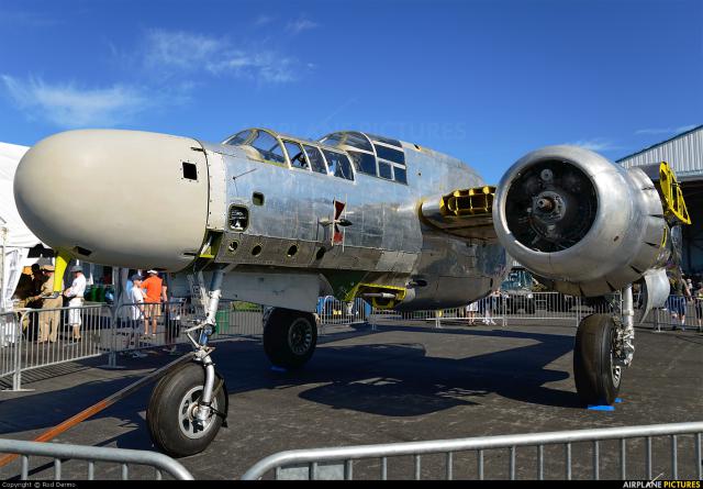
Austin approach onboard @MillionAir_FBOs fully-restored A-26C Invader from World War 2!
Fly any aircraft with declassified weapons & avionics programming for anyone in the family:
https://t.co/6ZFvSx61fX 🛍️
El rugido de los motores #Merlin durante el vuelo inaugural del restaurado De Havilland Mosquito FB.Mk40 con matrícula NZ2308, el 18 de marzo de 2024 en Auckland, Nueva Zelanda.
Este es el cuarto #Mosquito restaurado por la compañía 🇳🇿 #Avspecs#Warbird
Hedonismo aeronáutico
#Messerschmitt Bf-109G-4 despegando entre la neblina con la helice formando vórtices alrededor de él
Pertenece al Military Aviation Museum y el 📹 a Ferenc Poka
Luce como el avión de Hptm. Klaus Quaet-Faslem GruppenKommandeur del I/JG3 “Udet”
#Warbird