Weather enthusiast and leader of Alabama Weather Prediction (@AlabamaWXPred). Aiming to prepare, not to scare. Focused on severe weather for northern Alabama.
TweetDeck (XPro) is now requiring premium. I am not paying for premium. I'm not going to be on Twitter as much except for when severe weather is active. I suggest joining our Team's Discord server for communicating https://t.co/8N0xjrhMVq
A STRONG THUNDERSTORM WILL IMPACT NORTHEASTERN JACKSON AND NORTHEASTERN DEKALB COUNTIES THROUGH 100 PM CDT [wind: 40 MPH, hail: 0.75 IN] https://t.co/MoGMZKNAcs
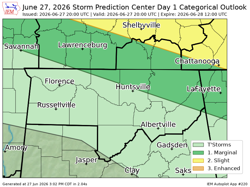
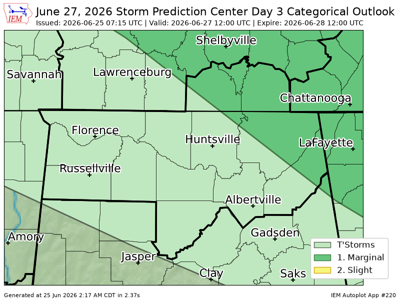
12:36pm CDT #SPC Day2 Outlook Slight Risk: ACROSS PORTIONS OF THE CENTRAL/SOUTHERN HIGH PLAINS INTO SOUTHERN KANSAS AND NORTHERN OKLAHOMA AND INTO THE OZARKS https://t.co/Y1WiOd8m1i
HUN continues Severe Thunderstorm Warning [tornado: POSSIBLE, wind: 60 MPH (RADAR INDICATED), hail: <.75 IN (RADAR INDICATED)] for DeKalb, Jackson [AL] till 5:15 PM CDT https://t.co/oVFqm7l2vg
HUN issues Severe Thunderstorm Warning [tornado: POSSIBLE, damage threat: CONSIDERABLE, wind: 70 MPH (RADAR INDICATED), hail: <.75 IN (RADAR INDICATED)] for DeKalb, Jackson [AL] till 5:15 PM CDT https://t.co/YG2mQy0LbB
HUN updates Severe Thunderstorm Warning [wind: 60 MPH (RADAR INDICATED), hail: <.75 IN (RADAR INDICATED)] (cancels Lincoln [TN], continues DeKalb, Jackson, Madison [AL]) till 4:45 PM CDT https://t.co/oIGj8gRC2S


![alstormtracker's tweet photo. A STRONG THUNDERSTORM WILL IMPACT NORTHEASTERN JACKSON AND NORTHEASTERN DEKALB COUNTIES THROUGH 100 PM CDT [wind: 40 MPH, hail: 0.75 IN] https://t.co/MoGMZKNAcs https://t.co/cdUMk7cUWn](https://pbs.twimg.com/media/HL1lTdQX0AAOt8o.jpg)


![alstormtracker's tweet photo. A STRONG THUNDERSTORM WILL IMPACT SOUTHEASTERN MARSHALL AND SOUTHERN DEKALB COUNTIES THROUGH 600 PM CDT [wind: 50 MPH, hail: 0.00 IN] https://t.co/D0njXONJrd https://t.co/Hn90PAr9Mh](https://pbs.twimg.com/media/HLc1qO3XkAAPUSk.jpg)
![alstormtracker's tweet photo. HUN continues Severe Thunderstorm Warning [tornado: POSSIBLE, wind: 60 MPH (RADAR INDICATED), hail: <.75 IN (RADAR INDICATED)] for DeKalb, Jackson [AL] till 5:15 PM CDT https://t.co/oVFqm7l2vg https://t.co/TbenIvMtLh](https://pbs.twimg.com/media/HLc0S-YXsAA3Gdd.png)
![alstormtracker's tweet photo. HUN cancels Tornado Warning for DeKalb, Jackson [AL] https://t.co/XIDGJv5cPH https://t.co/jiarTZLo7H](https://pbs.twimg.com/media/HLcz-x1XMAE0qBQ.png)
![alstormtracker's tweet photo. HUN continues Tornado Warning [tornado: RADAR INDICATED, hail: <.75 IN] for DeKalb, Jackson [AL] till 5:30 PM CDT https://t.co/tI3LKunzSr https://t.co/XVrvpQbCck](https://pbs.twimg.com/media/HLcxZDCWgAANXTy.png)
![alstormtracker's tweet photo. HUN expires Tornado Warning for Jackson [AL] and Franklin [TN] https://t.co/oVPGA8jiEI https://t.co/gApibVOlbA](https://pbs.twimg.com/media/HLcxRrFWoAAr6Ey.png)
![alstormtracker's tweet photo. HUN expires Severe Thunderstorm Warning for DeKalb, Jackson, Madison [AL] https://t.co/dcOVnE7AHN https://t.co/2L8PAHnJiX](https://pbs.twimg.com/media/HLcvnPgWcAAdFXV.png)
![alstormtracker's tweet photo. HUN issues Severe Thunderstorm Warning [tornado: POSSIBLE, damage threat: CONSIDERABLE, wind: 70 MPH (RADAR INDICATED), hail: <.75 IN (RADAR INDICATED)] for DeKalb, Jackson [AL] till 5:15 PM CDT https://t.co/YG2mQy0LbB https://t.co/b841IhxFFZ](https://pbs.twimg.com/media/HLcvYuLWcAA9eAI.png)
![alstormtracker's tweet photo. HUN issues Tornado Warning [tornado: RADAR INDICATED, hail: <.75 IN] for DeKalb, Jackson [AL] till 5:30 PM CDT https://t.co/PMcfXXuixR https://t.co/XqisRNiSSM](https://pbs.twimg.com/media/HLcuDe1WIAARqF4.png)
![alstormtracker's tweet photo. HUN continues Tornado Warning [tornado: RADAR INDICATED, hail: 0.00 IN] for Jackson [AL] and Franklin [TN] till 5:00 PM CDT https://t.co/XP9eJR1xZR https://t.co/kPUsLgcRGv](https://pbs.twimg.com/media/HLct6zUXMAEau36.png)
![alstormtracker's tweet photo. HUN updates Severe Thunderstorm Warning [wind: 60 MPH (RADAR INDICATED), hail: <.75 IN (RADAR INDICATED)] (cancels Lincoln [TN], continues DeKalb, Jackson, Madison [AL]) till 4:45 PM CDT https://t.co/oIGj8gRC2S https://t.co/XxXlYJd1Dt](https://pbs.twimg.com/media/HLctIMwWYAEwq6Q.png)


