This image helps explain what happened along the Nepal–Tibet border. According to reports, a magnitude 4.4 earthquake on the Tibetan side triggered a massive ice avalanche, which then led to the flash flooding of the Bhotekoshi River in Nepal. Around 1,000 people are missing, and many have been killed.
A Category 5 marine heatwave has been ongoing along the coast of Peru in recent weeks due to El Niño. Water temperatures have reached up to 13°F (7°C) above normal.
Lima, the capital city, recorded a tropical night in the middle of winter on August 14, with a low of 71°F (21.7°C), its warmest August night ever recorded.
This El Niño is in its own league.
BREAKING: Aside from TY #Dolphin, TS #Chan_hom, and the remnants of TD #MaymayPH (#Kujira), two additional tropical disturbances formed in the Western Pacific (WPAC) basin today: Invest #97W and Invest #98W. ⚠️
INVEST 97W
The disturbance is now assessed by the Joint Typhoon Warning Center (JTWC) with a MEDIUM chance of tropical cyclone development within the next 24 hours.
Currently located in the Gulf of Tonkin, west of Hainan Island, the disturbance is in a generally favorable environment for further intensification. Only a few models indicate the potential for the system to reach tropical cyclone threshold, likely due to its proximity to the Chinese mainland and its broad, elongated structure. Models indicate an eastward movement towards the northern South China Sea before the system eventually merges with the upper-level westerlies.
INVEST 98W
A monsoon depression located northwest of the Marianas is currently in a conducive environment for further intensification, with low-to-moderate southwesterly wind shear, robust upper-level westerly flow, warm sea-surface temperatures (SSTs), and high ocean heat content (OHC).
The disturbance is also currently absorbing the remnants of former Tropical Depression #Kujira (PH: #MaymayPH). Model guidance indicates an eastward to southeastward movement over the next three days before turning northeastward as it interacts with Tropical Storm Chan-hom.
Notes:
1. Both of the mentioned disturbances are, so far, UNLIKELY to enter the Philippine Area of Responsibility (PAR).
2. Aside from these systems, another potential disturbance may develop in the same area as Invest 98W within the next five days, according to global model guidance.
📷: Himawari-9 via RAMMB-CIRA
BREAKING: Both @dost_pagasa and the Joint Typhoon Warning Center (JTWC) are now assessing the area of low pressure west of Luzon as having a HIGH chance of tropical cyclone formation within the next 24 hours. ⚠️
The latter has also issued a Tropical Cyclone Formation Alert (TCFA) for the disturbance.
As of 06Z (2 PM, Manila time) August 4, 2026:
PH: Low Pressure Area (LPA 08a)
US: Invest #94W
JP: Tropical Depression
The Japan Meteorological Agency (JMA) predicts that the disturbance will become a tropical storm within the next 12 hours. Once confirmed, it will be assigned the international name #Kujira. Meanwhile, if PAGASA upgrades the system, it will assign the domestic name #MaymayPH.
JMA's forecast track indicates that TD 94W will move eastward to southeastward over the next 36 hours before making landfall in the Ilocos Region between tomorrow evening (August 5) and Thursday morning (August 6).
Note: The JMA and JTWC have been monitoring the disturbance as a single broad system, while PAGASA has been monitoring it as two separate disturbances. The other disturbance is the former Tropical Depression #LuisPH (LPA 07f), which has already dissipated.
📷: Himawari-9 via NRL-Monterey, JMA via WNI, JTWC
UPDATE: The latest model runs indicate a significant change regarding the potential development of a low pressure area (LPA) northeast of Palau, outside the Philippine Area of Responsibility (PAR), within the next six hours.
All global models are now in agreement that this developing disturbance has a possibility to make landfall over Northern-Central Luzon either late Friday (July 24) or early Saturday (July 25).
Regarding intensity, almost all models also indicate that the potential system will reach tropical storm to severe tropical storm intensity during its passage.
If it develops into a tropical cyclone, @dost_pagasa will assign it the domestic name #KiyapoPH. It is also expected to enhance the Southwest Monsoon (#HabagatPH), potentially bringing significant rainfall across much of the country from late this week into next week.
Disclaimer: The forecast scenario may still change as new model guidance becomes available. Please continue to monitor official updates.
📷: Himawari-9 via Weathernerds
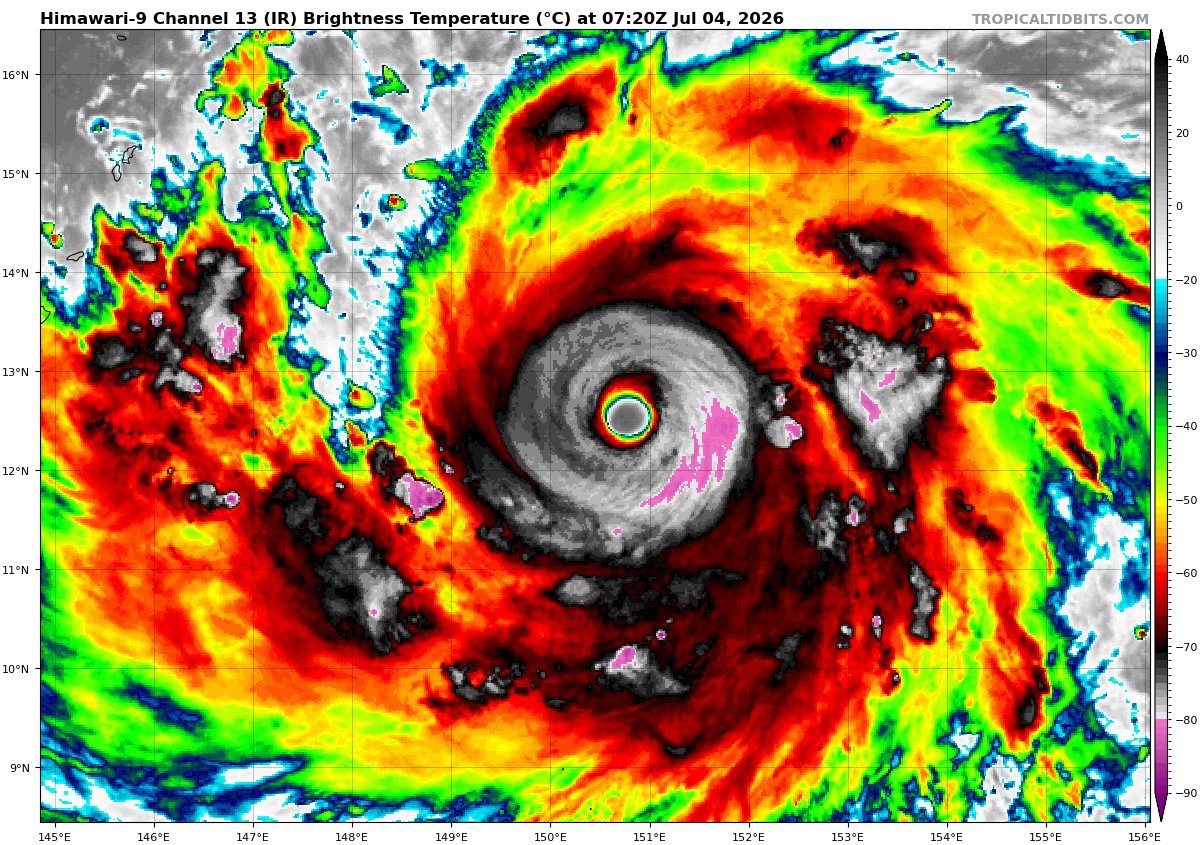
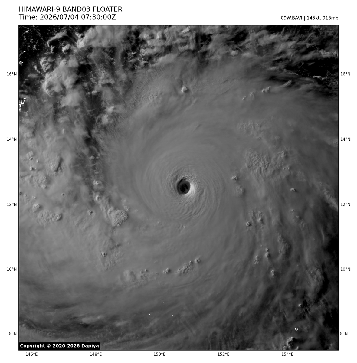
As of 06 UTC today, July 14, 2026, Tropical Storm #Bavi (formerly #IndayPH) has traveled 6,426 kilometers, placing it among the 30 farthest-traveling named tropical cyclones in the Western Pacific (WPAC) basin.
It currently ranks 28th all-time, 7th this century, and is the longest-traveling named storm in the basin since STY Mangkhut (2018).
The Joint Typhoon Warning Center (JTWC) currently assesses the system as a subtropical depression, as it exhibits both tropical and subtropical characteristics while becoming increasingly embedded within the baroclinic zone.
Meanwhile, the Japan Meteorological Agency (JMA) forecasts TS Bavi to make landfall in #NorthKorea tonight.
📷: Himawari-9 via NRL-Monterey
#SciFeature 𝗔𝗧 𝗧𝗛𝗘 𝗖𝗥𝗢𝗦𝗦𝗥𝗢𝗔𝗗𝗦 𝗢𝗙 𝗖𝗬𝗖𝗟𝗢𝗡𝗘𝗦🌀
On average, around 20 tropical cyclones (bagyo) either form within or enter the Philippine Area of Responsibility (PAR) each year, with about 8–9 making landfall, according to PAGASA.
Situated along the western North Pacific, the world's most active tropical cyclone basin, the 𝗣𝗵𝗶𝗹𝗶𝗽𝗽𝗶𝗻𝗲𝘀 𝗶𝘀 𝗮𝗺𝗼𝗻𝗴 𝘁𝗵𝗲 𝗺𝗼𝘀𝘁 𝗰𝘆𝗰𝗹𝗼𝗻𝗲-𝗽𝗿𝗼𝗻𝗲 𝗰𝗼𝘂𝗻𝘁𝗿𝗶𝗲𝘀 𝗼𝗻 𝗘𝗮𝗿𝘁𝗵.
Tropical cyclone activity generally increases from June to November, although storms have been recorded in every month of the year. During the peak season, cyclones typically develop over the western North Pacific and move northwestward, frequently affecting Luzon.
From November to February, however, storms are more likely to take southerly tracks, increasing the chances of crossing the Visayas and even Mindanao.
While Mindanao is affected less often, it is by no means immune. The island has experienced several destructive cyclones, most notably Typhoon Pablo (Bopha), which devastated parts of Mindanao in December 2012.
It is also important to remember that a tropical cyclone does not need to make landfall to cause severe impacts. Its expansive rainbands, strong winds, storm surge, or the southwest monsoon it enhances can trigger widespread flooding, landslides, and coastal inundation hundreds of kilometers away from the storm's center. #NDRM2026 #ResiliencePH #IndayPH #typhoon
USS Liberty survivor Phil Tourney burns the Israeli flag on July 4th and endorses Thomas Massie for president in 2028.
"I burn this evil flag on the Fourth of July."
"I also call out all the Zionist members of Congress and senators."
"You're supposed to fight for this country, not Israel."
Tropical Storms #Mekkhala and #Higos will be joining forces as they move north-eastwards bringing rainfall totals of 300-400mm across parts of Japan at the weekend.
Ocean temperatures in the equatorial Pacific are already exceeding or approaching strong El Niño levels.
All Niño regions are record warm except for Niño 1+2, which was warmer only at this time in 1983.
These are huge anomalies for this time of year.
“My only daughter, my flower… We slept on the same pillow side by side. She’s gone. Why?”
🚨HEARTBREAKING : A grieving mother bids farewell to her only child, 17 year old Raghd Ashour, who was killed in an Israeli airstrike on Gaza City shortly after returning from her final high school exam.
Her father had already been killed earlier in the war.
What has happened at the #2026WorldCup over the last 48 hours:
• Swiss footballer Embolo's visa was put under review and he was only able to join his team days later.
• Iraqi national team player Aymen Hussein was held for questioning for nearly 7 hours upon entering the United States.
• The Iranian national team spent days dealing with visa procedures at the U.S. Consulate in Türkiye. The U.S. only allowed them entry on match days. Fifteen members of the delegation were denied visas.
• Omar Abdulkadir Artan, named CAF's Best African Referee of 2025, was denied a visa. Despite travelling to the U.S. with a diplomatic passport, he was refused entry and sent back. FIFA announced that he will not be able to officiate at the tournament.
• The South African national team arrived in the United States much later than planned because part of the delegation was not granted visas.
• Members of the Senegal national team staff were forced to remove their shoes and subjected to lengthy searches, sparking accusations of racism.
• The Uzbekistan national team was searched with bomb-sniffing dogs and the footage went viral in international media.
• Some Scottish supporters, despite being eligible to enter the U.S. visa-free under the ESTA programme, had their travel authorisations revoked just days before departure.
• Many supporters who had already bought tickets and booked accommodation had their visa applications rejected, resulting in financial losses.
🇮🇷 NEW: Dr. Alireza Zarei, Mathematics Professor and Head of IT Center at Sharif University of Technology in Tehran, holds his ‘Randomized Algorithms’ class for his students in his destroyed office
‘I won’t leave this place, this is our university. They can destroy the building but not the spirit.’
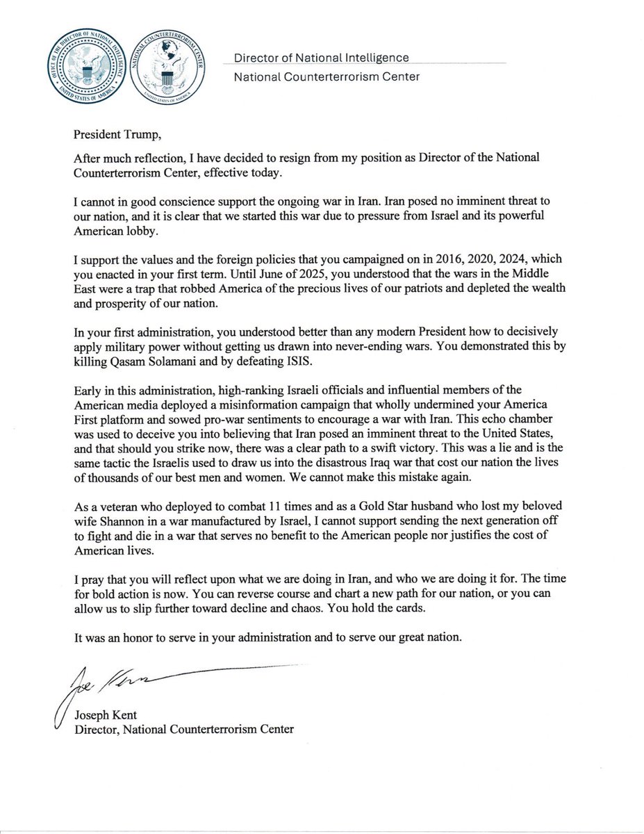
After much reflection, I have decided to resign from my position as Director of the National Counterterrorism Center, effective today.
I cannot in good conscience support the ongoing war in Iran. Iran posed no imminent threat to our nation, and it is clear that we started this war due to pressure from Israel and its powerful American lobby.
It has been an honor serving under @POTUS and @DNIGabbard and leading the professionals at NCTC.
May God bless America.
⚡️🇺🇸BREAKING: Geolocation and evidence contradicts Trump’s claim of Iran striking the school (TRUMP LIED).
New footage shows a U.S. Tomahawk missile striking an IRGC facility in Minab, Iran, on Feb 28, confirming the strike occurred near a girls’ school where 175 people were reportedly killed.
The video, released by Mehr News and geolocated by Bellingcat, shows smoke already rising from the school area meaning the initial strike directly targeted the school and according to Reuters the school was struck twice within 40 minutes.
The U.S. is the only party in the war known to use Tomahawk missiles.
The strike location also matches a U.S. Department of Defense map placing the school within the strike zone [Green dot on map in image 3].
Credit:@Easybakeovensz
Dengan penuh rasa dukacita, Seluruh warga JAKIM merakamkan ucapan takziah atas pemergian tokoh ilmuwan dan pemikir peradaban Islam kontemporari, Allahyarham Profesor Diraja Tan Sri Dr Syed Muhammad Naquib Al-Attas pada 8 Mac 2026 bersamaan 18 Ramadan 1447H.
🚨 Settlers expel Palestinian community, IDF enforces the ethnic cleansing
The Bedouin community Khalet as-Sidra near Mukhmas was expelled by the settlers of the outposts Kol Mevasser and Sde Yonatan, and then the IDF enforced the ethnic cleansing by blocking the road to the remains of the village. The settlers now moved in to launching regular pogroms on the town of Mukhmas itself.




![SuppressedNws1's tweet photo. ⚡️🇺🇸BREAKING: Geolocation and evidence contradicts Trump’s claim of Iran striking the school (TRUMP LIED).
New footage shows a U.S. Tomahawk missile striking an IRGC facility in Minab, Iran, on Feb 28, confirming the strike occurred near a girls’ school where 175 people were reportedly killed.
The video, released by Mehr News and geolocated by Bellingcat, shows smoke already rising from the school area meaning the initial strike directly targeted the school and according to Reuters the school was struck twice within 40 minutes.
The U.S. is the only party in the war known to use Tomahawk missiles.
The strike location also matches a U.S. Department of Defense map placing the school within the strike zone [Green dot on map in image 3].
Credit:@Easybakeovensz](https://pbs.twimg.com/media/HC6PI-hXIAA_WtP.jpg)
![SuppressedNws1's tweet photo. ⚡️🇺🇸BREAKING: Geolocation and evidence contradicts Trump’s claim of Iran striking the school (TRUMP LIED).
New footage shows a U.S. Tomahawk missile striking an IRGC facility in Minab, Iran, on Feb 28, confirming the strike occurred near a girls’ school where 175 people were reportedly killed.
The video, released by Mehr News and geolocated by Bellingcat, shows smoke already rising from the school area meaning the initial strike directly targeted the school and according to Reuters the school was struck twice within 40 minutes.
The U.S. is the only party in the war known to use Tomahawk missiles.
The strike location also matches a U.S. Department of Defense map placing the school within the strike zone [Green dot on map in image 3].
Credit:@Easybakeovensz](https://pbs.twimg.com/media/HC6PI-dW0AEhrz8.jpg)
![SuppressedNws1's tweet photo. ⚡️🇺🇸BREAKING: Geolocation and evidence contradicts Trump’s claim of Iran striking the school (TRUMP LIED).
New footage shows a U.S. Tomahawk missile striking an IRGC facility in Minab, Iran, on Feb 28, confirming the strike occurred near a girls’ school where 175 people were reportedly killed.
The video, released by Mehr News and geolocated by Bellingcat, shows smoke already rising from the school area meaning the initial strike directly targeted the school and according to Reuters the school was struck twice within 40 minutes.
The U.S. is the only party in the war known to use Tomahawk missiles.
The strike location also matches a U.S. Department of Defense map placing the school within the strike zone [Green dot on map in image 3].
Credit:@Easybakeovensz](https://pbs.twimg.com/media/HC6PI-OWUAE7H7i.jpg)