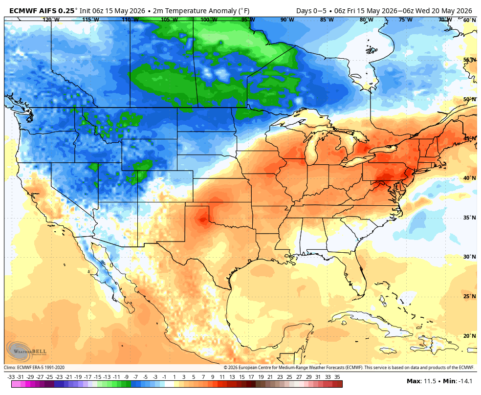
Okay, let's see how good the Euro AI is cause it has big summer weekend number 2, a washout in the NE.
Sat and Sun precipitation. I am sick of all this AI garbage with the weather. The fact is, there are multiple runs of them, all over the place. Sometimes it's outstanding, sometimes just like all the rest. It did very well on Arthur ( Euro products), but was the weakest on the NE blizzard
Euro ensembles and JTWC on typhoon Gonna to be a long hard typhoon season in the west pac. Number impact vs average area. Mexico second, Hawaii 3rd but they may get threatened multitple times this year. Its the revenge of the Pacific, which has been way under ave last 10 yrs
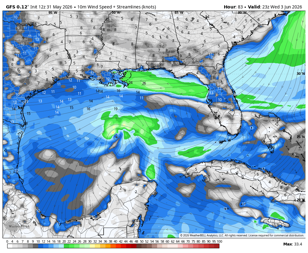
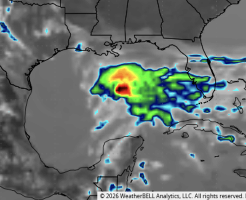
Outline on the gulf on https://t.co/VDPx6GPjEP. Impressive cloud shot midweek in the central gulf with a small low-pressure system GFS has, but would have to pull a Bullwinkle Rabbit out of hat on us with the way the modeling looks
No one is "due" for anything . If you flip a coin 50 times and it comes up heads, the chance of it coming up heads the next flip is still 50-50. The reason New England is a concern to me is not the hurricane drought, but solid meteorological ideas. Phase 6/7 MJO, which we may see a lot of favors that part of the Atlantic and the method I use for max ventilation which is between the blue to the south and red to the north. So like 91 and 76 where storms could develop out of the MDR that certainly is a concern "The punchers chance" in what is a harsh looking pattern exactly opposite 24 in much of the tropics. The strong west shear over New England indicates troughs will be moving through and when they leave for a time there is plenty of ventillation. I have shown this several times. In 24 it was opposite. Remember almost all New England hits have troughs going through Several days before. It then reverses as the trough leaves and the hurricane follows it up
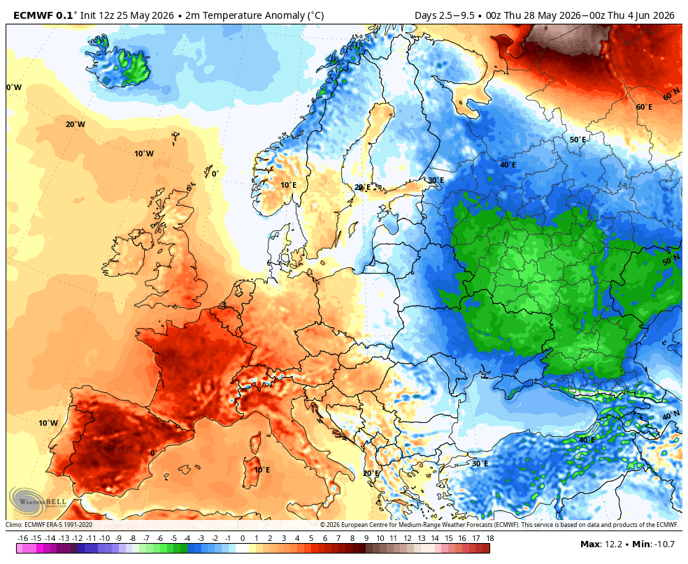
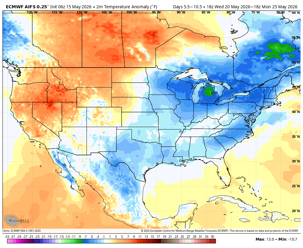
: About 80–120 million more people are in below-normal (colder) areas than in above-normal (warmer) areas for this 7-day period. Why isnt that the bigger news
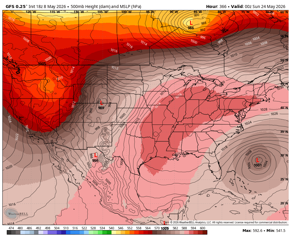
Day 6-9 ECMWF Highest threat of a TC implies development waits for a move near the s Atlantic coast. Major amounts of rain in the gulf day 5-12 extend NE
@ClimateWarrior7 And you have no explanation for of Europe Cold than warm and more of the N Hem cold than warm Or the arctic going below normal and never getting above normal in the summer
D-Day’s vital weather call https://t.co/aQZNYvYVKN
The Movie "Pressure" comes out this weekend. I wrote this first in 2012. A line from the blog
D-Day was one of the highest pressure weather forecasts, if not the biggest, in history
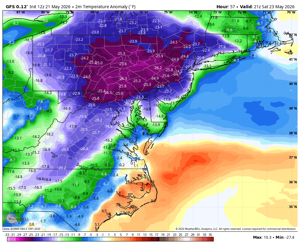
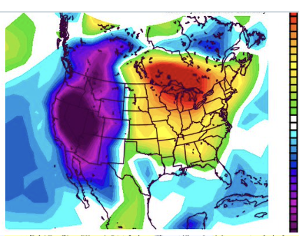
This is almost incomprehensibly cold for May 23, or a Memorial Day weekend ( even with it being early, its still going to blow away May 23 for coldest daytimes so late in the season in alot of places. How is that not national news. A 2-3 day heat wave with less Deviation was)
Heart of the hurricane season MDR shear pattern is opposite the season from hell in 2024. In fact about the only place I would have normal to perhaps above normal impact threat is the northeast Shades of the Bob and Belle el nino seasons. ( this is not for the early season where I do think a gulf system is a good bet)
Its a 3-4 day surge of heat, then out. So much for the deadly heat dome. What irks me about the doom and gloom pushers is on April 26 I showed what was going to happen by using examples in 1966,1977. But because the meteo media just wants clicks, they put no perspective on what they are saying Those 2 maps were put on showing how the cold can flip and in fact is something you should be looking for
The annual early-season GFS tropical cyclone a thon has begun with the 18z run. To be clear I expect an early season development this year most likely in June and further west. Until the MJO rolls around and Euro packages see it, just eye candy. It does have week 4 hints
April 30, 2026 (your tweet at 21:51 GMT / ~5:51 PM ET).
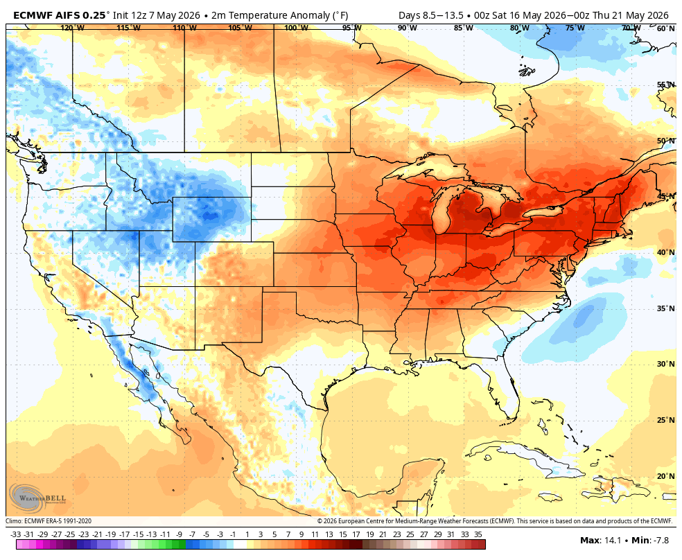
@BigJoeBastardi Exact post:"JMA sending MJO into warmer phases in mid and late May, with a ridge-over-troubled-waters correlation. 1) The out of season eastern cold lets up and even reversesy mid and late month." Bingo Front row Euro flipping and showing it. AI has a real live heat wave
Euro screaming its support for the https://t.co/fJdTSbOesJ idea shown first back in early April with our outlook, for an early season tropical cyclone this year
Mean SLP pattern June 4-10. Remember Pattern recognition and analog techniques were showing this first. Lets see if it happens
Large areas of the east have drought dimininshing rain on the way not only the next 45 days, but likely over the next year as this el nino cranks. So I have issued a hysteria watch for the opposite that the climate cranks are pushing now. Instead of man made induced drought, they will go to too much. However they will hold on to the drought in the west until winter, then do the same then