@papahenz_wx Clear and cool north of the ditch. From the Pink Cliffs on the Paunsaugunt Plateau zoom in and you can actually see the convection firing way down over the I-17 corridor in AZ. Hell of a perspective from up here tonight
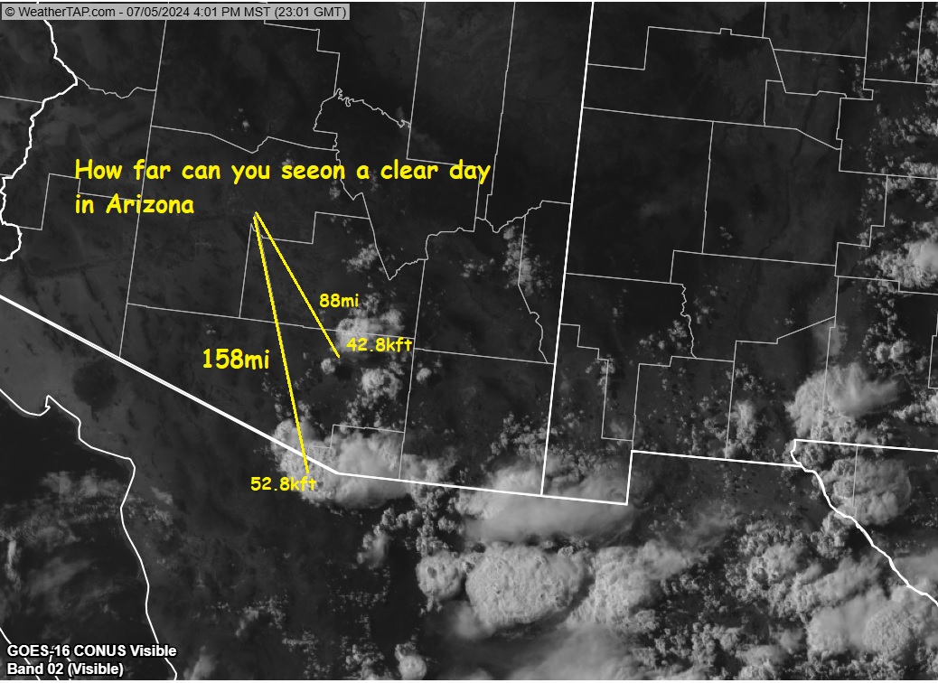
Skies are clear in Phoenix. You probably noticed t-storms to S. How far away are they? Closest one is 88 miles nr Oro Valley and tops at 42,800ft. Far storm is on AZ/MX border near Nogales. It's 52, 800ft tall and 158 miles away. Good eyes. #azwx
Beautiful 80F wx in AZ under sunny skies. Golf anyone! If you're on links you picked a perfect day. Skies will remain mostly sunny through the end of week before another surge of chilly air drops us into 70s mid-week. Pac storm track will target AZ next week for 10-20days. #azwx
AZ mountain areas above 2kft to 12kft will face a nasty fire danger with gusty SW winds, < 5% RH and temps in 80's-90's into Wed. If hiking, camping or visiting the mountains please be careful if you use fire for cooking. Take time to extinguish completely all fires. #azwx
Abandoned campfires are a leading cause of destructive wildfires. They are illegal 24/7/365. If you are camping and have a campfire, you MUST completely extinguish your campfire cold-to-touch before going to sleep for the night or leaving the area for a walk, hike, or to go home. So make sure to bring plenty of water to do so.
Leading edge of OFB#1 is triggering a strong TCu over Tempe where OFB#2 is colliding with it. Expect a windy downpour and then CG lightning in SE Valley as storm grows. Additional storms may pop up this evening. #azwx
Terrain-induced t-storms are rumbling in Yavapai/Coconino Cty. White Mtns should fire up soon. Rain amts reach 0.10-0.30in /per storm at elevations abv 2kft. Late morning temps are 95-100F. Look for desert storms (0.01-0.15in) as OFB's work their magic 4PM-9PM and 4-8AM. #azwx
#NewsRelease The Coconino National Forest has expanded the boundaries of the existing year-round camping and campfire ban located adjacent to the City of Flagstaff in an attempt to lower the hazard from human-caused wildfires.
Photo: map of new closure order.
Cold front/t-storm line with 0.5-0.75in hail and wind gusts 45-55mph is crossing MariCo over next 2hrs. It is moving ESE at 20mph. Strongest storms are over Glendale, Goodyear and Avondale. Be ready. If out on roads, slow down for periods of blinding rain/slick roads. #azwx
The same Government that says it doesn’t want to poke a hole in the Experimental Chinese Spy Balloon because it might injure people,
Is the same Government that had no problems poking holes in people’s arm with an experimental gene therapy for a Chinese Virus.