A boat-shaped formation by itself would be interesting.
But shape is only the beginning.
The scans are revealing tunnels, voids, internal features, and patterns that appear organized rather than random.
A central cavity.
Connected passageways.
Parallel linear features consistent with an intentional layout.
This is why we're scanning the site.
Not to defend a theory.
To follow the data wherever it leads.
And so far, the data is giving us plenty of reasons to keep looking.
BREAKING! This morning, Noah’s Ark Scans announced groundbreaking news regarding the future of the ancient ship:
Researchers are about to launch the most advanced scientific investigation ever conducted at the Durupinar Formation: Also known as the resting place of Noah’s Ark.
Core drilling will begin in 2026, Scientists and experts will also use LiDAR, ground-penetrating radar, seismic imaging, and an underground drone named “Gopher”.
This new research could have major implications for religious beliefs worldwide.
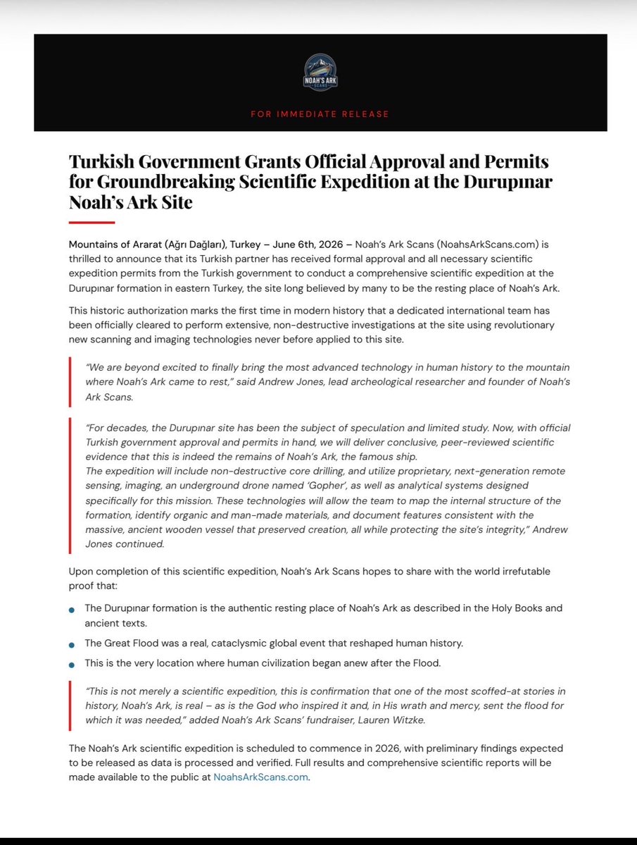
FOR IMMEDIATE RELEASE:
Noah’s Ark Scans is thrilled to announce that we have just received a landmark UNANIMOUS vote of approval from Turkish officials to launch the most advanced scientific expedition at the Durupınar boat-shaped formation ever conducted in history.
We officially have the permits.
We are now preparing to deploy never-before-used, cutting-edge technology on the site. The American team at Noah’s Ark Scans, partnered with aligned scientists and experts, will use LiDAR, ground-penetrating radar, seismic imaging, drone mapping, core drilling, and an underground drone named ‘Gopher’.
For decades, Modern Science has scoffed at the biblical account of Noah’s Ark in Genesis.
But in 2026, the evidence is coming.
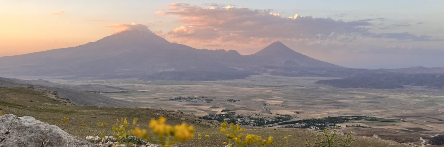
In the mountains of Ararat lies a mysterious boat-shaped formation that is believed to be the remains of Noah's Ark.
Now, American researcher Andrew Jones and his team are investigating the site using ground-penetrating radar, soil analysis, and other advanced technologies.
The scans have identified tunnels, voids, and internal features running through the structure.
Soil studies have also revealed a distinct chemical pattern consistent with the imprint of a large wooden vessel.
With every new scan, we're learning more about what lies beneath the surface.
One of the most fascinating discoveries at the Durupınar site is the boulders found within the boat-shaped formation.
These aren't random rocks.
Researchers have traced them back to the saddleback ridge directly behind the site.
The boulders are limestone, a sedimentary rock containing marine fossils.
In other words, these rocks were formed in water.
Then somehow they ended up incorporated into the structure below.
The more we study the site, the more we find evidence that tells a story of water, movement, and catastrophic forces.
Exactly the kind of world Genesis describes during the Flood.
We asked an American geophysicist to review the scan data from the Durupınar site.
What she found was intriguing.
Approximately 4 meters below the surface is a tunnel-like feature, along with a series of voids running through the structure.
Near the center is a large cavity extending nearly 40 feet down, connected by what appears to be a passageway.
The scans also reveal a series of parallel linear features consistent with an organized internal layout.
Natural formations don't produce this kind of symmetry and pattern.
That's why we're continuing to investigate what lies beneath the surface.
The data keeps giving us reasons to look closer.
New paper is out! Over the last 8 years of fieldwork in N/W Saudi Arabia, we uncovered a series of Neolithic arrowheads, including this absolutely stunning example. This paper was led by @FinnStileman.
As it turns out, these little guys can tell us a lot!
https://t.co/8kXgMsijyR
The conversation around Noah's Ark has been dominated by opinions for far too long.
We're focused on something else:
Data.
Every scan. Every survey. Every new piece of evidence brings us one step closer to understanding what lies beneath the Durupınar formation.
And we're looking forward to sharing what's next.
Our #objectofthemonth is the Peace Treaty between Ḫattušili III & Ramesses II. Read more about this fascinating treaty on our Substack ANEToday! https://t.co/3jTgElEJ9W
📷 ca. 1259 BCE. Airport Museum, Istanbul. Photo by J. Nitschke.
His visit to the reported resting place of Noah’s Ark changed his life forever.
Rick Renner explains how everything lines up for this to be Noah’s Ark.
1. Exact length the Bible describes
2. The place the Bible describes
3. Close to the Silk Road
In 1959, a Turkish army captain named İlhan Durupınar was reviewing aerial photographs when he noticed something unusual in the mountains of eastern Turkey.
A massive boat-shaped formation sitting high above the surrounding landscape.
The discovery quickly made headlines around the world, and many began to wonder if this could be the remains of Noah's Ark.
The reason? The formation matched the biblical dimensions exactly and was located in the same region where Genesis says the Ark came to rest.
Today, modern research teams are using ground-penetrating radar, LiDAR, soil analysis, and other advanced technologies to uncover the truth behind the boat-shaped formation that started it all.
And this is only the beginning.
The Durupınar formation in the Mountains of Ararat (Ağrı Dağları), eastern Turkey was discovered in 1959.
This 515 foot boat-shaped structure matches the EXACT biblical dimensions of the Ark in Genesis 6, and sits precisely in the region Scripture describes in Genesis 8:4.
Geophysical surveys using Ground Penetrating Radar and Electrical Resistivity Tomography have revealed organized linear structures, right-angle corridors, and multiple room-like chambers beneath the surface, features impossible for natural geology but consistent with a massive engineered vessel.
Soil samples from within the formation contain significantly higher organic content than surrounding areas, indicating the decayed remains of ancient timber.
To top it all off.. 26 massive drogue stones (ancient sea anchors) found nearby further support the site, as these artifacts align with technology that would have been needed to stabilize the Ark during the violent Flood.
In May 1948, a series of earthquakes and heavy rainfall triggered major mudslides near Mount Ararat in eastern Turkey.
These events exposed the Durupınar formation, now known as the resting place of Noah’s Ark.
Tassili n'Ajjer, located in a strange lunar landscape of great geological interest, southeastern Algeria 🇩🇿. This site has one of the most important groupings of prehistoric cave art in the world...
More than 15,000 drawings and engravings record the climatic changes, the animal migrations and the evolution of human life on the edge of the Sahara from 6000 BC, to the 1st Centuries of the present era. The geological formations are of outstanding scenic interest, with eroded sandstones forming ‘forests of rock’.
According to UNESCO, the park holds one of the world’s most important clusters of prehistoric rock art.
The artwork is from the Neolithic period, back when this slice of the Sahara was a savanna teeming with wildlife like antelopes, giraffes, and crocodiles. You’ll find images of these creatures etched or painted onto the rocks.
#archaeohistories
High school students in Rome have discovered a spectacularly preserved 1,800-year-old Roman luxury villa directly beneath their school gymnasium.
For years, students at Liceo Scientifico Cavour, located just steps from the Colosseum, passed down rumors of hidden chambers and underground passageways beneath their sports facilities. After a school protest, a group of adventurous teens explored the restricted basement areas, navigating dark corridors that led them to an old boiler room and, eventually, to remarkably intact ancient ruins.
Their Latin and history teacher, Claudia Marino, took the students’ claims seriously and alerted the Special Superintendency of Rome. Official excavations began in early 2026 and have since revealed a high-status second-century AD private residence, now known as the Domus Liceo Cavour.
The villa features vibrant Pompeian-red frescoes, intricate stucco ceilings, and a luxurious black mosaic floor. Inscriptions suggest it once belonged to wealthy Roman elites, possibly including Senator L. Fabius Gallus and later members of the prominent Umbrius family.
Plans are already underway to open the site to the public, with the very students who helped uncover the villa set to serve as official tour guides.
After her cat returned home after being missing for 2 days, a woman fed it and took it beside her, then explained the dangers outside one by one. She talked about bad people, the danger of cars, and dog attacks 🥹❤️
Would you look at how carefully this little one is listening to its owner; it's as if it's promising never to get lost again 🥺😭❤️
Dünya tarihinin akışını değiştiren dönüm noktalarından biri olan Granikos Savaşı’nın gerçekleştiği alanı koruma altına aldık.
Büyük İskender’in Perslere karşı ilk büyük zaferini kazandığı ve Asya’ya uzanan seferinin kapılarını açan Granikos Savaş Alanı artık “Tarihi Sit Alanı” olarak tescillendi.
Çanakkale’nin Biga ilçesinde yer alan bu eşsiz tarihî miras, arkeolojik bulgular ve bilimsel araştırmalar ışığında resmen koruma altına alınmış oldu.
Çanakkale’mizin kültürel mirasına değer katacak bu önemli adımın tarih bilimine, kültür turizmine ve kültür rotalarımızın güçlenmesine önemli katkılar sağlayacağına inanıyorum.