If you're looking for the first week of September to bring cooler weather, you're out of luck...
📈Heat will build over the coming week, bringing highs well into the 90s and heat index values above 100 for most areas outside of the mountains. #gawx
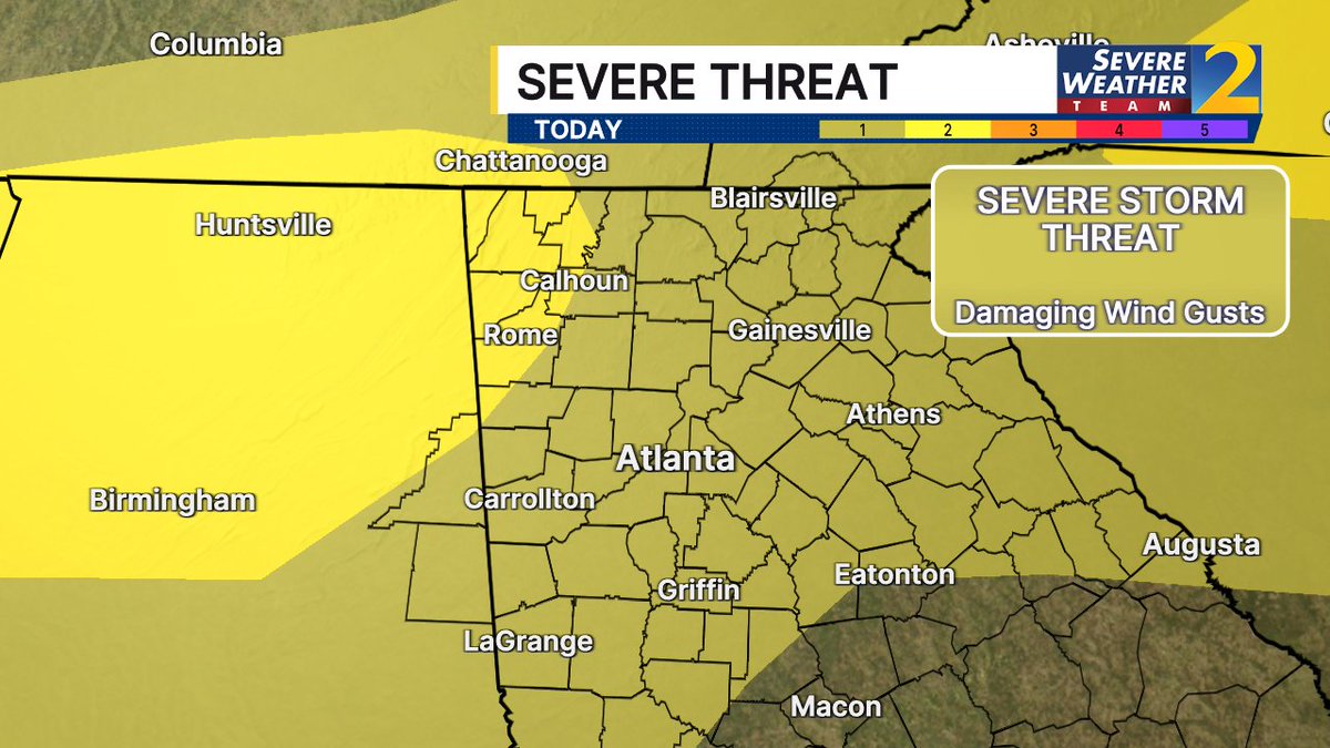
A weak front has pushed into north Georgia, bringing increased chances of scattered to numerous showers and thunderstorms today. A few storms may become severe over portions of the area, with isolated damaging wind gusts as the primary threat.
A weak front is draped over central GA, with scattered showers and thunderstorms occurring across North GA this morning. Expect slow-moving storms to increase in coverage today, bringing heavy rainfall and the potential for localized flash flooding.
Rain and Storm chances increase across north and central Georgia over the next 5 days. 🌧️⛈️ Main threats: gusty winds and frequent lightning each afternoon. Severe weather risk is low, but an isolated severe storm can’t be ruled out. Temps will range from Mid-80s to the Mid-90s.
Eyes on the skies Thursday night/early Friday!
A lunar eclipse will make 96% of the moon appear a deep shade of red as it moves into the Earth's shadow - peaking shortly after midnight.
@FOX5Atlanta
The brief break from Georgia's typical late-August humidity is coming to an end as muggy air, daily thunderstorm chances and temperatures around 90 degrees return to the forecast. https://t.co/vfA37ZN2tC
TUESDAY 🌤 The refreshing change is sustained for another day! Most of North Georgia stays dry with lower humidity, plenty of sunshine, and seasonable temperatures. Scattered thunderstorms return by midweek.
HEADS UP! 🌖🔴 This week a LUNAR ECLIPSE will be visible across the United States Thursday evening into early Friday morning! 96% of the Moon’s visible disk will slip into Earth’s shadow. So close to totality that most of it will have a red tint while only a thin bright sliver remains.
Peak Viewing Times
Eastern: 12:13 AM (Friday)
Central: 11:13 PM (Thursday)
Mountain: 10:13 PM (Thursday)
Pacific: 9:13 PM (Thursday)
Only wild card of course will be your local weather, hope for the best! This should be one of the best lunar eclipses visible from the Unites States until the next total lunar eclipse in December 2028. Enjoy and get those cameras ready!
- Matt Devitt Weather
Drier air behind a front will keep most dry early this week. Rain chances will then increase again by mid-to-late week as another cold front approaches the area.
👀Also, peep the lows in the 60s in north GA (and even a few 50s in the mountains) tomorrow morning! #gawx
A noticeably drier stretch over the next few days will lead to enjoyable weather for outdoor activities. Precipitation chances gradually increase as we progress into the middle of next week.
As the overnight/early morning storms wind down, we’ll head into a partly cloudy, hot, and humid afternoon with scattered storms returning. Some storms could be severe. But there’s a pleasant change for the weekend, including a nice drop in humidity, esp. Sunday! @GoodDayAtlanta
Severe storm threat upgraded in NW Georgia, now level 2 out of 4. The storms will move in this evening and push into the metro area tonight. Damaging wind gusts are the main threat. I'll be tracking the storms live on Channel 2.
The FDA is issuing its highest-level warning for a recall of frozen blueberries and mixed berries across 8 states due to a possible E. coli contamination
⛈️ Keep an eye on the weather later today!
A few rounds of storms may develop across north and central Georgia from this afternoon through the overnight hours.
Some storms may become severe, capable of producing damaging wind gusts, frequent lightning, and heavy rain. #gawx
AFTERNOON HEAT, EVENING STORMS
Most of our Thursday is simply dry and hot.
But our attention turns to gusty storms arriving from the north by this evening. There is a level 1 risk (out of 5) for strong, potentially damaging winds with a few storms - especially between 9pm-3am.