6️⃣8️⃣0️⃣0️⃣ The Pike by the #'s
3-peat @WCACSports Regular Season Champions 🏆x🏆x🏆
🏆x🏆 WCAC undefeated regular season, back-to-back, 28-0
🏆 41-1 WCAC regular season play in 3 years
#PikeCulture
24-0 🏠 winning streak
Why is our confidence continuing to rise in a significant winter storm in the DC area this weekend? If you have a few minutes, here's a video taking you behind the scenes in our forecasting...
Confidence continues to increase on an expansive major winter storm impacting much of the southern and eastern portions of the Country Friday through Sunday. Key Messages are updated.
❄️Weekend winter storm potential is officially on everyone’s radar
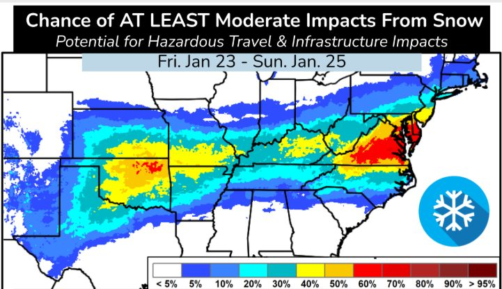
The graphic here is from the National Weather Service, and what really stands out is the huge swath of the country that could be impacted. The Mid-Atlantic is highlighted as one of the more likely regions to see at least moderate snow impacts, with the highest odds just south of D.C.
You may have already seen some BIG snow numbers floating around on weather apps or social media today.
Could those happen? Yes.
Are they a lock or even probable? No.
Why the uncertainty?
The storm is still 5–6 days away, and storm track shifts will make a big difference in what happens.
Our earlier post today (Monday) laying out the four different scenarios still holds.
Bottom line: You’re going to see a lot of different forecasts from a lot of different sources over the next few days.
Stick with us here for steady, science-based updates — without the hype.
More refinements coming Tuesday.