@AccuRayno It was an honor to meet these two gentlemen at the AMS yesterday! Class acts all the way! Always look forward to their forecasts and we even got to work on my own personal forecast for this weekends upcoming storm with Bernie!!
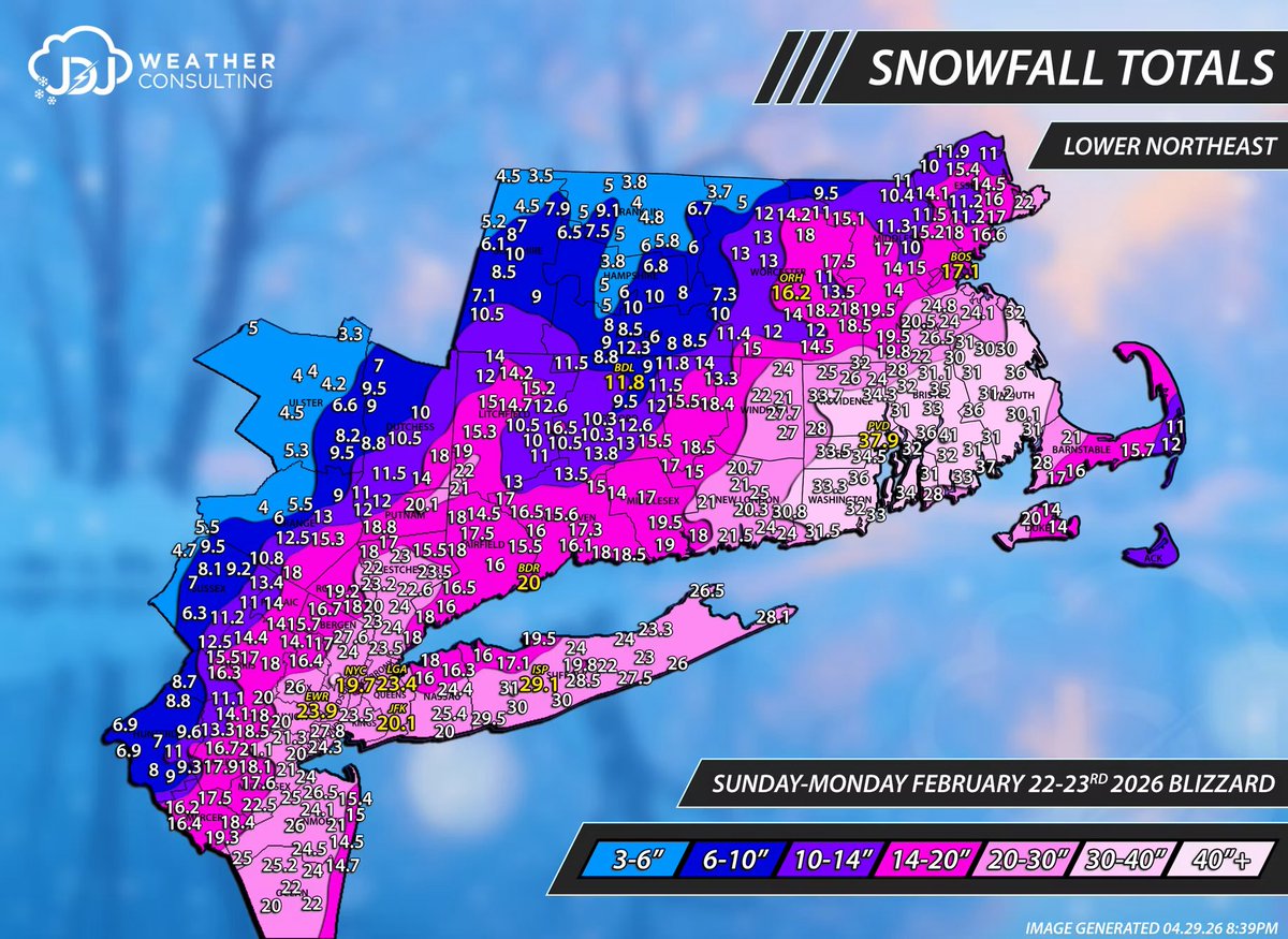
I still think about this most recent blizzard a lot…
Crazy 10-15 miles can make such a big difference for banding.
Places with little to no elevation 36-40”+ of snow.
Would’ve seen 25-35” of snow had that been the case instead of ~18 accumulation.
Great storm for me.
But everyone knows the difference between their all time storms and great storms.
This was an all timer but not for me.
I wrote down some notes right after the blizzard that I’ll explore in a blizzard analysis vid at some point in the coming weeks/months.
But I wouldn’t change too much about this winter tbh.
Would’ve been great to see 30”+ of snow? Sure. But outside of the widespread busts there wasn’t really one system where I was so completely left out.
And it made it so there weren’t too many let downs.
And also I experienced a true blizzard for ~8-10 hours straight. Very rarely get to say that so far inland.
🚨I’m still trying to process what just happened.
The highest ranking US intelligence official, just released smoking gun docs proving that Obama and his underlings committed treason/sedition.
Meaning Trump was right about everything, the news is fake, and the Deep State is real.
Meaning that all of us “conspiracy theorists” were right about the conspiracy against Trump… it wasn’t a theory.
Meaning the shadow war is real, and all our efforts over the last 10 years were not part of a “LARP”.
Meaning that we are not crazy. We were right.
It was all real.
Follow @QuantumGuard17
My algorithm on X tonight is blowing my mind lol..... I just finally realized, holy shit we are entering a new era in technology and AI !! Wow.... That's all I can say
Stop telling ChatGPT "Write me an email"
Stop telling ChatGPT "Write me an email"
Stop telling ChatGPT "Write me an email"
Bad request = Bad result.
Use these commands instead and you'll see the magic:
0z euro …giving us that 1978 scenerio.
Smack dab in middle of timeframe of interest.
day 10.
Monday 3/16.
Will March 2026 follow:
March 1961: no more snow.
March 1978: one more meaningful snow.
Like latest euro showing 👇 in 10 days.
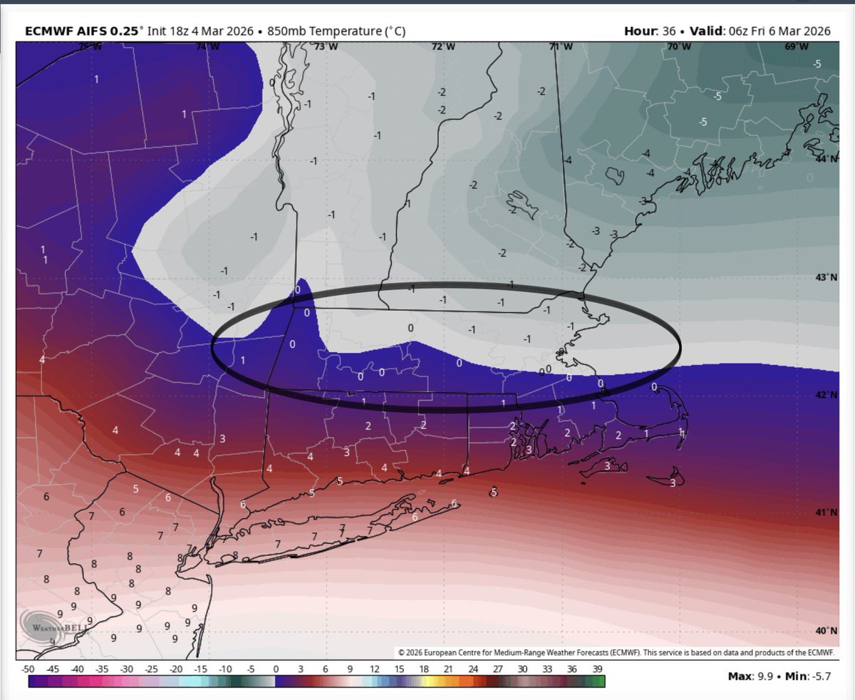
850 is almost exactly specifically where the warm tongue is to a tee for this event and it’s very minor notice during when peak precipitation happens
Notice all of the 0-1 degree margins is where dynamic cooling can make a notable difference and it’s why accumulating to plowable snowfall to go along with sleet versus freezing rain in Mass is my focus.
Models will deceive though(even the hi res).
Legitimate 2-5/4-8+ snow/sleet potential here imo.
There’s an extreme ceiling that’s not impossible for double digits somewhere but not worth putting much weight on with so much mischief at thermals.
Only reason I mention is how much precip is on the table and how heavy the snow rates could be potentially if dynamic cooling does indeed win out
But just thought I bring up all of my passing thoughts going through with a little less filter.
@MetMikeWCVB I mean, GFS has been doing well most of the season right Mike? Wish I made a log to look back and Tally it up. Just a gut feeling that its been the winner for the models this winter🤔🤷♂️
Data has caved to the GFS for a major snowstorm with blizzard conditions Sunday night into Monday from Virginia to Massachusetts. Intense Nor'easter with very heavy snow & 50+ MPH winds at the shorelines and beaches.
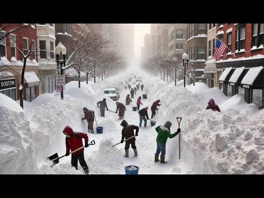
The Boston Burial: Aftermath of the Valentine's Day Blizzard of 2015
The fourth and final major snowstorm of the legendary 2014-2015 winter was an explosive nor’easter that underwent bombogenesis as it tracked northeastward off the coast on February 14-15, 2015. It unleashed heavy snowfall rates of 2-3 inches per hour (bursts up to 3-4 inches in the strongest eastern bands near Boston), ferocious winds gusting 55-65 mph, relentless blowing snow plunging the region into blinding whiteout conditions—and hours of dramatic thundersnow across eastern Massachusetts on February 15. This marked the second official blizzard to slam the area in just three weeks!
It dumped another 16.2 inches on #Boston (official tally at Logan Airport), pushing on-the-ground snow depths to over 3 feet across much of southern New England. Boston-area reports reached around 42 inches on the morning of February 16—burying streets, cars, and sidewalks in a frozen tomb.
To make matters worse, temperatures plunged to a bone-chilling -3°F, with wind chills dropping to -30°F (or even colder in the strongest gusts), turning the overwhelmed city into a wind-whipped icebox where every breath burned and survival felt like a relentless battle against nature.
Towering snowbanks loomed like frozen cliffs along every street—piles and banks surging 10-15 feet high (or more in plowed heaps)—transforming narrow roads into treacherous tunnels and making driving a white-knuckle gamble through impenetrable walls of white.
This Valentine's Weekend knockout punch capped a brutal sequence of storms that turned Boston into a surreal, snow-entombed landscape. In an unfathomable three-week stretch from late January through mid-February, nearly 8 feet (about 95 inches) of snow fell on the city—four relentless nor'easters in quick succession that obliterated records and left nothing melting in the persistent deep freeze.
On a personal note, I chased and documented this particular #blizzard on the Cape Ann Peninsula in Rockport, which recorded 14.5 inches of new snow—where I witnessed thundersnow during the early morning hours of February 15 and spent almost two hours battling strong winds and heavy snowfall to dig out my SUV (and those of two other stranded persons nearby). I continued filming through the morning and afternoon at the Harbor, capturing the relentless bands. As the storm pulled away, arctic air surged in behind it. In the early overnight hours of February 16, I stepped outside my hotel to endure wind chills pushing toward -35°F (the arctic air and gusts made exposed spots feel brutally colder). Before heading south later that morning, I measured a snow depth of 38.5 inches right there at the hotel in Rockport.
Then, driving through Boston en route home, I navigated the snow-choked streets and towering drifts—stopping along the way to help dig out a few more stranded vehicles and clear paths where I could, documenting the city's buried chaos firsthand. In the days that followed, as the region dug out, neighbors and volunteers pitched in across Boston and beyond—clearing sidewalks for the elderly, helping restore power access, and slowly reclaiming streets from the frozen tomb. The cleanup was monumental, with plows working overtime, massive snow piles lingering for months, and the city gradually returning to life amid the lingering cold.
The aforementioned scenes were from my own observations throughout the area. It was the culmination of an epic adventure documenting the winter of 2014-2015 in eastern Massachusetts—one that ultimately set the all-time seasonal snowfall record for Boston at 110.6 inches at Logan Airport.
Even now, eleven years later (on this February 14, 2026 anniversary), the memories—and the photos/video—still feel larger than life.
#WinterStorm