#Rafael has emerged into the Gulf of Mexico as a Category 2 #hurricane with max winds of 105 mph. Rafael is the first Cat. 2+ Gulf hurricane in November since Ida in 2009.
You may notice closer to day 5, the cone widens again. High pressure over FL Wiil push the system west, letting it to slow down & stall.
In 72 hrs, The GFS suggests a N track
NHC keeps the system in the Gulf. It should start to weaken by Friday.
NEW Potential Storm #18 in Caribbean moving slowly NE and likely to strengthen. Tropical Storm Warning for Jamaica & Hurricane Watch for Cayman Islands. Here’s the initial forecast track from NHC. #tropics https://t.co/KVLgdayxvD
2 PM Tropics update with a very high chance of a depression or storm forming in the Caribbean. It’s likely we’ll see slow development (early week). Stay tuned for updates and future track forecasts. #tropics@7Weather https://t.co/v30A0hAaPq
Hurricane Oscar: Current winds are at 80 mph (Cat 1) as Hurricane approaches the northern coast of E Cuba. Oscar is moving slowly at just 7 mph. The forecast calls for Oscar to turn northward, next couple days. #Hurricane#Oscar @7Weather https://t.co/aF4nNaSENK
Oscar upgraded to a Hurricane. #Hurricane warnings posted for the Turks & Caicos and SE Bahamas. Oscar expected to take a NNE turn on Monday. Not a Florida threat. @7Weather https://t.co/cjOpOvDQAb
Tropics update, Sunday PM: NHC is watching 1 area in the distant Atlantic. Conditions are currently unfavorable for development but that could change as disturbance heads west (late-week). Medium Chance to become a Depression, over next 7 days. #Tropics https://t.co/v30A0hAIEY
#Milton won’t be only a Gulf coast event for Florida. Strong, damaging, even life-threatening winds could occur in some farthest inland locations and all the way to Atlantic coast. Coastal & inland areas will risk rain-induced floods, and even Atlantic coast could get some surge.
2PM tropics: Areas in orange (Caribbean to Gulf, distant Atlantic) have medium development chances of tropical development into next week. Keep checking for updates during this often-active time of the season. https://t.co/v30A0hAIEY
Tropics Update: Low Pressure in the SW Gulf is likely to become a tropical storm as it lifts north. Meanwhile 2 distant disturbances in the Atlantic are ripe for development in the days ahead. There’s now a better chance for those areas to get stronger. https://t.co/v30A0hAaPq
2 PM Tropics: High chance for a tropical depression to form in the next day or two. System will approach the Lesser Antilles where watches and warnings may be issued later today or Monday.
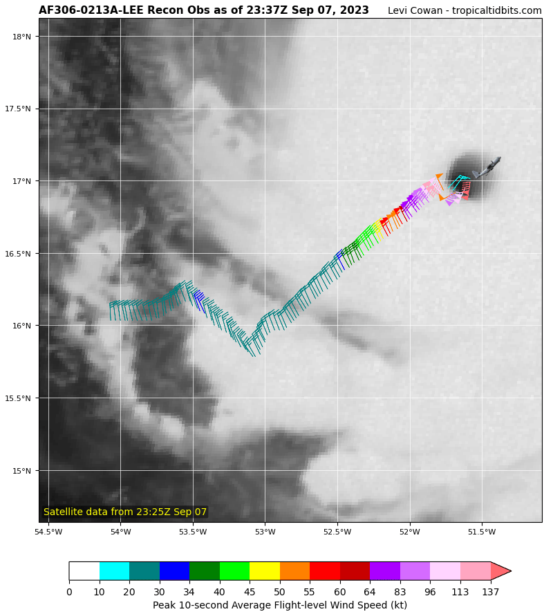
Tuesday Evening Tropical Update: Invest 94L is producing more t-storm activity. NHC says it has 35 mph winds & could organize in red area over a period of up to 7 days. They're giving it an 80% chance of that happening. NOAA Recon set for Wednesday.
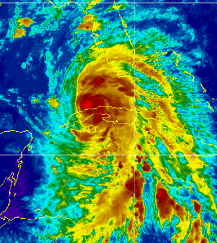
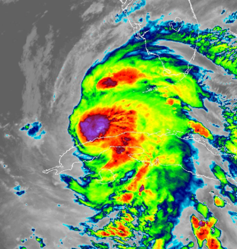
Over the course of a 12-hour time-span, Hurricane Lee rapidly-intensified from a category 1 to a category 4 storm.
This sunrise-to-sunset imagery shows Lee's evolution today and the development of its impressive eye. It is expected to become a category 5 in the next day.