A coalition of law enforcement, fire service, health care, public health, public works, EMS, military, and partner agencies from Cape Cod and Nantucket.
Hurricane season is here. It only takes one storm to impact Cape Cod and the Islands. Now is the time to review your emergency plan, build an emergency kit, know your risks, and stay informed. Learn more: https://t.co/xWmgJfCX1U
#CapeCod#EmergencyPreparedness#StormReady
Cape Cod Shelter Update
➡️ Shelter travel is permitted under the ban, but roads remain hazardous — travel only if necessary.
Open:
➡️ DY Regional HS – opens 8 PM
➡️ Barnstable Intermediate School – open
➡️ Nauset – now closed https://t.co/1uojLtOMbO
⚡ Power outages reported across Cape Cod due to heavy snow & strong winds.
Report outages:
Eversource 1-800-592-2000
National Grid 1-800-465-1212
Stay off roads. Avoid downed wires.
Updates: https://t.co/1uojLtOMbO
Barnstable County: Shelters Open
• Nauset Regional High School (Eastham)
• Barnstable Intermediate School (Hyannis)
Travel is dangerous. Stay home unless leaving for safety.
Shelter Map & Important Information: https://t.co/5KkIJsTX4k
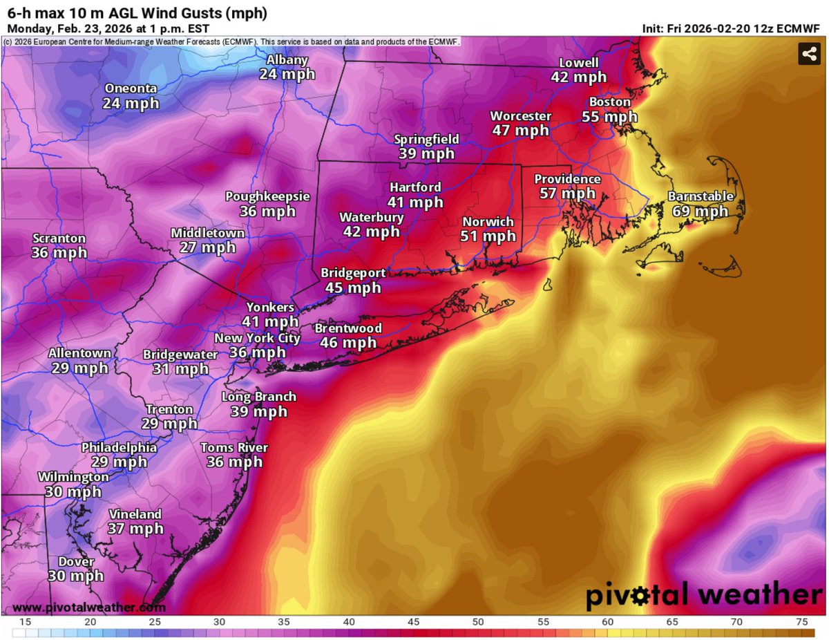
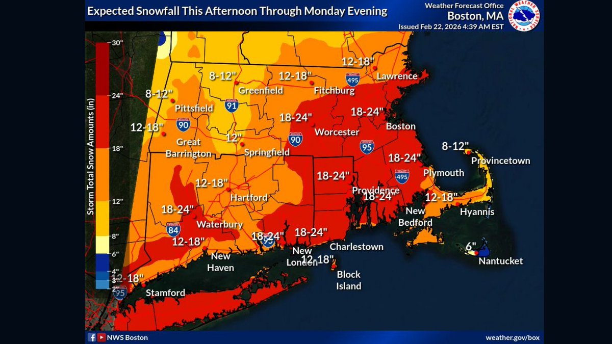
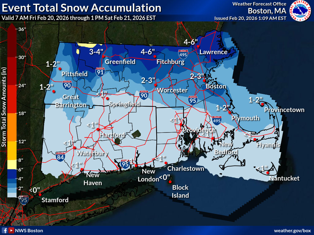
Blizzard Update – 5:30 PM Feb 22
Barnstable County has released a new storm update.
Blizzard conditions expected overnight–Mon.
Worst conditions Mon morning–early afternoon.
2 regional shelters open tonight. See locations and all details:
https://t.co/1uojLtOMbO
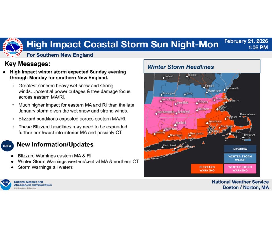
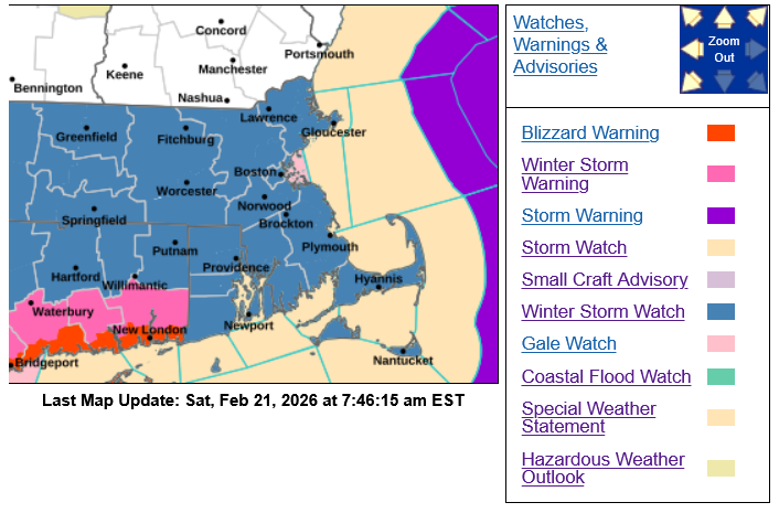
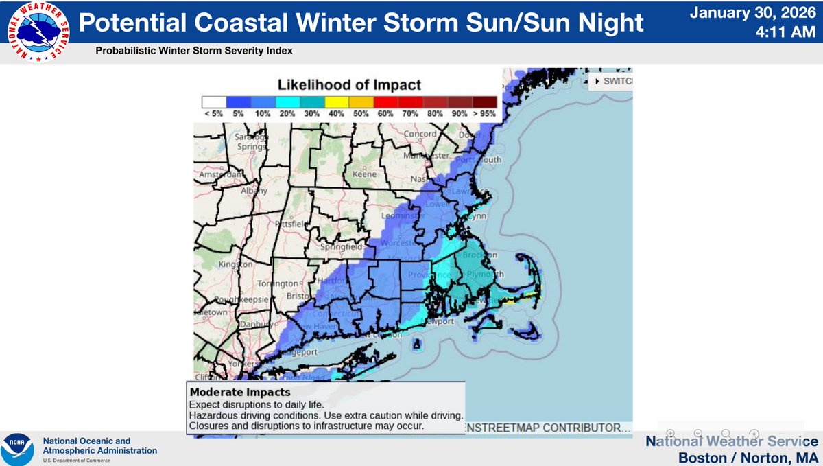
Storm Update: Read Barnstable County Situational Report #002. Blizzard Warnings in effect for Cape Cod & Martha’s Vineyard. Major storm expected Sun PM–Mon with heavy snow, strong winds, power outage risk & dangerous travel.
Prepare now https://t.co/jxu4fstlSH
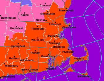
Storm Update – 3:30 PM 2/21
Blizzard Warning for Cape & Vineyard Nantucket under Winter Storm Watch.
➡️ 12–18” heavy wet snow possible ➡️ Peak snow after 2 AM Mon–PM ➡️ Gusts 40–60 mph, isolated ~70 mph ➡️ Coastal flooding possible Mon AM high tide
https://t.co/1uojLtOMbO
Major winter storm possible Sunday night into Monday on Cape Cod.
➡️ 12–18” heavy wet snow possible
➡️ Gusts up to 70 mph possible
➡️ Coastal flooding possible
➡️ Potential multi-day power outages
Prepare now. Avoid travel during peak impacts Monday.
https://t.co/1uojLtOMbO
As of 10:30 AM, Feb. 20, BCREPC is monitoring a wintry mix expected later today into Saturday.
Limited impacts expected on Cape, but slick spots are possible evening + overnight.
We're also watching a Sun–Mon system. Confidence in track + totals remains low. Follow for updates.
💙 In light of the tragic Eastham event this past weekend, we want to remind residents to exercise extreme caution on ice. Our hearts are with neighbors & we thank first responders. Keep children & pets close. Stay off ice. Learn more: https://t.co/bEopcAosSC
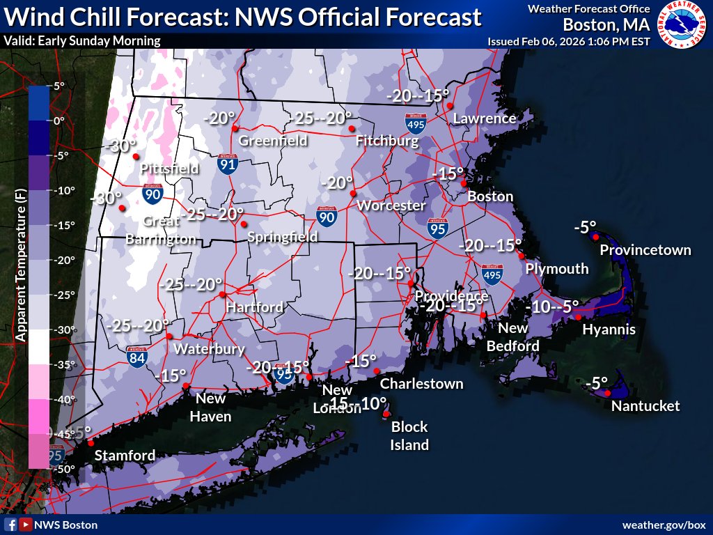
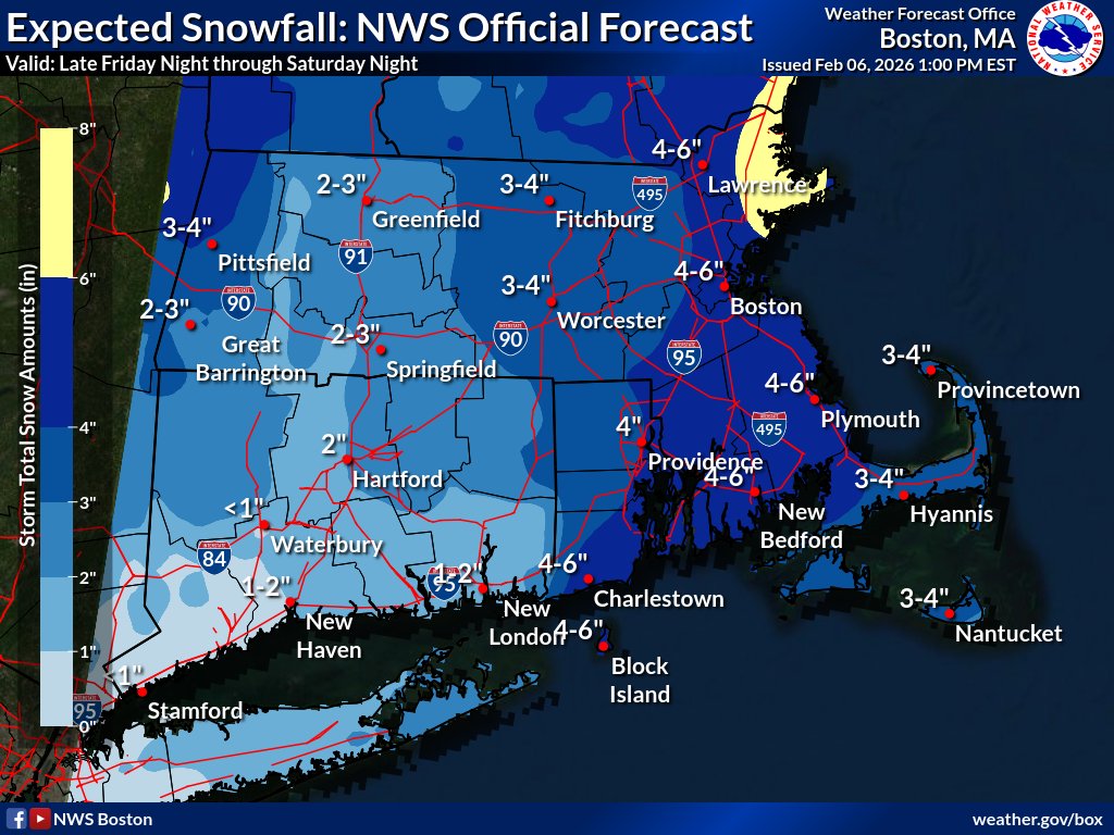
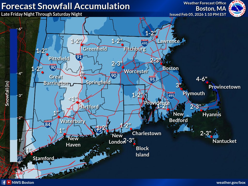
Weekend Weather Update for Cape & Islands | 3:30 PM 2/ 6
A Winter Storm Watch/Weather Advisory in effect. Snow tonight–Sat (3–4” avg), followed by dangerous cold Sat night–Sun with wind chills -5° to -15° + gusts up to 40 mph.
🔗Full update: https://t.co/tDfYUXQR4q #CapeCod
Snow Friday night into Saturday, then dangerously cold temps & wind chills this weekend across Cape Cod.
BCREPC is monitoring conditions. Stay safe & bundle up.
Updates: https://t.co/1uojLtOMbO
#CapeCod#WinterWeather
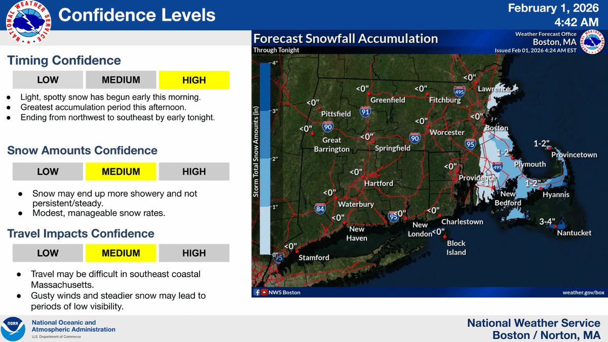
Winter Weather Update: 8:30 AM | Feb 1 Minimal snow expected (~1 inch or less). No winter storm warning or watch for snowfall. Advisories remain in effect. Gusty winds and some localized icy spots are possible, especially near the coast.
https://t.co/1uojLtOMbO
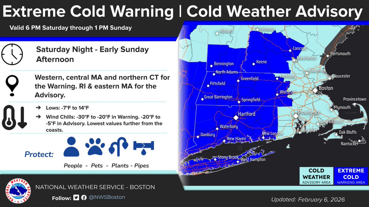
Barnstable County Regional Emergency Planning met today to review the latest forecast/regional planning for a winter storm expected Sunday into Sunday night. Dangerous cold continues + a coastal storm may affect Cape & the Islands Sunday. Stay informed! https://t.co/1uojLtOMbO
Extreme cold continues thru Saturday across Cape Cod, with dangerous wind chills. Limit time outdoors. Take precautions for people, pets, and pipes. A coastal storm may impact the region Sun into Mon. Snow could begin Sun AM. Snow totals remain uncertain. https://t.co/1uojLtOMbO
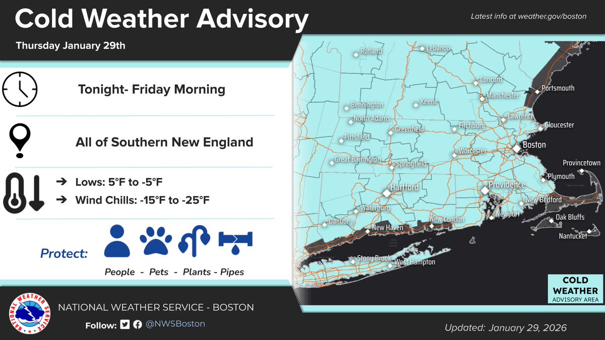
🥶 Dangerous cold expected tonight into Friday morning for Cape Cod,
🌡️ Lows near 0–5°F
💨 Wind chills down to –5°F to –10°F
Limit exposure and protect pets & pipes. More storm guidance later today. https://t.co/1uojLtOMbO
⚠️ Winter Storm Update | 9:00 AM | 1/26
Heavy snow ended across Cape. Light snow may linger today. Travel may remain challenging— limit travel to allow DPW & utility crews to work. Minor outages being addressed. The MACC is standing down in person but remains available virtually.