@OleleSalvador@googlemaps@googleearth@DTSIntelAfrica I agree with you, hence verifying the raw data from the source. However, I can't confirm if its as result of image (tile) rendering which uses historical data, but can definately be misleading.
No matter what, the truth about galamsey’s impact cannot be hidden or censored.
Hey Founder I found UX & Wireframe Figma Templates for you ✨
Help you saved ton time and money
Like & Repost, Comment "UX" to receive the link.
Must be following so I can DM you 💬
Create by big agency
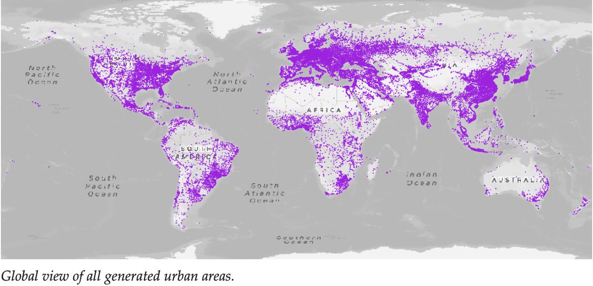
Release of the global urban areas dataset available in daylight: vectorized urban area features derived from the European Space Agency’s 2020 World Cover (10m) rasters 👌.
⌛️Download: https://t.co/x1bCYfqfa0
📢ANNOUNCEMENT📢
Join me in a coding session with @tiangolo and learn how to build an AI app with @FastAPI and @Docker.
During the session, there will also be a giveaway to win Docker swag!🐳🥳
🗓️Thursday, August 31, 4 pm CET:
https://t.co/fHZMa0CnNf
You can now map your thoughts, and share your #geospatial insights with our new article feature, a perfect way to keep your network up to date with the latest developments
Click the link to get started
https://t.co/q8ohY7Sa2h
📢#JobAlert‼️ Do you like #dataviz & working with satellite imagery? What about working in a dynamic international and inclusive team as a #EO Data visualisation specialist. 🛰️🎨 ⏩More info at https://t.co/XC6YPGWoiP ⏪ RTs welcome.
Ah! And what about seeing your results published by official European Commission #SM accounts? Do not miss it; Check it out! #Vacancy #EOChat