Blogger, podcaster, writer, PR person, runner/triathlete and musician in central NJ. Rider University/The Rider News alumnus. Making music as @fdmusic_nj
Still don't understand why @HamiltonTwpNJ continues to honor this corrupt, fascist hack. He is a national disgrace and it's embarrassing there is a street named after him here.
https://t.co/LQjmnEzEY0
@theeelsdeal@nj1015@myWeatherNJ@nynjpaweather@CNN@FoxNews Saw someone in a Six Flags Great Adventure FB page post that they saw it while riding Nitro, which sounds awesome (especially since the coaster opened 25 years ago today).
@10arc10 @JoeMelba @KSlideStudios Don't know if it's related, but I was on I-295 around 2:40ish today & passed 3 flatbed trucks each carrying large sections of wrapped framework just before the I-195 exit toward SFGA. And I saw they got off on I-195 East behind me. Could be the support structure.
@epawawx I get that. But I think NWS may have been thinking back to last year when it seemed like areas west of here would be under a severe thunderstorm watch and areas outside the watch area wound up getting hammered.
@epawawx When I was tracking it coming through SW NJ, there were several ~60 mph wind spots near Elmer, Glassboro and Swedesboro. Numerous reports have since come in with 60+ mph wind gusts with damage.
So weird the @AsburyParkPress still has this completely wrong story on its website. @NWS_MountHolly did preliminarily confirm a blizzard in Monmouth and Ocean counties on Feb. 23. APP only checked with NWS New York office, which doesn't cover the area. https://t.co/AZ5HUIjlEy
@bentomfohrdeWX@burgwx A lot of Mercer got caught in subsidence 2 or 3 times from 9pm-midnight Sunday. First time, between that intensifying NW band & weakening SE band. Next, after NW band faded & SE band moved through, it pulsed up again. That repeated again with the next bands. Went to bed angry.
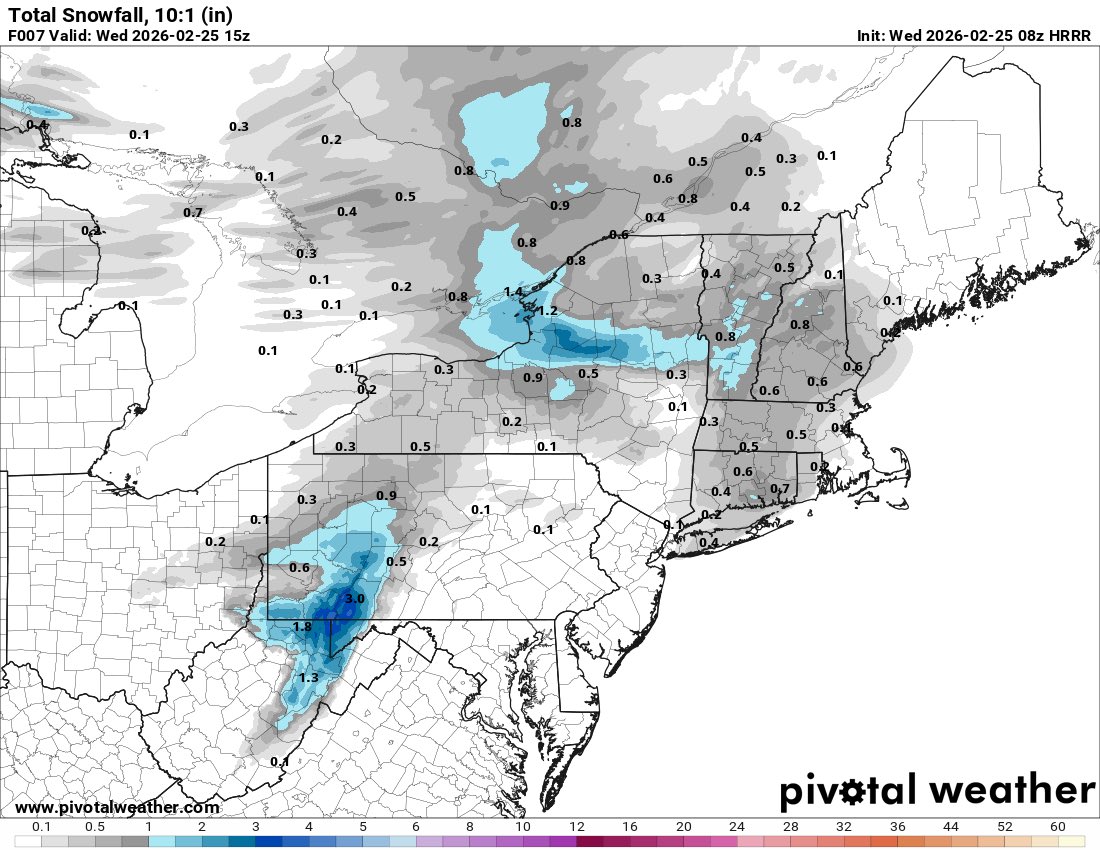
@nynjpaweather Did the HRRR just take off this morning or something? It's an hourly model and it hasn't come close to getting this snow event right all morning. Overdoing warmth and underdoing precip in real time. The 08z snowfall map through 10 am compared to reality is such a fail.
@SteveOweathaguy And then that band NW of us pulsed up so the approaching SE band weakened. Just as it passed through, it pulsed up again and set up just NW of us. And we got into another screw zone.
@SteveOweathaguy I was hoping for 23" here just east of Trenton because I remember measuring 22" as a 6yo in Brick, NJ, in 1978. Could've made a run at it except we got stuck in subsidence from the surrounding bands Sunday night. Location on SE edge of circle got 25"...we ended up with ~15" 😡
Revisiting @njdotcom's 2025-26 winter preview from November. Aside from the Farmers' Almanac last-ever winter outlook, @nynjpaweather was the only source included that called for "near to above-normal snowfall.” 🎯
https://t.co/RrTlF29wvC
@nynjpaweather Big chunk of Mercer County got screwed by subsidence between two snow bands around 9 p.m. last night. Robbinsville, 3 miles east of me, got into that stronger SE band for a bit, but it weakend as it got to us. They picked up 19"+ & we ended up with ~15-16"
So far the storm as a whole is generally evolving as expected. The 18z HRRR was a bit too low with reflectivities with the developing snow band over DE into central NJ & Long Island.
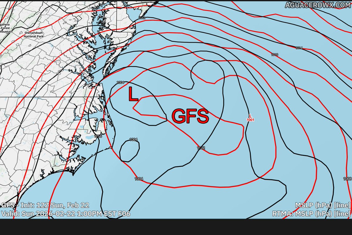
This is why @aguacerowx is so good. We can directly compare the mesoscale analysis to models.
Both the GFS and the NAM have the Low-pressure development too far east by 50-100 miles.
How that will impact downstream remains to be seen. But I would be careful with this east bump
Comparison of HRRR simulated reflectivity vs. MRMS mosaic:
- Precipitation field in the large scale is generally evolving as modeled, perhaps slightly east of the HRRR in PA but hard to tell from a glance if this is legit or due to terrain beam blockage
- Frontogenetic band moving through DE is producing heavy precipitation, with bright banding evident as evaporative cooling & wetbulbing is inducing a changeover to heavy wet snow with large aggregates. In that sense the banding showing higher reflectivity than modeled doesn't say much about its intensity, though it does seem to be progressing north a bit faster than modeled, characteristic of snow bands in warm air advection environments