*जल संसाधन विभाग*
*सूचना:*
नेपाल में आई बाढ़ : अभी का पानी 8:30 बजे अप० में गंडक बैराज, वाल्मीकिनगर पहुँचा है, जलस्तर लगभग 20,000 क्यूसेक बढ़ा है। 11 बजे रात तक पीक होगा और उसके बाद डाउन होना शुरू होगा। जलश्राव अधिकतम 2 लाख क्यूसेक रहने की संभावना है।
China despite have on ground equipments & extremely advanced satellites, didn't tell Nepal in advance to save lives. Isn't China 1000 years ahead in technology.
Rumours???
They are litreally sending me de@th threaths ??? For speaking up in my dms ??
iam speaking up for nepal but your lots are cursing my family
when all i have done is tell people how your low quality material caused this to nepal
iam really sick to the core !!
A second flight has just taken off, carrying 37.5 tonnes of HADR material, medicines & food packets for Nepal.
India remains in close and continuous touch with the Nepalese authorities. We will continue to strongly support the ongoing relief efforts.
🇮🇳🇳🇵
This will cause 5x rise in hate from Nepal against India. Similar to sending vaccine to Latin America caused 10x rise in hate from LatinX against Indians.
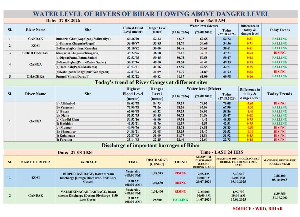
Discharge( cusecs) at Gandak Barrage
Date : 27.08.2026
At 12:00 AM - 1,50,200 (S)
At 00:30 AM - 1,42,100 (F)
At 01:00 AM - 1,29,000 (F)
At 01:30 AM - 1,16,500 (F)
At 02:00 AM - 1,04,400 (F)
At 02:30 AM - 95,200 (F)
At 03:00 AM - 88,300 (F)
At 03:30 AM - 83,900 (F)
BREAKING: We have our first satellite images of the devastating Nepal/China floods, courtesy of our hardworking friends at Planet Labs, Inc.
This shows the Triushuli River more than quintupling in width and rising by 50-100 feet in some spots. For the hundreds reported missing, and presumed dead, there was simply no warning nor escape.
This is about 40 miles north of Katmandu, the capital of Nepal.
An extreme landslide, equivalent in strength to a magnitude 5.2 earthquake, ruptured with the force of 950 tons of exploding TNT. That was enough to essentially break a natural dam, allowing torrents of water (much of it meltwater from mountain snowpacks that melted over many years, i.e. a glacial lake) to be released.
The Trishuli River is a tributary formed by the merger of the Kyirong Tsangpo and Lende Khola rivers originating in Gyirong County of Tibet.
It's unclear where the floodwaters came from. There are several large glacial lakes in Shigatse, China. Each occupies its own endorheic basin, meaning there's no outlet for the lakes' waters to drain.
It appears a massive chunk of ice from one of the glaciers shifted or broke, opening a glacial lake to drainage into one or more river valleys.
Regardless, floodwaters rushed southwards down the Trishuli River through the Rasuwa District of Bagmati Province, gushing through the river valley and inundating virtually every community along the Pasang Lhamu Highway.
That populous corridor included the Friendship Bridge in Rasuwagadi, where Nepal and China meet.
Whole world saw Chinese border control building collapsing. Weren't any Chinese national in that building. U could have gave live satellite data to Chinese people there to save their life.
जरूरी सूचना
दिनांक 26.08.2026 को रात 11 बजे गंडक नदी का जलस्तर 1,50,200 क्यूसेक के पीक स्तर पर रहा। इसके बाद जलस्तर में लगातार कमी दर्ज की गई। हालांकि, देवघाट क्षेत्र में देर से हुई वर्षा के कारण गंडक नदी के जलस्तर में पुनः वृद्धि दर्ज की जा रही है।
Discharge(cusecs) at Gandak Barrage
Date :27.08.2026
At 12:00 AM- 1,50,200 (S)
At 00:30 AM- 1,42,100 (F)
At 01:00 AM- 1,29,000 (F)
At 01:30 AM- 1,16,500 (F)
At 02:00 AM- 1,04,400(F)
At 02:30 AM- 95,200 (F)
At 03:00 AM- 88,300 (F)
At 03:30 AM- 83,900 (F)
At 04:00 AM- 81,400 (F)
At 04:30 AM - 79,700 (F)
At 05:00 AM - 79,700 (F)
At 05:30 AM - 81,800 (R)
At 06:00 AM - 88,300 (R)
At 07:00 AM - 92,900 (R)
At 08:00 AM - 99,800 (R)
At 09:00 AM - 1,04,400 (R)
(S : Steady, R : Rising, F : Falling)
जल संसाधन विभाग बाढ़ से सुरक्षा के लिए पूरी तरह मुस्तैद है।
Discharge(cusecs) at Gandak Barrage
Date :27.08.2026
At 12:00 AM- 1,50,200 (S)
At 00:30 AM- 1,42,100 (F)
At 01:00 AM- 1,29,000 (F)
At 01:30 AM- 1,16,500 (F)
At 02:00 AM- 1,04,400(F)
At 02:30 AM- 95,200 (F)
At 03:00 AM- 88,300 (F)
At 03:30 AM- 83,900 (F)
At 04:00 AM- 81,400 (F)
Initially, it was thought that an earthquake near the Nepal-China border triggered the catastrophic flash flood down the Bhotekoshi River today.
However, further analysis suggests that the glacier collapse ITSELF caused the earthquake.
Yes, you read that right. A Magnitude 5.2 seismic shockwave caused by a colossal landslide of ice and rock on the Earth’s SURFACE. This is actually insane.
The low quality dams built by China in Chinese occupied Tibet created flash floods in Nepal. Sigh, so much loss of life because of china and its low quality raw materials.