Meteorologist for @1011_News Severe Weather Center in #LNK. Watch me weekdays on 10/11 This Morning (5-7 a.m.), Pure Nebraska and streaming on 1011 NOW.
A Severe Thunderstorm Warning has been issued for Chase, Perkins Co(s) until Jun 08 11:30AM MDT. Large hail, damaging winds, torrential rain, and frequent lightning are possible. For more info, visit https://t.co/VpBhKND6K9 #NEwx
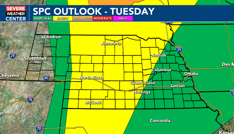
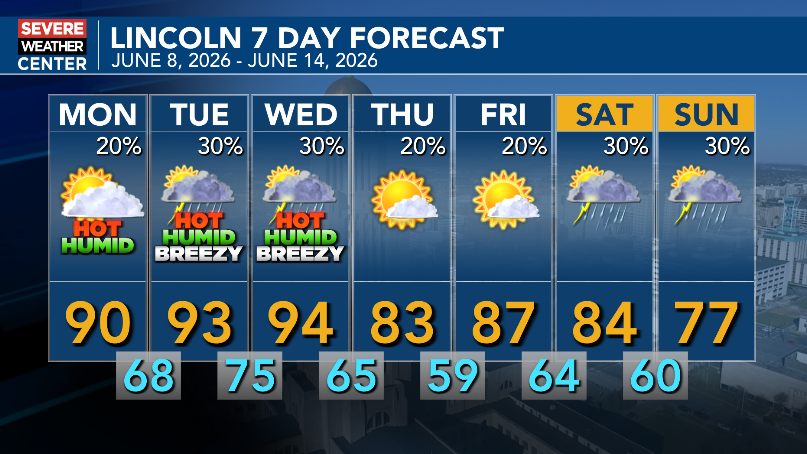
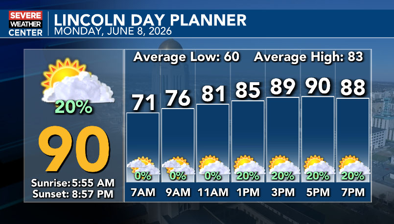
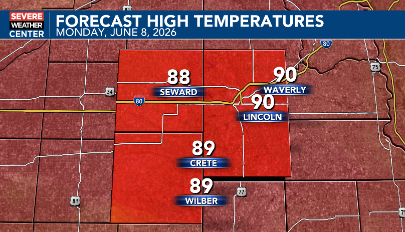
Hot and humid first half of the week, then cooler and potentially less humid second half of the week. Heat index values could reach 100 to 105 Tuesday & Wednesday afternoons. Best chances for showers and thunderstorms are Tuesday, Wednesday and this weekend.
A Severe Thunderstorm Warning has been issued for Custer Co(s) until Jun 08 11:00AM CDT. Large hail, damaging winds, torrential rain, and frequent lightning are possible. For more info, visit https://t.co/VpBhKND6K9 #NEwx
A Severe Thunderstorm Warning has been issued for Buffalo, Dawson Co(s) until Jun 08 11:00AM CDT. Large hail, damaging winds, torrential rain, and frequent lightning are possible. For more info, visit https://t.co/VpBhKND6K9 #NEwx
A Severe Thunderstorm Warning has been issued for Dawson Co(s) until Jun 08 10:15AM CDT. Large hail, damaging winds, torrential rain, and frequent lightning are possible. For more info, visit https://t.co/VpBhKND6K9 #NEwx
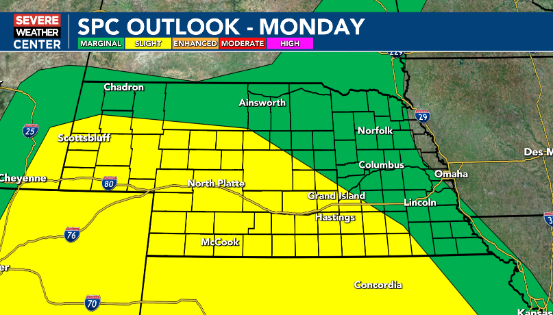
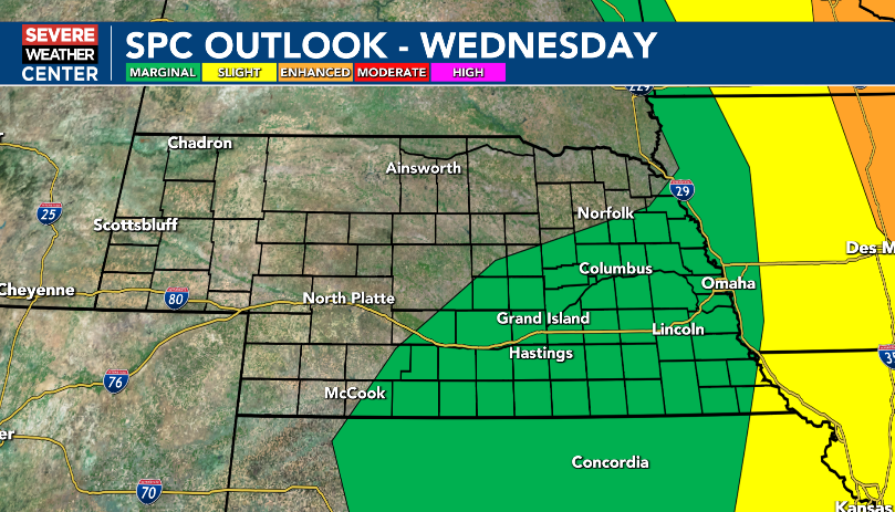
Monday morning update: Isolated to scattered severe thunderstorms are possible in the area Monday, Tuesday and Wednesday. Large hail and damaging winds are the main threats. The tornado threat is low.
7:45am Monday update: Dense Fog Advisory in effect for part of South Central Nebraska until 10am Monday. Visibility one-quarter of a mile or less likely.
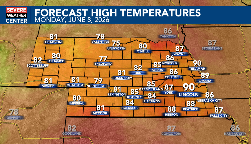
Partly to mostly cloudy, hot and humid today. There is a 20% chance of isolated showers and thunderstorms this afternoon and evening. East and southeast winds at 5 to 15 mph.
A Severe Thunderstorm Warning has been issued for Perkins, Keith Co(s) until Jun 08 3:30AM MDT. Large hail, damaging winds, torrential rain, and frequent lightning are possible. For more info, visit https://t.co/VpBhKND6K9 #NEwx
It has been very active over the last 24 hours! Storms yesterday into the overnight hours produced 2 to nearly 5 inches of rain! Lincoln officially only recorded 0.10", but just southwest of Aurora, there was 4.75".
EXTENDED: The Severe Thunderstorm Watch will now be in effect until 2 a.m. Saturday, as we continue to monitor the threat of some hail, gusty winds and flash floods these with late-night storms. #NEwx
A Flash Flood Warning has been issued for Lancaster, Gage Co(s) until Jun 06 1:30AM CDT. Be prepared to move to higher ground and NEVER drive through flooded roadways! Turn around, don't drown! #NEwx#NEwx
A Severe Thunderstorm Warning has been issued for Seward, Lancaster Co(s) until Jun 05 9:30PM CDT. Large hail, damaging winds, torrential rain, and frequent lightning are possible. For more info, visit https://t.co/VpBhKND6K9 #NEwx
A Severe Thunderstorm Warning has been issued for Lancaster Co(s) until Jun 05 9:45PM CDT. Large hail, damaging winds, torrential rain, and frequent lightning are possible. For more info, visit https://t.co/VpBhKND6K9 #NEwx
A Flash Flood Warning has been issued for Saline, Gage, Jefferson Co(s) until Jun 06 1:30AM CDT. Be prepared to move to higher ground and NEVER drive through flooded roadways! Turn around, don't drown! #NEwx#NEwx
A Severe Thunderstorm Warning has been issued for Otoe Co(s) until Jun 05 9:30PM CDT. Large hail, damaging winds, torrential rain, and frequent lightning are possible. For more info, visit https://t.co/VpBhKND6K9 #NEwx
A Severe Thunderstorm Warning has been issued for Lancaster Co(s) until Jun 05 9:15PM CDT. Large hail, damaging winds, torrential rain, and frequent lightning are possible. For more info, visit https://t.co/VpBhKND6K9 #NEwx