Meteorologist for @1011_News Severe Weather Center in #LNK. Watch me weekdays on 10/11 This Morning (5-7 a.m.), Pure Nebraska and streaming on 1011 NOW.
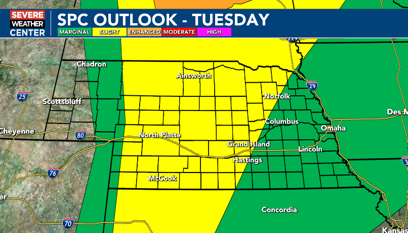
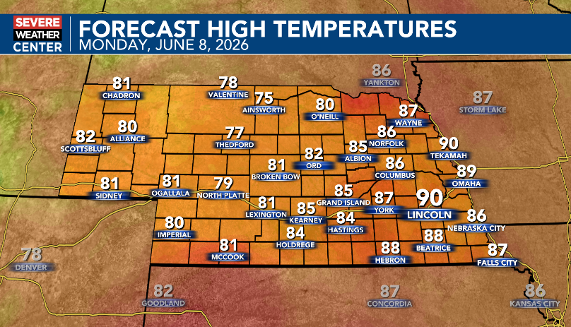
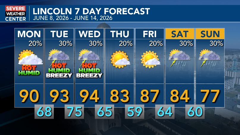
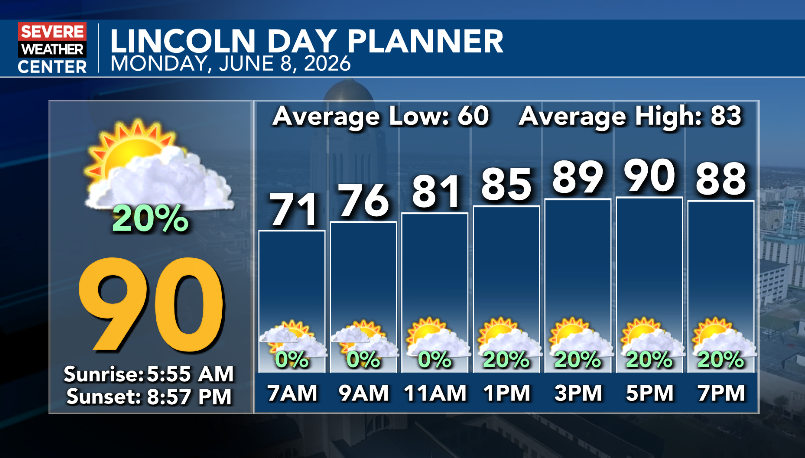
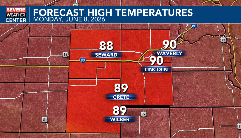
Hot and humid first half of the week, then cooler and potentially less humid second half of the week. Heat index values could reach 100 to 105 Tuesday & Wednesday afternoons. Best chances for showers and thunderstorms are Tuesday, Wednesday and this weekend.
A Severe Thunderstorm Warning has been issued for Custer Co(s) until Jun 08 11:00AM CDT. Large hail, damaging winds, torrential rain, and frequent lightning are possible. For more info, visit https://t.co/VpBhKND6K9 #NEwx
A Severe Thunderstorm Warning has been issued for Buffalo, Dawson Co(s) until Jun 08 11:00AM CDT. Large hail, damaging winds, torrential rain, and frequent lightning are possible. For more info, visit https://t.co/VpBhKND6K9 #NEwx
A Severe Thunderstorm Warning has been issued for Dawson Co(s) until Jun 08 10:15AM CDT. Large hail, damaging winds, torrential rain, and frequent lightning are possible. For more info, visit https://t.co/VpBhKND6K9 #NEwx
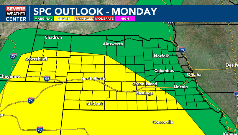
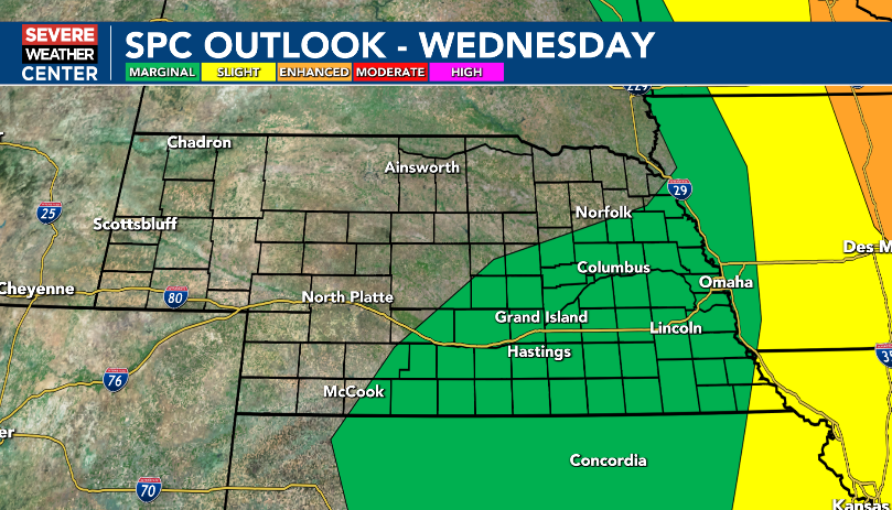
Monday morning update: Isolated to scattered severe thunderstorms are possible in the area Monday, Tuesday and Wednesday. Large hail and damaging winds are the main threats. The tornado threat is low.
7:45am Monday update: Dense Fog Advisory in effect for part of South Central Nebraska until 10am Monday. Visibility one-quarter of a mile or less likely.
Partly to mostly cloudy, hot and humid today. There is a 20% chance of isolated showers and thunderstorms this afternoon and evening. East and southeast winds at 5 to 15 mph.
A Severe Thunderstorm Warning has been issued for Perkins, Keith Co(s) until Jun 08 3:30AM MDT. Large hail, damaging winds, torrential rain, and frequent lightning are possible. For more info, visit https://t.co/VpBhKND6K9 #NEwx
It has been very active over the last 24 hours! Storms yesterday into the overnight hours produced 2 to nearly 5 inches of rain! Lincoln officially only recorded 0.10", but just southwest of Aurora, there was 4.75".
EXTENDED: The Severe Thunderstorm Watch will now be in effect until 2 a.m. Saturday, as we continue to monitor the threat of some hail, gusty winds and flash floods these with late-night storms. #NEwx
A Flash Flood Warning has been issued for Lancaster, Gage Co(s) until Jun 06 1:30AM CDT. Be prepared to move to higher ground and NEVER drive through flooded roadways! Turn around, don't drown! #NEwx#NEwx
A Severe Thunderstorm Warning has been issued for Seward, Lancaster Co(s) until Jun 05 9:30PM CDT. Large hail, damaging winds, torrential rain, and frequent lightning are possible. For more info, visit https://t.co/VpBhKND6K9 #NEwx
A Severe Thunderstorm Warning has been issued for Lancaster Co(s) until Jun 05 9:45PM CDT. Large hail, damaging winds, torrential rain, and frequent lightning are possible. For more info, visit https://t.co/VpBhKND6K9 #NEwx
A Flash Flood Warning has been issued for Saline, Gage, Jefferson Co(s) until Jun 06 1:30AM CDT. Be prepared to move to higher ground and NEVER drive through flooded roadways! Turn around, don't drown! #NEwx#NEwx
A Severe Thunderstorm Warning has been issued for Otoe Co(s) until Jun 05 9:30PM CDT. Large hail, damaging winds, torrential rain, and frequent lightning are possible. For more info, visit https://t.co/VpBhKND6K9 #NEwx
A Severe Thunderstorm Warning has been issued for Lancaster Co(s) until Jun 05 9:15PM CDT. Large hail, damaging winds, torrential rain, and frequent lightning are possible. For more info, visit https://t.co/VpBhKND6K9 #NEwx
A Severe Thunderstorm Warning has been issued for Saline, Gage, Jefferson Co(s) until Jun 05 9:00PM CDT. Large hail, damaging winds, torrential rain, and frequent lightning are possible. For more info, visit https://t.co/VpBhKND6K9 #NEwx