Severe Thunderstorm Warning for Allegany, MD & Others until 8:45 PM EDT. 60 mph wind gusts and damaging winds possible. Move to an interior room on the lowest floor. Watch for downed trees and power outages.
Severe Thunderstorm Warning for Harrison, WV & Others until 8:45 PM EDT. 60 mph wind gusts and 0.75" hail possible. Torrential rain may cause flash flooding. Move to an interior room on lowest floor; don’t drive through flooded roads.
Severe Thunderstorm Warning for Fayette, PA & Others until 9:00 PM 6/14. 60 mph wind gusts and small hail possible. Damage to roofs, siding, and trees. Seek shelter inside a well-built structure and stay away from windows.
Severe Thunderstorm Warning for Calhoun, WV & Others until 8:00 PM 6/14. 60 mph wind gusts and 0.75" hail possible. Torrential rain may cause flash flooding. Move to an interior room on lowest floor; don’t drive through flooded roads.
Severe Thunderstorm Warning for Kanawha, WV & Others until 8:00 PM 6/14. 60 mph wind gusts and radar-indicated severe storms. Expect damage to roofs, siding, and trees. Move to an interior room on the lowest floor.
Severe Thunderstorm Warning for Fayette, PA, Greene, PA, Washington, PA & Others until 7:45 PM EDT. 60 mph wind gusts and small hail possible. Radar-indicated storms. Seek shelter inside a well-built structure; stay away from windows.
Severe Thunderstorm Warning for Doddridge, Harrison, Tyler, WV & Others until 7:30 PM EDT. 60 mph wind gusts and 0.75 in hail possible. Torrential rain may cause flash flooding. Move indoors to lowest floor; don’t drive through flooded roads.
Tornado Watch for Allegheny & Westmoreland, PA until 10 PM EDT. Conditions favorable for tornadoes. Stay alert for Warning updates and be ready to act quickly.
Severe Thunderstorm Warning for Allegheny, PA & Others until 7:00 PM EDT. 60 mph wind gusts and small hail possible. Damage to roofs, siding, and trees. Seek shelter in a well-built structure, stay away from windows.
Severe Thunderstorm Warning for Belmont, OH & Others until 6:15 PM EDT. 60 mph wind gusts and small hail are possible. Radar indicates a line of storms. Seek shelter in a well-built structure and stay away from windows.
Severe Thunderstorm Warning for Marion, WV & Others until 6:00 PM 6/14. 60 mph wind gusts and small hail possible. Damage to roofs, siding, and trees. Seek shelter in a well-built structure; stay away from windows.
Severe T-Storm Watch for Braxton, WV & Others until 9 PM EDT. Conditions favorable for severe storms. Possible damaging winds, large hail, and heavy rain. Monitor for Warnings.
Severe T-Storm Watch for DC & Others until 11 PM EDT. Conditions favorable for severe storms, incl. damaging winds, large hail, and heavy rain. Monitor radar and be ready for Severe T-Storm Warnings.
Severe T-Storm Watch for DC, MD & VA until 11 PM EDT. Conditions favorable for severe storms, incl. damaging winds, large hail, and heavy rain. Monitor for Severe T-Storm Warnings.
Severe Thunderstorm Warning for Braxton, Gilmer, Lewis, and Upshur, WV until 5:00 PM EDT. 60 mph wind gusts and 0.75 in hail possible. Radar-indicated storm near Glenville. Move to interior room; watch for tornadoes.
Severe Thunderstorm Warning for Calhoun, WV & Others until 4:15 PM EDT. 60 mph wind gusts and 0.75" hail possible. Torrential rain may cause flash flooding. Move to an interior room on lowest floor; don’t drive through flooded roads.
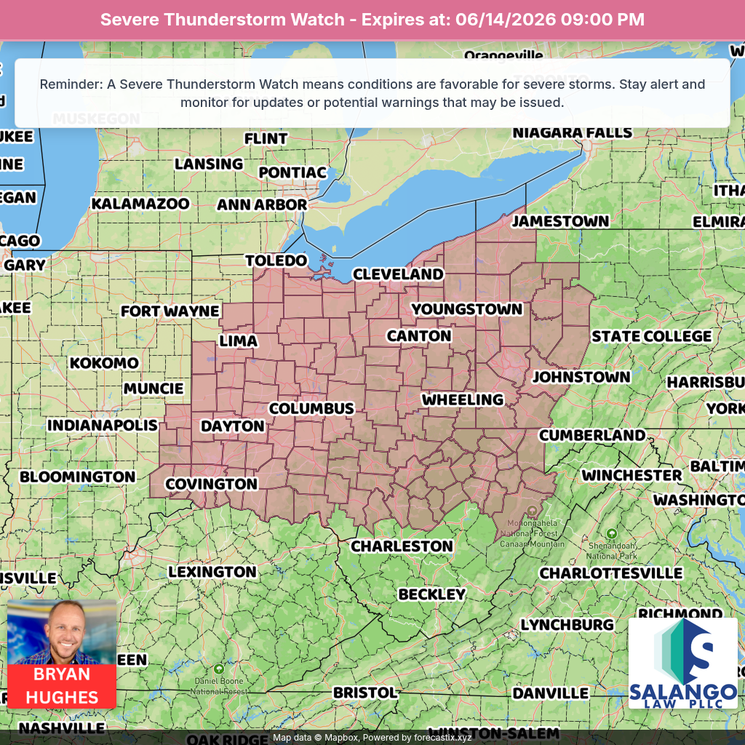
Severe T-Storm Watch for IN, OH, KY until 8 PM. Conditions favorable for severe storms. Damaging winds, large hail, and heavy rain possible. Monitor radar and be ready for Severe T-Storm Warnings.
Severe Thunderstorm Warning for Alleghany, VA & Others until 6:15 PM. 60 mph winds and 1.0" hail possible. Lightning and heavy rain may cause flooding. Move to an interior room on lowest floor of sturdy building; stay away from windows.
Severe Thunderstorm Warning for Alleghany, VA, Bath, VA, City of Covington, VA, & Others until 5:45 PM EDT. 60 mph winds and 1.0" hail possible. Move to an interior room on lowest floor of sturdy building; stay away from windows.