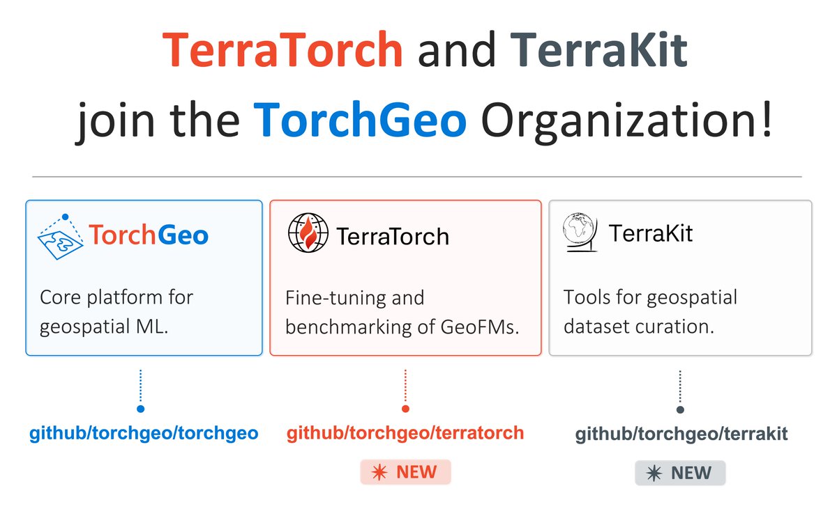
Excited to announce that TerraKit and TerraTorch from @IBMResearch have joined the TorchGeo organization - https://t.co/QG7xBra79v!!
Together with TorchGeo, these python packages provide geospatial ML datasets, foundation models, fine-tuning tools, and more!
@nichm@isaaccorley_ Cool!! Try a _very_ few number of change and no change samples, then iterate (add more samples and retrain) based on where you see the model making mistakes
New post with @isaaccorley_ : DeltaBit -- dense, satellite imagery-based change detection with AlphaEarth embeddings, running entirely in the browser. Check it out at https://t.co/SfPEeZk8YN
This lets users label a few examples of change → train a linear model → see predictions interactively as they scroll around Seattle → download change polygons. No backend services or desktop software needed!
Try it at https://t.co/J2xVu7g64F
This is pt. 3 of our "Compressing Earth Embeddings" series. We:
- Compress per-pixel *differences* between two years of embeddings and store the top 8 PCA components as XYZ GeoTIFF tiles
- Use GeoTIFF.js to decode in-browser
- Use WebGPU compute shaders to train/inference
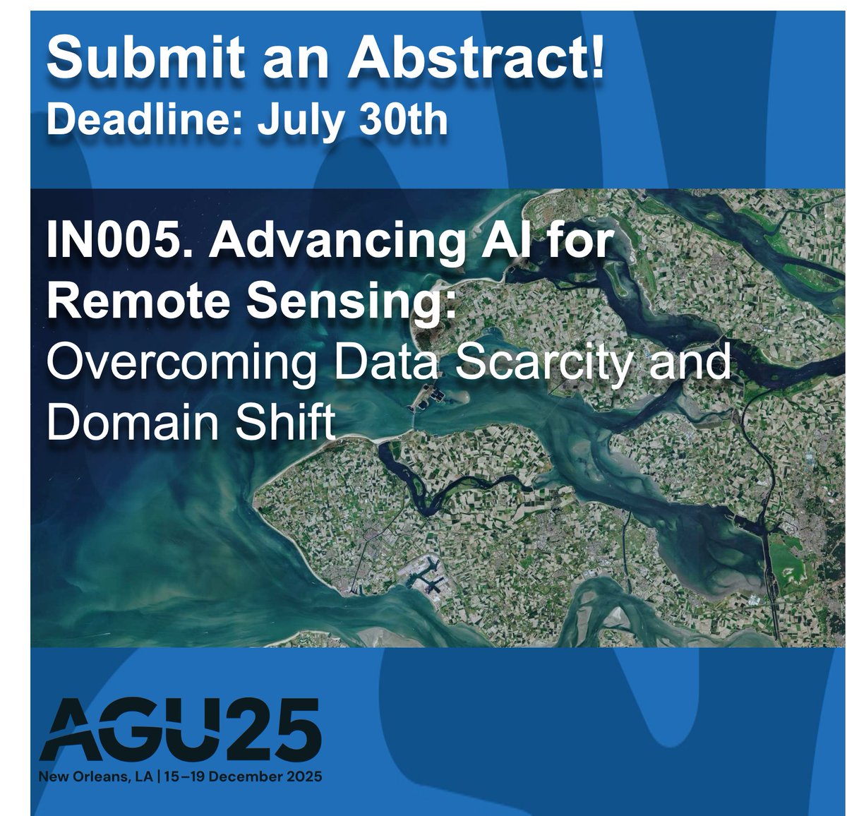
Working on transfer learning and foundation models in remote sensing? We invite you to submit abstracts to our session IN005 at #AGU25 (https://t.co/IeKBxVEJdB…) organized by @sherwang (MIT),@hannah_kerner (Arizona State), Siddharth Sachdeva, and me (Stanford).
Researchers at @Microsoft’s AI for Good Lab, in collaboration with @WildNatureInst, have developed GIRAFFE, an open-source AI-driven system to automate the identification of individual giraffes.
Learn more about our new AI-powered tool. https://t.co/A8h9qSSrwH
I'm hiring for a machine learning data scientist & research assistant for summer 2025!
Join me on a project on invasive species management with an innovative startup doing on-the-ground removal of environmentally destructive invasives.
Paid, full-time w/ possibility to extend.
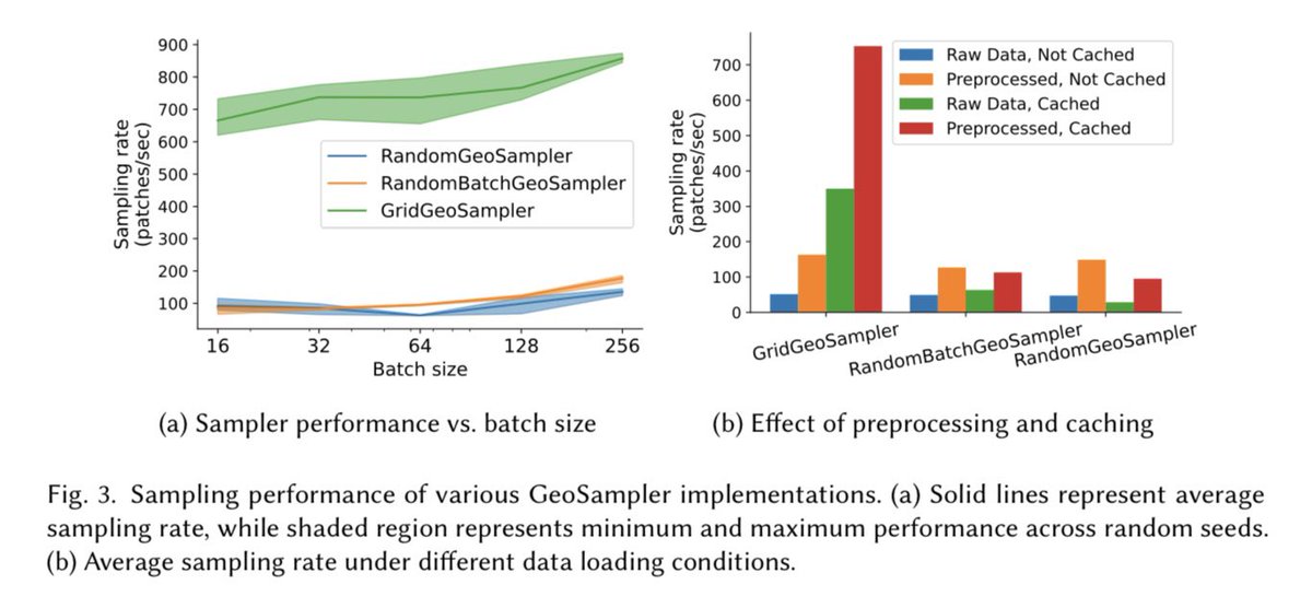
An expanded version of our TorchGeo paper has been accepted to ACM TSAS @TheOfficialACM
In addition to even more benchmarks on remote sensing datasets, we provide a thorough survey of open-source libraries for deep learning for geospatial data
@calebrob6@BDataScientist
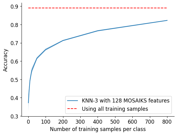
@Ritwik_G Here's a small experiment using MOSAIKS features and KNN-3 (notebook https://t.co/fFWZLu3qlv). Looks like there is some interesting space for showing gains vs. simple methods with few training samples. Would love to see 90+ acc with a handful of examples!
NOAA has posted satellite imagery from the areas affected by the Eaton, Hurst, and Palisades wildfires. The imagery is available through Maxar's Open Data program to support the emergency response community and the public: https://t.co/bpaNy9O8o6
Disaster-specific @FEMA resources are available here: https://t.co/VOF2tudFUk
@yacineMTB@growing_daniel Yes, you can see before/after satellite imagery here https://t.co/fHGvh1aEXx. There are ~2k destroyed buildings visible in this scene
The Climate Change AI workshop at NeurIPS tomorrow will be livestreamed for free, even if you weren't able to register for NeurIPS (which was oversubscribed this year)!
🚨Our new review paper "Better, not just more: Data-centric ML for Earth Observation" 🌐🤖🛰️🔍 has finally been published in GRSM. Shifting the focus from models to data offers new possibilities to improve accuracy, generalization, and real-world impact: https://t.co/jhxOs6vx0P
Joint work with @MarcCoru, Caroline Gevaert, @MKampffmeyer, @jeferssonalex, @MariaVakalopou1, @RonnyHaensch, Stine Hansen, @Keiller, Jonathan Prexl, @devistuia
Arxiv version: https://t.co/KVdwv0CJCt