#EditorsChoice#Review
Spatiotemporal Analysis of NH3 Emission Sources and Their Relation to Land Use Types in the Eastern German Lowlands (Brandenburg University of Technology (BTU) Cottbus, Germany) by @Chrisaravia
https://t.co/8fEjREuXnX
#mdpiatmosphere#emission#ammonia
Visualización de la calidad del aire
Las rayas varían de color para representar una calidad del aire de “aceptable” hasta “extremadamente mala”. Es evidente del deterioro de calidad del aire en #Guatemala.
#airqualitystripes#PM25
EPIC's AirWatch this June that spotlights #CommunityCatalysts from @oafajardom from Colombia, @Chrisaravia from Guatemala and Newton Matandirotya from Zimbabwe brought back some pleasant memories.
Read more: https://t.co/l5fVK5tjHK
@UChiEnergy#CleanAir
#EMSR727
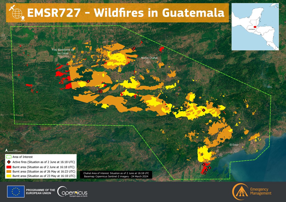
Over the past few weeks, our #MappingTeam has delivered 33 products across 10 AoIs to support the response to the #wildfires 🔥 in #Guatemala 🇬🇹
��️Over 120,000 ha of burnt areas have been detected
Read more at👇
https://t.co/k6Vc0kqd3O
Mexico & Central America experiencing increased fires & smoke pollution in last 2-3 weeks (later than usual late April/early May peak) as shown in #CopernicusAtmosphere organic matter aerosol optical depth analyses from 1 May-9 June https://t.co/W84BwszXfZ @CopernicusECMWF 🧵
Central America is facing an intense wildfire season, which has burned thousands of hectares.
The EU's Copernicus Emergency Management Service aids with rapid mapping for damage assessment, particularly in Belize and Guatemala, which have been severely affected by the fires. ⬇️
#EMSR727#Wildfires in #Guatemala 🇬🇹
Since last night, our #MappingTeam has delivered 2 new Delineation Products and 1 Grading Product
➡️Overall, a total of ~114,310 ha of burnt area 🔥 has been detected
Find more details and updates at 👇 https://t.co/k6Vc0kqKTm
#EMSR727#Wildfires in #Guatemala🇬🇹
Over the weekend, our #MappingTeam delivered 5 Delineation Products, with more products expected soon
As of 2 June
➡️Over 110,000 ha of burnt area has been detected🔥
More at👇
https://t.co/k6Vc0kqKTm
Wildfires in northern Guatemala have burnt an area similar in size to Rome.
The EU is providing damage assessment and emergency mapping, while a Spanish FAST team, deployed by the #EUCivilProtection Mechanism, has arrived to assist authorities.
https://t.co/efcivitJR8
#EMSR727#Wildfires in #Guatemala ���🇹
Overnight, our #MappingTeam has delivered 3 new Delineation Products
➡️Overall, a total of ~99,500 ha of burnt area 🔥 has been detected
Find more details and updates at👇
https://t.co/k6Vc0kqd3O
#EMSR727#Wildfires 🔥 in #Guatemala 🇬🇹
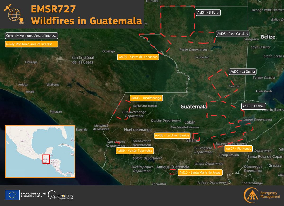
Our #MappingTeam has been tasked to monitor 6 new Areas of Interest
➡️Sierra del Lacandón
➡️La Union Barrios
➡️Rio Hondo
➡️Jacaltenango
➡️Volcán Tajumulco
➡️Santa Maria de Jesús
More updates are coming soon!
🔗https://t.co/k6Vc0kqd3O
#EMSR727#Wildfires in #Guatemala 🇬🇹
Overnight, our #MappingTeam has delivered its Delineation Monitoring Products for all 4 Areas of Interest
As of 26 May:
➡️A total burnt area of +7⃣1⃣,0⃣0⃣0⃣ ha and 40 active fires have been detected 🔥
More at👇
https://t.co/k6Vc0kqd3O
#EMSR727#IncendiosForestales en #Guatemala 🇬🇹
El equipo de @CopernicusEMS ha entregado su monitoreo de delineación para las 4 Áreas de Interés
A partir del 26 de mayo
➡️ Un área total quemada de +71,000 ha y se han detectado 40 incendios activos.
https://t.co/YhT90pA6CS
#EMSR727
Yesterday, our #MappingTeam has been activated to monitor the evolution of multiple #wildfires🔥 which are affecting northern #Guatemala🇬🇹
4⃣ Delineation products have already been delivered
A total burnt area of 30,586 ha has been detected❗️
https://t.co/k6Vc0kqd3O