Nashville International Airport will be changing its name to Dolly Parton International Airport to honor the late Dolly Parton. https://t.co/gy4yReDXYU
4:50 AM ET 9/10/26: Flood Advisory for Lewis, KY & Mason, KY until 7:45 AM ET. Minor flooding in low-lying/poor drainage areas is expected with 1-2 in rain. Turn around, don’t drown when roads flood.
2:35 AM ET 9/10/26: Flood Advisory for Highland and Ross Counties, OH until 6:30 AM EDT. Minor flooding in low-lying and poor drainage areas is expected. Heavy rain has produced 1-2" with more possible. Turn around, don’t drown.
2:00 AM ET 9/10/26: Flash Flood Warning continues for Adams, OH & Others until 7:00 AM 9/10. Life-threatening flash flooding is ongoing/expected; thunderstorms have produced 2-4.5 in rain with more 1-3 in possible. Turn around, don’t drown.
1:28 AM ET 9/10/26: Flash Flood Warning for Adams, OH, Highland, OH, and Pike, OH until 5:00 AM EDT. 1-3 in rain has fallen; more 1-3 in possible. Flash flooding of creeks, streets, and underpasses. Turn around, don’t drown.
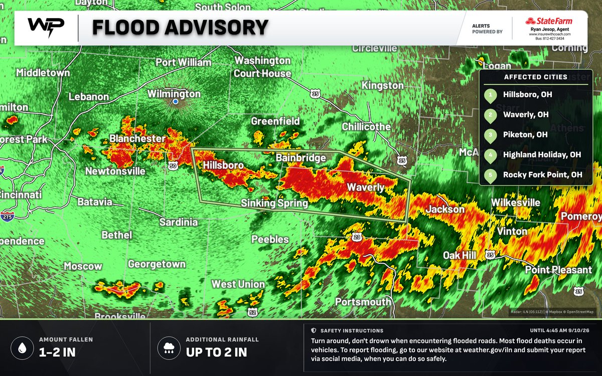
1:16 AM ET 9/10/26: Flood Advisory for Highland, OH & Others until 4:45 AM EDT. Minor flooding in low-lying/poor drainage areas is expected. 1-2 in rain has fallen; up to 2 in more possible. Turn around, don’t drown.
10:01 PM ET 9/9/26: Special Weather Statement for Fayette, Clinton, and Highland until 10:30 PM 9/9/26. Wind gusts up to 45 mph are possible. A strong thunderstorm was near New Vienna moving east at 30 mph. If outdoors, seek shelter inside a sturdy building.
9:39 PM ET 9/9/26: Special Weather Statement for Fayette, Pickaway, and Fairfield until 10:30 PM 9/9/26. Strong thunderstorms may bring wind gusts up to 45 mph, knocking down tree limbs and blowing unsecured objects. Seek shelter indoors.
9:12 PM ET 9/9/26: Special Weather Statement for Greene, Fayette, and Warren until 9:45 PM 9/9/26. Wind gusts up to 50 mph and very heavy rain. Radar-indicated. Seek shelter indoors if outdoors; motorists slow down and use extra caution.
7:56 PM ET 9/9/26: Special Weather Statement for Wayne, Fayette, & Union until 8:30 PM 9/9/26. Strong thunderstorm near Connersville moving E at 35 mph. Wind gusts up to 45 mph may knock down limbs and blow unsecured objects. Seek shelter indoors.
7:18 PM ET 9/9/26: Storms are developing near the cold front this evening from far eastern Indiana into western/central Ohio. A few may produce isolated strong to severe wind gusts before sunset, 55-70 mph. A severe thunderstorm watch is unlikely (20% chance).
2:06 PM ET 9/8/26: Heat Advisory for Scott, Jefferson, Trimble & Others until 8:00 PM 9/9/26. Heat index up to 106 expected. Hot, humid conditions may cause heat illness. Limit outdoor time; drink plenty of water.
9:31 PM ET 9/5/26: Special Weather Statement for Owen and Grant Counties until 10:00 PM 9/5/26. Wind gusts up to 45 mph and pea size hail are possible. A strong thunderstorm was 7 mi W of Dry Ridge moving S at 30 mph. Seek shelter indoors.
8:58 PM ET 9/5/26: Severe Thunderstorm Warning for Boone, KY and Grant, KY until 9:45 PM EDT. 60 mph wind gusts and penny-size hail. A storm was near Patriot moving SE at 25 mph. Move to an interior room on the lowest floor.
8:50 PM ET 9/5/26: Special Weather Statement for Kenton, Grant, and Pendleton Counties until 9:15 PM 9/5/26. Wind gusts up to 40 mph and pea-size hail possible. A strong thunderstorm is moving south. If outdoors, seek shelter inside a sturdy building.
8:49 PM ET 9/5/26: Special Weather Statement for Boone, Kenton, and Grant Counties until 9:15 PM 9/5/26. Wind gusts up to 50 mph and pea-size hail are possible. If outdoors, seek shelter inside a sturdy building.
8:31 PM ET 9/5/26: Special Weather Statement for Dearborn, OH & Others until 9:00 PM 9/5/26. Wind gusts up to 45 mph and pea size hail possible. If outdoors, seek shelter inside a sturdy building.
8:18 PM ET 9/5/26: Severe Thunderstorm Warning for Kenton, KY & Others until 9:00 PM EDT. 60 mph wind gusts and tree/power-line damage possible. A storm is over Independence moving SE at 25 mph. Move to an interior room on the lowest floor.
8:14 PM ET 9/5/26: Special Weather Statement for Brown, Highland, and Adams until 8:45 PM 9/5/26. Wind gusts up to 40 mph. A strong thunderstorm was near Hillsboro moving SE at 25 mph. If outdoors, seek shelter inside a sturdy building.
8:04 PM ET 9/5/26: Special Weather Statement for Ripley, Dearborn, and Boone Counties until 8:30 PM 9/5/26. Wind gusts up to 45 mph and half-inch hail possible. If outdoors, seek shelter inside a sturdy building.