6/18: During the summer, the Gulf of America and the Caribbean Sea are dominated by the Bermuda–Azores High, a persistent subtropical high-pressure system. The circulation around this high produces southerly winds over the Gulf and easterly trade winds across the Caribbean.
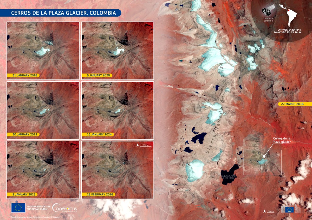
We will never see this glacier again.
@IDEAMColombia has confirmed the extinction of the Cerros de la Plaza glacier in the Andes. Rising temperatures, reduced snowfall, and its relatively low altitude contributed to the acceleration of its retreat.
https://t.co/YCT0qAbe12
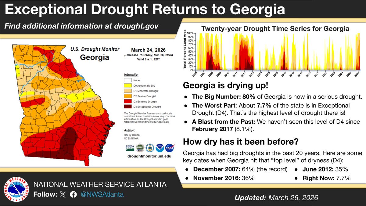
Did you know that Georgia is currently in its worst drought in nearly 10 years? The latest Drought Monitor shows 80% of Georgia in at least Severe Drought. Check out this graphic to see how this compares to other big Georgia droughts in the last 20 years. #gawx#GeorgiaDrought
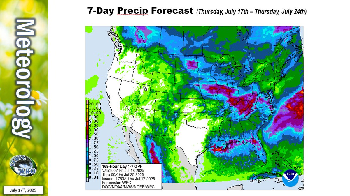
Parts of the Southeast are expected to receive 3-6 inches of rain this weekend bringing a slight risk of severe weather and possible flash flooding. However, chances of river flooding remain limited. Please refer to your local NWS office for updates.
The majority of the Southeast continues to see abnormally dry conditions. Though there is some rain in the forecast due to a passing front, it is expected to provide little, if any, substantial relief to the ongoing #drought conditions.
La Niña conditions are present and favored to persist through December 2025-February 2026, with a transition to #ENSO-neutral most likely in January-March 2026 (55% chance). A #LaNina Advisory is now in effect. https://t.co/5zlzaZ0D9Z
A transition from #ENSO-neutral to La Niña is likely in the next couple of months, with a 71% chance of La Niña during Oct-Dec 2025. Thereafter, La Niña is favored but chances decrease to 54% in Dec 2025-Feb 2026. A #LaNina Watch remains in effect. https://t.co/5zlzaZ1aZx
Streamflow's across most of the Southeast are normal to above normal and normal rainfall is expected for the remainder of the month. Check out our July Water Resources Outlook at https://t.co/BiaM2EB9tg
ENSO-neutral is most likely through the late Northern Hemisphere summer 2025 (56% chance in August-October). Thereafter, chances of #LaNina conditions increase into the fall and winter 2025-26, but remain comparable to #ENSO-neutral. https://t.co/5zlzaZ1aZx
[July 9th]
The leading edge of a large plume of Saharan Dust (as detected by GOES-East) continues moving westward over the tropical Atlantic. This plume will result in hazy skies and deteriorated air quality over PR & USVI later tonight through at least Sunday.
#PRwx#USVIwx
As of 1:30 AM - Conditions continue to gradually improve over Moore County with signs of improvement soon for Orange, Durham, and Alamance counties.
The Haw River is beginning to crest at Haw River and Bynum with a river stage of 31.5 ft and 19.2 ft respectively. #NCwx
We knew this day could come but here we are. The 2026 proposed @NOAA budget shutters all world-class federally funded meteorological, oceanographic, and climate labs in America. Included is @HRD_AOML_NOAA, a fixture for over 50 years in Miami. Hundreds of top scientists tossed.
The official NOAA "budget request" to Congress (which is a detailed version of the "President's Budget" would be devastating, and basically end all research and development.
Purportedly, the proposal moves a lot of weather research and development under NWS, but doing so while eliminating the labs themselves and the CIs would get rid of most of the people and infrastructure that does this critical work.
Fortunately, Congress has the final say on this, so I recommend pressuring your Senators and representatives to step in and continue allocating NOAA the resources to pursue life-saving research.
Over the last week, several large Saharan dust plumes exited the coast of West Africa, entering the skies over the Atlantic Ocean.
On June 4, 2025, a particularly robust, comma-shaped plume began its transatlantic journey (1/3).


![NWSSanJuan's tweet photo. [July 9th]
The leading edge of a large plume of Saharan Dust (as detected by GOES-East) continues moving westward over the tropical Atlantic. This plume will result in hazy skies and deteriorated air quality over PR & USVI later tonight through at least Sunday.
#PRwx #USVIwx https://t.co/VFgzhh7mMs](https://pbs.twimg.com/media/Gvc0nulXIAARj57.png)