Here are the latest Key Messages for the prolonged and dangerous heatwave that is expected to impact the central and eastern U.S. through next week. 🌡️
Guidance at this range has run a touch hot lately, but regardless it’s setting up to be a scorcher to start July next week from the Midwest to the East Coast. 🥵
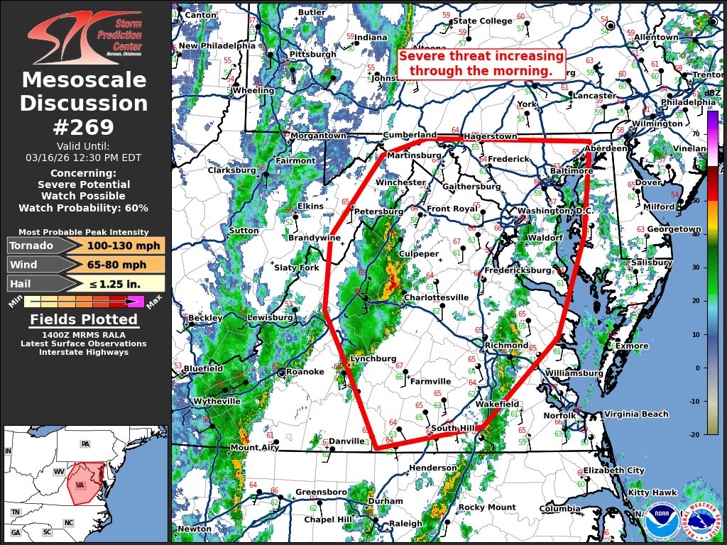
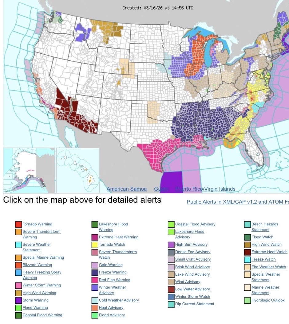
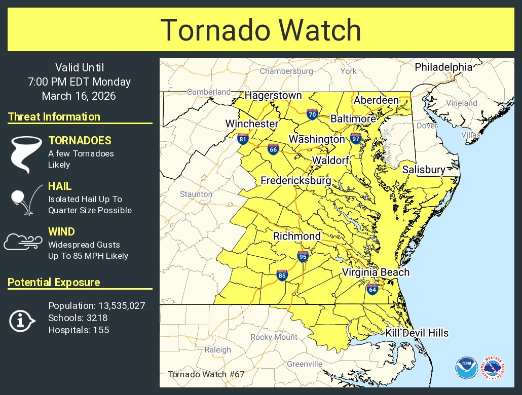
Tornadoes, wind, hail, flooding, blizzard, snow, record heat, and fires across the country at the same time. I’m @NWS_BaltWash today pitching in. Please click on https://t.co/pixR8PIsWh to get the latest life-saving information from the local expertise in your area. Have a game plan to be safe!
@JackRuddenWX@NWS_BaltWash Looking west from New Windsor at 12:05 pm. Looked menacing and had vertical motion but can’t confirm anything more than that.
Nice snowband on the backside of this system currently tracking across TN and AL. Even some snow and sleet being reported as far south as Louisiana!
For Maryland, could see some light snow late tonight and additionally some snow showers most of the day tomorrow. ❄️❄️
FWIW, here's the latest versions of GHCN-D, grabbed today. First plot is stations with CoCoRaHs, second plot is without
Even if you include CoCoRaHS, there's still gaps in SE Mass. And they don't include personal weather stations or LSR's.
From @NOAANCEI, the recent Northeast blizzard given a NESIS category 2 rating, but an RSI category 3 rating.
NESIS: https://t.co/sHryK4FAyU
RSI: https://t.co/GRkqZ115tf
The major nor’easter is coming to an end, here are updated storm reports from the past two days. As of 3 AM EST, the highest snow amount was reported at T.F. Green International Airport (Warwick, RI), with a total of 37.9 inches, which would be the state record if verified.
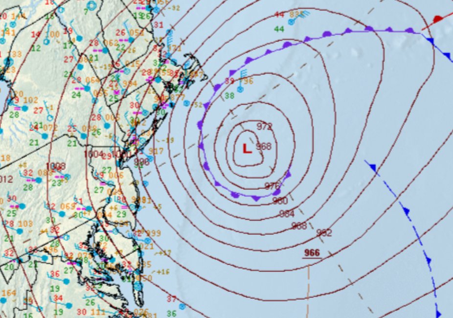
The analyzed central pressure at 7 am EST was 966 mb. This is an estimated 41 mb drop in 24 hours compared to yesterday's analysis at the same of 1007 mb.
@JackRuddenWX Looks like we should have a pretty good idea who’s going to see that 8” wherever this band is at 8 pm. Curious to see how narrow it is though.
The HRRR is very aggressive with this now from south-central PA and maybe as far south as DC. Very interesting to see how it plays out and if very localized totals can exceed 8”.
Some guidance (RGEM here) has depicted an east trend with respect to the inverted trough over central PA and MD. This mesoscale feature could drop 2”/hr snowfall and be relatively slow moving. Can’t emphasize enough that wherever this sets up, forecasts will likely be exceeded.
The Winter Storm Severity Index is an awesome tool that includes social science, climatology, geography, meteorology, and more! This event is a great example of how to contextualize a potentially historic event into individual components and impact levels.
🚨 EXTREME Impacts
The latest Winter Storm Severity Index highlights areas including southeast PA, NJ, Long Island, RI, and southeast MA as having the highest impact level. This means extensive and widespread disruptions to daily life, as well as dangerous or impossible travel.
@JackRuddenWX The southern end of it will likely weaken a bit as it gets tugged towards the bombing low, but I wouldn’t be surprised if it lingers over Carroll County for a bit tonight.
Some guidance (RGEM here) has depicted an east trend with respect to the inverted trough over central PA and MD. This mesoscale feature could drop 2”/hr snowfall and be relatively slow moving. Can’t emphasize enough that wherever this sets up, forecasts will likely be exceeded.