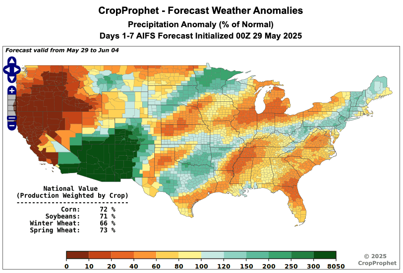
Well, look at that. The EC AIFS weather forecast is now in CropProphet.
The AIFS has emerged as the leading AI-based wx forecast model tracked by commodity traders.
Advance your weather forecast info: https://t.co/YZxWXm3IWe
Using the Point-in-Time Weather Forecast API, we built a forecast-error waterfall. Each row is a forecast initialization date over the last 90 days, each column its valid date, colored by forecast error (forecast minus observed). Here we compare ECMWF and AIFS-ENS 00Z for US corn production-weighted daily precipitation.
Two patterns stand out:
1.On big observed rain events (the tall bars below), both ECMWF and AIFS-ENS under-forecast the total. The red streaks run vertically across all lead times.
2. In dry stretches, both lean slightly the other way and over-forecast, meaning they are not dry enough.
#OOTT #AgWx #AgWeather #Corn #ECMWF #AIFS
We are thrilled to be attending and exhibiting at Commodity Trading Week Americas, co-located with Energy Trading Week Northeast.
CropProphet provides weather intelligence to maximize your grain trading edge. CropProphet helps grain traders quantify weather-driven yield and production risk, track changing crop expectations, and make faster, more objective grain market decisions.
Josh Nagelberg looks forward to connecting with grain traders and commodity market participants at the booth to discuss how CropProphet can support weather-based trading decisions.
Stop by our booth to connect with Josh Nagelberg (look for the CropProphet logo)!
You can also schedule a meeting with Josh here:
https://t.co/OGbc2gEzpg
#CommodityTradingWeekAmericas #EnergyTradingWeekNortheast #CommodityTradingWeek #EnergyTradingWeek #CommodityTrading
Which forecast model has been more accurate recently?
For 7-day averaged U.S. corn production-weighted precipitation, AIFS-ENS has generally had the lowest RMSE in recent initialization dates, with the clearest advantage in the 1-7 day lead range. In the 8-14 day range, AIFS-ENS has also been competitive recently, though model performance is more variable at longer lead times.
There is a notable difference in the 14-day precipitation forecasts for U.S. corn-producing regions among the ECMWF, GEFS, and AIFS models.
The ECMWF and GEFS forecasts indicate above-normal/normal U.S. corn production-weighted precipitation over the next two weeks, while the AIFS forecast indicates below-normal precipitation.
ECMWF: 116% of normal
GEFS: 100% of normal
AIFS: 88% of normal
#oott #AgWx #AgWeather #Corn #AIFS #ECMWF
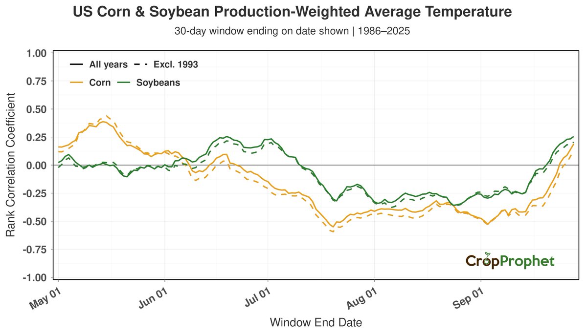
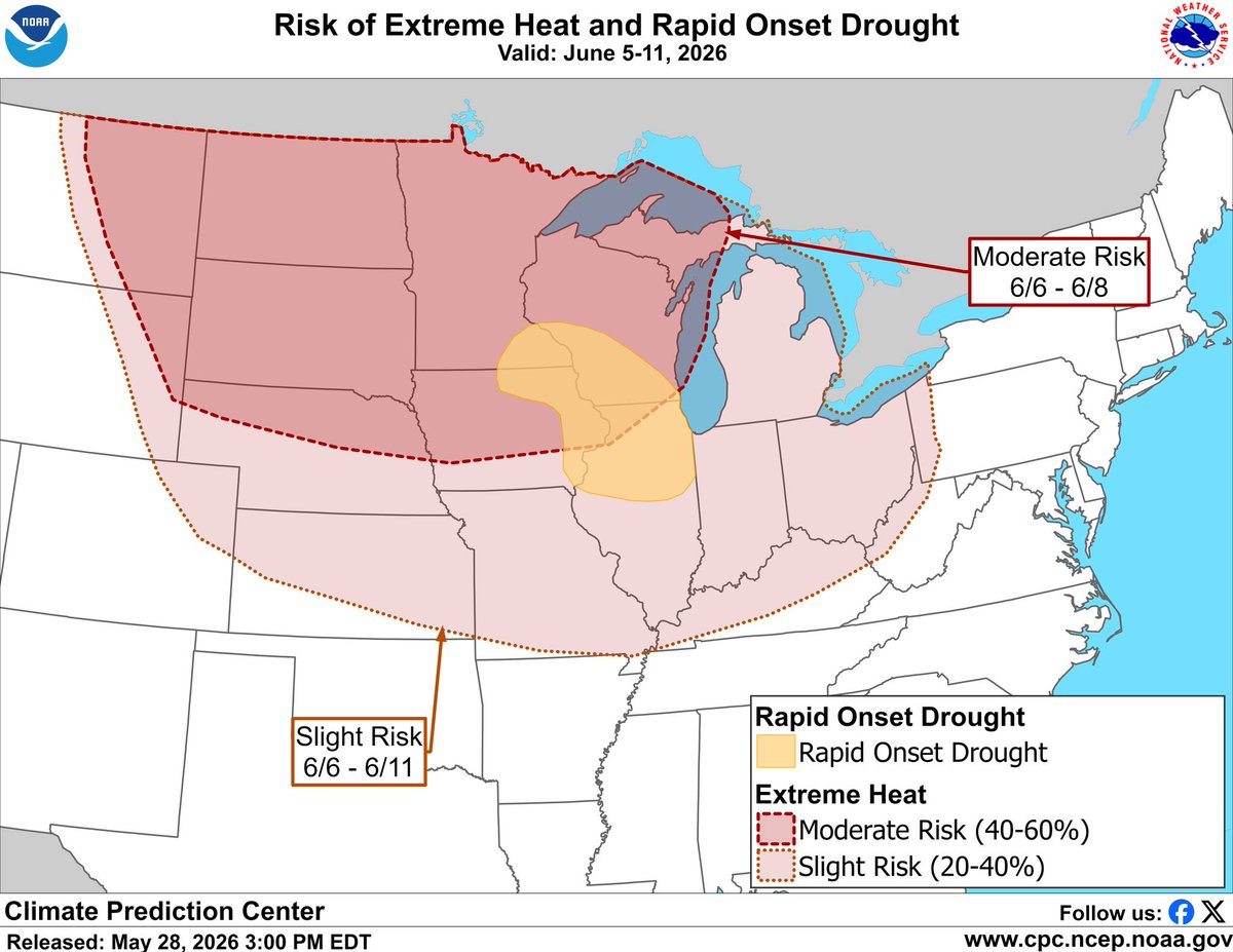
NOAA's Climate Prediction Center flagged a moderate risk of extreme heat with a Rapid Onset Drought risk designated across portions of the central Corn Belt for June 5-11.
This may not be bad news for corn yields right now. CropProphet's 1986-2025 analysis (rank correlation of the 30-day production-weighted average temperature vs. end-of-season corn yield, plotted by window end date) shows the relationship is positive for windows ending in May through early June, roughly neutral for windows ending mid-to-late June, then turns sharply negative for windows ending in July, when heat becomes a clear yield drag.
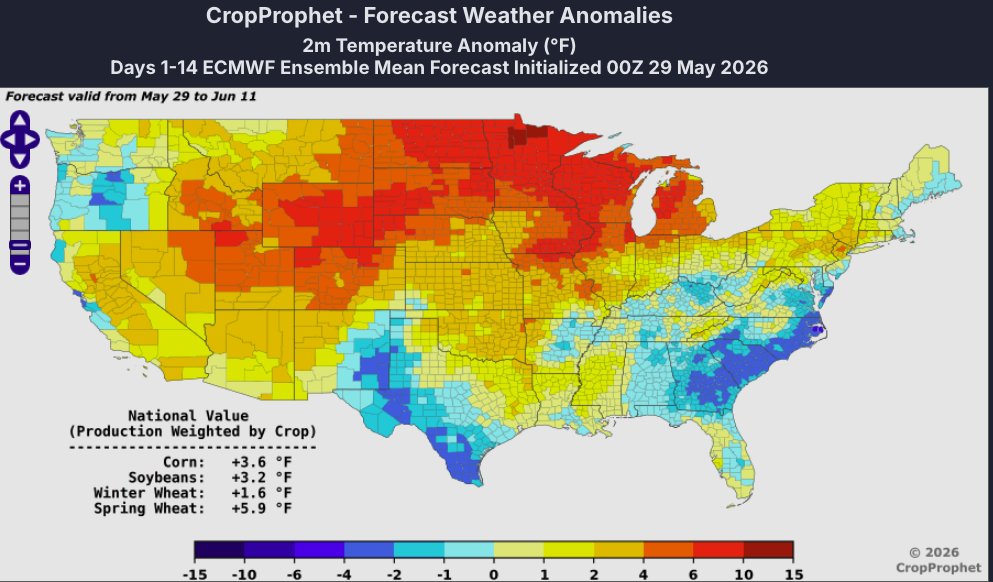
Today's 00Z 14-day ECMWF and AIFS forecasts show above-normal US corn production-weighted average temperatures of +3.6°F and +5.3°F respectively.
Heat in May/early June and heat in July are not the same story for corn.
#OOTT #Corn #Ags #Wx #AgWx #AgWeather #CPC
NOAA's Climate Prediction Center flagged a moderate risk of extreme heat with a Rapid Onset Drought risk designated across portions of the central Corn Belt for June 5-11.
This may not be bad news for corn yields right now. CropProphet's 1986-2025 analysis (rank correlation of the 30-day production-weighted average temperature vs. end-of-season corn yield, plotted by window end date) shows the relationship is positive for windows ending in May through early June, roughly neutral for windows ending mid-to-late June, then turns sharply negative for windows ending in July, when heat becomes a clear yield drag.
Today's 00Z 14-day ECMWF and AIFS forecasts show above-normal US corn production-weighted average temperatures of +3.6°F and +5.3°F respectively.
Heat in May/early June and heat in July are not the same story for corn.
#OOTT #Corn #Ags #Wx #AgWx #AgWeather #CPC
How does this current dryness in the Corn Belt impact end-of-season corn yield?
The historical record shows a clear seasonal shift: precipitation correlations with end-of-season corn yield are weak and near zero through May and the first half of June, then strengthen and flip to a clearly positive relationship by late June and into July, when drier conditions become unfavorable.
This is consistent with the agronomic view that warmth and dryness in May and early June can encourage deeper root development, leaving the crop more resilient to mid-summer heat and drought, while pollination-window moisture is what the yield outcome is most sensitive to.
#oott #AgWx #AgWeather #Corn #CornBelt #Drought
The ECMWF has trended drier since its last run. As a result, all forecast models now show below-normal precipitation across the US corn and soybean production-weighted regions over the next 1 to 14 days.
#oott#AgWx#AgWeather#Corn#Soybeans
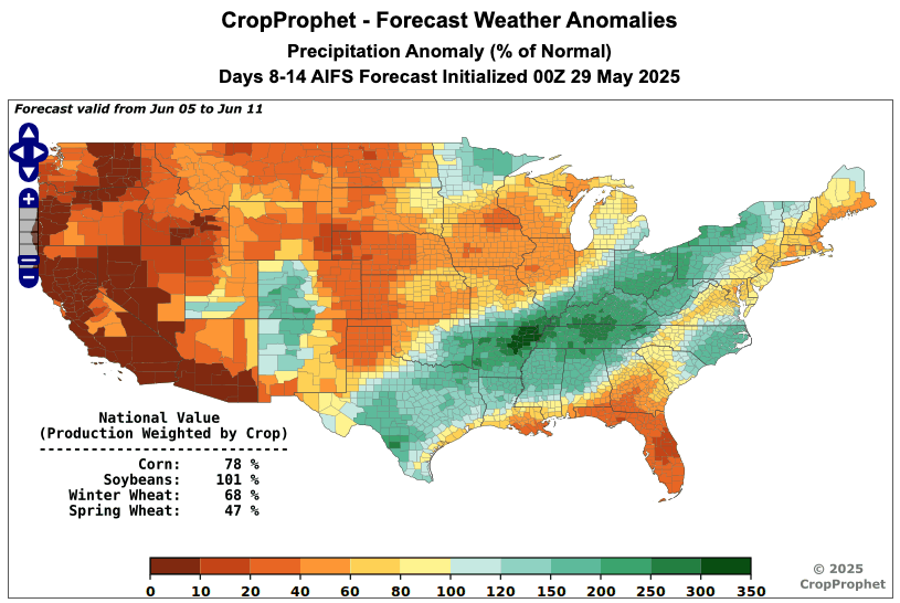
The 14-day forecast is drier than normal, but the 8-14 day forecast between models shows a different story.
Today's 00z ECMWF 8-14 day US corn production-weighted precipitation is 101% of normal, while the AIFS and GEFS both forecast below normal precipitation.
Tomorrow's 00z forecast will be interesting to see...
#ooatt #AgWx #AgWeather #Corn
France, Europe's top wheat grower, has faced extreme heat over the past week, and the heatwave is not over.
Over the next 7 days, France is forecast to see the heat wave broaden further, with maximum temperatures running as much as 8.7°C above normal (15.7°F).
#Wheat#France #Europe #Heat