Meteorologist for Crown Weather specializing in Tropical Storm & Hurricane forecasting. I also cover Western & Central Mass weather with Route 20 Weather.
GOES-19 update: Engineers are making progress in recovering GOES-East and are ready to start recovering instruments. Currently it is looking like sometime just after Noon EDT. After that they will begin working on the lightning mapper. It can't come soon enough! #mewx
This is really, really bad & it does impact all of us in the weather industry to do our jobs effectively.
I have been using GOES-18/GOES-West to look at satellite imagery as it does cover as far east as the Maine-New Brunswick border. That said, the quality of the imagery isn't sharp due to the angle the satellite is looking at. https://t.co/CYmDqzenOA .
NESDIS engineers are continuing efforts to recover GOES-19. All GOES-19/GOES-East products are currently unavailable. There is currently no estimated restoration time. #MEwx
@TerryWBZ While not the quality of GOES-19, the GOES-18 satellite is able to view as far east as New England. Been using that angle this morning since our main satellite went down yesterday. https://t.co/LoSk8olRAT .
@weatherdak Not sure if will work for you. Before picture was taken after a snowfall in late January. After picture was taken in the same spot today with smoke conditions at all levels of the atmosphere. Taken in Sturbridge, Mass.
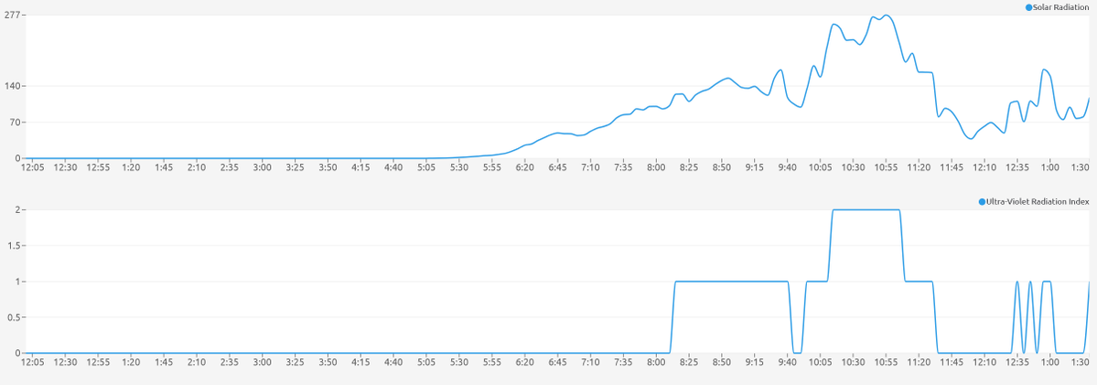
@WX1BOX@JimCantore@1DegreeOutside Smoky skies and the smell of smoke is prevalent here in Sturbridge. Solar radiation measurement dropped as low as 37 w/m2 at 12 pm. #mawx
Mount Washington,NH (MWN) ASOS reports gust of 72 knots (82.9 mph) from W @ 0142Z -- KMWN 150147Z 28041G70KT 0SM TS RA FG VV000 13/13 RMK PK WND 28072/42 CONS LTGICCG OHD SHGRB39E43 TS OHD MOV SE GR 1/2
@BradyBGWX Severe weather potential for those parts makes feel ill. There are A LOT of folks camping in the northern Greens and White Mountains & may not be completely aware of the possible severe weather. Ugh.
@SCweather_wx Extremely dangerous weather situation for an area that I've spent a lot of my life camping in. Heavily forested that's now teeming with people camping and vacationing that may not be paying attention.
Here are some unsolicited thoughts - In terms of terrain out of the 3 northern New England states, I'd travel up where I used to live.....Aroostook County, Maine (lived there for 26 years & did do some chasing) & more specifically US-1 from Houlton to Van Buren. There is a lot of open farm fields that'll give you some nice views in all quadrants. Definitely stay away from the mountain areas of W Maine, Northern NH & N Vermont. More trees than anything would put you in a really dangerous sit. If you do travel to NH, go way up near the tippy top by the Canadian border. Things open up into more fields once you get north of the US-2 corridor, especially up by Pittsburg.
Here in the NE US, I could easily foresee something like a 97-98 type winter. To me, I think ice storms rather than snowstorms could be the bigger threat, esp. well away from the coast in Southern New England & across Northern New England/SE Canada. Most of the snow this winter could be frontloaded w/ the ice threats showing up in Jan/Feb. JMHO.
Yeah, I definitely have my ears perked for this hurricane season in terms of a NE US impact. New England & the NE US tends to be impacted directly during low number seasons. Likely due to the fact that in-close development & little MDR activity occurs in those seasons. I do think that if we get hit here in Southern New England this year, it'll occur in August rather than Sep or Oct.
An additional doppler radar station or two that covers the entire Connecticut River Valley would be a huge help in the summer. Will it ever happen? Probably not. For instance, the Connecticut River here in Mass is vastly not covered by radar. Both Albany and Boston's radar sites miss much of the velocity data of storms coming off of the Berkshires and pushing into the Valley. This is a huge deal as radar data misses the Springfield metro. Makes figuring out the severity of a thunderstorm very difficult.
And as you know, there have been some notable Long Island-Southern New England hurricanes in August. You mentioned 1991's Bob, but also 1635 Great Colonial Hurricane occurred in late August & followed a pretty similar path to Bob. A not too mentioned 1893 hurricane went partially up the lower Hudson before turning NE & traveling across Western & Northern New England. That was also in late August.
@4cast4you Heard them, couldn't see them w/ trees blocking my view here in Sturbridge. I actually thought they were the F-35's they just got recently at Westfield until I saw your post.
@WX1BOX@NWSBoston@DHTheWeatherNut@BradyBGWX Interesting. Allen Road is north of Route 20 & where I live, Shepard Road is south of Route 20 & off of Route 131, almost near the town line with Southbridge.