A book on ‘Remote Sensing for Geophysicists’ has been published by the CRC Press. In this book, I have tried to integrate modern remote sensing technologies with the geophysical methods used for the investigation and exploration of earth resources. https://t.co/SmwnNDbdRc
It is impossible to project a globe onto a sheet of paper without compromise. Distances, areas, directions and angles cannot all be preserved at once. Something must be sacrificed when three dimensions are forced into two.
Hence, there is nothing improper about preferring one map projection over another.
But the quarrel over the Mercator projection soon becomes identity politics. And so it inherits every vice of that style of argument: it is anachronistic, reductionist, and charged with unspoken insinuations about colonial guilt and the inherited sin of white people.
The Mercator projection of 1569 was a stroke of genius for the purpose it was meant to serve.
Mercator’s map was a navigational instrument. Its decisive property was that it rendered directions and angles truly: a line of constant compass bearing appears as a straight line.
To secure that property, a faithful representation of area had to be given up. But as already said: one cannot have everything when a sphere must be drawn as a plane. One has to choose.
It is therefore almost intolerable to hear the insinuation that Mercator was some kind of racist, intent on striking Africans with an inflated Greenland.
We should honour Gerardus Mercator for what he was: one of the great cartographers in the history of the craft.
The author of a projection whose charts, for centuries, helped generations of seafarers across the open ocean - long before longitude could be determined with any reliability at sea.
Clarification regarding media reports on concerns relating to Space Sector Reforms and the role of ISRO
ISRO’s Next Chapter: Leading India’s National Space Ecosystem
There has been considerable reporting in parts of the media around the future role of ISRO including speculations and misinformation that there is an attempt to privatise ISRO or reduce its role. These assertions are completely baseless and incorrect.
We wish to categorically state that ISRO will neither be privatised nor will its importance be diminished.
ISRO will continue to remain India’s principal institution for advanced space research and technology development, national and strategic missions, space science and exploration, and critical and frontier space capabilities.
Participation of private sector in space is not about reducing ISRO’s role. It is about enabling ISRO to focus even more strongly on the next generation of India’s space programme, while industry scales mature technologies and capabilities. What is changing is not the importance of ISRO, but the scale and structure of India’s space ecosystem.
Towards an ISRO-Led Space Ecosystem
The space-sector reforms initiated since 2020 and institutionalised through the Indian Space Policy 2023, along with progressive liberalisation of FDI policy, aim to create a larger, stronger and globally competitive Indian space ecosystem.
Industry, start-ups and academia are being enabled to participate across the space value chain, complementing and multiplying ISRO’s capabilities. The reforms should therefore be seen as ecosystem expansion and capability multiplication, not privatisation.
As India’s industrial and technological capabilities have grown, mature and scalable activities can increasingly be undertaken by Indian industry. ISRO has already transferred around multiple technologies to industry. Transferring a mature technology does not mean ISRO is withdrawing from that domain.
It enables large-scale production, commercialisation, innovation and access to global markets while allowing ISRO’s scientific and technical manpower to concentrate on advanced research, next-generation technologies and complex national missions.
The transition is therefore towards an “ISRO-led national space ecosystem.”
ISRO’s Focus Will Move Further Towards Frontier Technologies
ISRO’s role will progressively strengthen in areas where its scientific expertise matters most: frontier R&D, advanced technologies, human spaceflight, next-generation launch systems, deep-space and planetary missions and strategic national capabilities.
It will continue developing cutting-edge technologies, including advanced payloads for communication, navigation and Earth observation, sensors, propulsion systems and other critical technologies.
Meanwhile, mature and routinely manufactured systems can increasingly be scaled through industry. Production of mature launch vehicles, routine satellites and other established systems can increasingly be undertaken by industry or PSUs through appropriate competitive processes.
This allows ISRO to devote more resources and scientific manpower to the next generation of technologies and missions, while the wider ecosystem provides the investment, manufacturing capacity and scale required by an expanding national space programme.
Seismic Intensity Map of the seismic event in Tibet resulting in an ice-rock avalanche & glacial lake outburst flood (GLOF) in Nepal.
Magnitude: 4.9
Origin Time: 2026-08-26 08:22:20 (IST)
Lat, Long: 28.386, 85.590
Depth: 0 km
Source: National Center for Seismology, India
Congratulations to the entire Skyroot Aerospace Team on the successful launch of Vikram-1 (Mission Aagaman) from the Satish Dhawan Space Centre, Sriharikota.
The mission marks a significant milestone for India’s private space sector and reflects the growing capability of the country’s space ecosystem.
Congratulations to IN-SPACe and ISRO teams, who enabled and facilitated the launch and ground testing operations along with technical consultancy and 24x7 safety surveillance.
This achievement is also a testament to the Space Sector Reforms envisioned by our Hon’ble Prime Minister Shri Narendra Modi ji.
#Vikram1
#IndiawithVikram1
#SkyrootAerospace
#OpeningSpaceForAll
Hello space, we have arrived! Vikram-1's Test Flight-1 has completed it's mission.
The first ever Indian private sector launch has been successfully completed.
#Vikram1#MissionAagaman#OpeningSpaceForAll
A historic new frontier for India’s space journey!
At 11:30 AM today, Skyroot Aerospace will undertake the maiden orbital launch of Vikram-1, India’s first privately developed launch vehicle.
This four-stage rocket is designed to provide rapid and on-demand launch services. This mission highlights the talent, determination and entrepreneurial spirit of our youth. It also shows how our space-sector reforms are unlocking new opportunities for innovation and enterprise.
My best wishes to the entire Skyroot Aerospace team for a successful launch. May Vikram-1 soar high, create history and inspire a generation of innovators.
I urge all Indians, especially my young friends, to follow this historic mission and join in wishing Team Skyroot success using #IndiaWithVikram1.
@SkyrootA
🌧️ Monsoon Update!
The onset of Southwest Monsoon over Kerala is likely around 26th May 2026 (± 4 days).
Conditions are becoming favourable for further advance of the monsoon over parts of the south Bay of Bengal, Andaman Sea & Andaman and Nicobar Islands during the next 24 hours. 🌊☁️
Stay tuned for latest monsoon updates and weather advisories. ☔🌴
#Monsoon2026 #SouthwestMonsoon #KeralaMonsoon #WeatherUpdate #MonsoonArrival #IMD #RainAlert #Andaman #WeatherNews
@moesgoi@airnewsalerts@DDNational@ndmaindia@ICRER_MHA
Indian Institute of Technology Roorkee continues to advance climate science and open research through INDRA-CMIP6, a high-resolution open-access climate projection dataset developed by researchers from its Department of Hydrology.
Published in Scientific Data (Nature Portfolio),
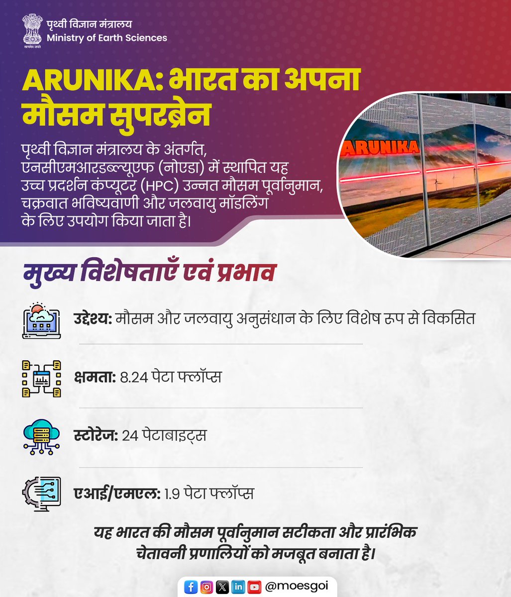
ARUNIKA, पृथ्वी विज्ञान मंत्रालय के अंतर्गत भारत का उन्नत मौसम सुपरकंप्यूटर, देश की पूर्वानुमान क्षमता को मजबूत बना रहा है।
नोएडा स्थित @ncmrwfmoes में स्थापित यह प्रणाली सटीक मौसम पूर्वानुमान, चक्रवात ट्रैकिंग और जलवायु मॉडलिंग में सहायक है।
उच्च क्षमता, तेज़ प्रोसेसिंग और AI/ML तकनीकों के साथ, ARUNIKA भारत की प्रारंभिक चेतावनी प्रणालियों को सशक्त बनाते हुए देश को अधिक सुरक्षित और तैयार बना रहा है।
#MoES #NCMRWF #ARUNIKA
@narendramodi@mygovindia@PMOIndia@DrJitendraSingh@OfficeOfDrJS@PIB_India@PIBEarthScience@MIB_India@Ravi_MoES
Strongly recommended app 'SAMUDRA APP' by INCOIS. It provides real-time updates of various critical geophysical parameters of coastal and oceanic areas.👏💯
क्या आपने SAMUDRA App डाउनलोड किया? 🌊📱
समुद्र से जुड़े हर जरूरी अपडेट अब आपकी उंगलियों पर। मौसम की सटीक जानकारी, मछली पकड़ने के संभावित क्षेत्र, और महासागर से जुड़ी महत्वपूर्ण सलाह, सब कुछ एक ही प्लेटफॉर्म पर।
यह ऐप खासतौर पर मछुआरों और समुद्री उपयोगकर्ताओं को सुरक्षित और बेहतर निर्णय लेने में मदद करता है।
आज ही SAMUDRA App डाउनलोड करें और स्मार्ट बनें, सुरक्षित रहें। 🌍✨
https://t.co/nbe5AM4tLG
#MoES #SamudraApp #INCOIS
@narendramodi@DrJitendraSingh@PIBEarthScience@PIB_India@mygovindia
Alert!
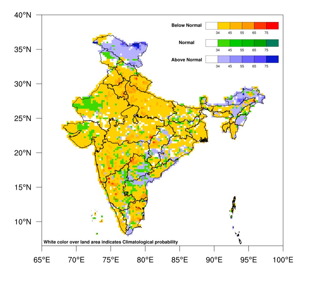
The India Meteorological Department (IMD) issues a BELOW NORMAL (approx. 80 cm) forecast for the 2026 Southwest monsoon Season (June–September) rainfall over the whole of India. https://t.co/7XY33NBZeH