Want to unlock the potential of Geospatial data? Join us at @UniofExeter on this new, innovative and transformative MSc: Geographical Information Science @ExeterGeography https://t.co/XraCXhUsSj
What a year it has been... looking back at the first GIS MSc cohort... congratulations to our graduates who have gone on to work in the GIS industry for Esri UK, RNLI, Wessex Water., University of Exeter
https://t.co/zpyhnW8OM8
Thanks to Ordnance Survey survey team at #Carto24@BCSmaps for leading a hackathon. Our team were tasked to create a tool to build resilience / planning for flooding in Worcester. We enriched OS road network data with Environment Agency flooding risk data to create an app #GEOVIZ
It was an absoulte thrill to host the @ExeterGeography GIS meeting at @esriuk conference. Our meeting was made up of @Exalumni form every year over the past 10 years, current BSc and MSc GIS finalists. Thanks @addy for your support #EsriUKAC thanks attendees for the inspiration!
Inspiring talk at #EsriUK on National Education Nature Park. Create the world you want to see with GIS , nice one @geogologue 👏 https://t.co/lU1wRMwIkT
Great student presentations from @ExeterGeography students on solar potential dashboards, they essentially did what we saw in the opening plenary! Amazing, reps to @DamienMansell and team for setting them off on data driven dashboards
My main spatial dilemma today is wanting to be in 2 places at the same time. Impossible but if you use the stairs you can try…. @DamienMansell @UniofExeter students presenting their work at #esriUKAC
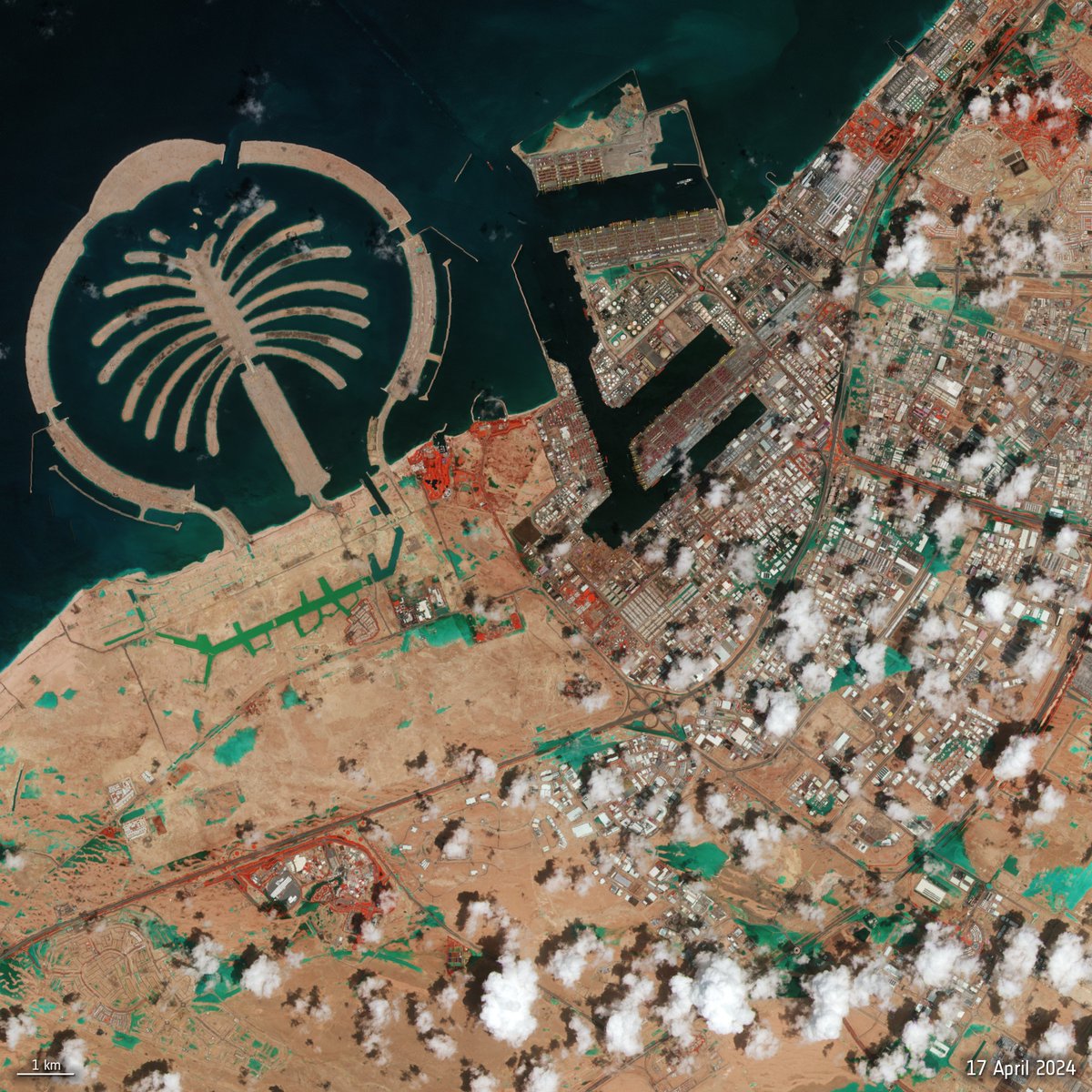
A @CopernicusEU#Sentinel2 image of #DubaiFlooding - captured yesterday 17 April.
It's a false colour composite which highlights flooded areas in turquoise.
Red patches in the image indicate vegetation.
Click on the link below to explore this image at its full 10 m resolution: https://t.co/zEUnEF5UOg
Gepatschferner (Kaunertal, Austria)
2020 | 2023
Disintegration of the frontal area of the 2nd largest Austrian glacier during last four summers (incl. 2 hottest on record)🥵📈
Video @S_Haselberger
If you are at #THEdigitalUK today, you are welcome to stop by my showcase during refreshment breaks to discuss Digital Twins using #GIS to discover how MSc students are using drone imagery to construct 3D models for analysis and geovisualiaation. Thanks @GIS4HE for your support
@yohaniddawela Thanks for sharing I am also a fan of data camp.
I have shared some geospatial lessons on my YouTube account too and welcome feedback as I am looking to grow these resources https://t.co/fJzGdJZ2jM
'Failure' is such important step in learning. (Though I think the meaning of the word failure falls on a spectrum, dependent upon context e.g. from exploration, inattention, inability, process inadequity, task complexity to uncertainty). Great perspective here from climbing.
UK-based academic? Interested in the use of TV and/or radio in your teaching or research? This forthcoming free webinar "How the use of multimedia enhances teaching, learning and research" will offer some practical tips and suggestions https://t.co/g5KzFGlI4w
@GIS4HE@0mgould@ExeterGeography Haha, thanks Addy, it was a pleasure for me and the @ExeterGeography department to learn form you yet again. If I am the lighthouse can you be the foghorn telling everyone about our new GIS MSc course 📢 https://t.co/O9WnJMKV0K #GISchat 😀