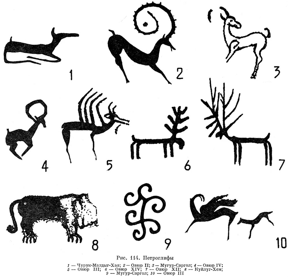
Sayan-Altai petroglyphs. Various animal and symbolic figures. The source of this drawing is the book Ancient Nomads in the Center of Asia, written by Soviet archaeologist Aleksandr Danilovich Grach (А. Д. Грач) and published in Moscow in 1980 by Nauka Publishing House.
According to the Russian notes beneath the image I've shared, these petroglyph copies are listed as being compiled from specific archaeological sites in Tuva, including Churuk-Maldyg-Khaya, Övür, Mugur-Sargol, and Kuylug-Khem. Most of the drawings were gathered from M.A. Devlet's systematic research.
The Sayan-Altai petroglyphs aren't the product of a single culture or era. Over thousands of years, successive communities have left their marks on the very same rocks. In the words of archaeologist Marina Kilunovskaya, each newly arrived civilization marked its presence here--and it didn't destroy the works of its predecessors.
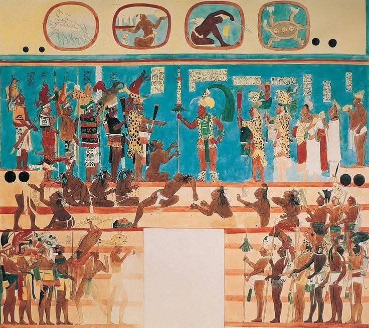
The Bonampak Wall Frescoes ("Painted Walls"), located in the Mayan city of Bonampak in Chiapas, Mexico, are among the best-preserved and most detailed murals of the Mayan civilization.
Dated approximately 790–792 AD (late Classic period), they were commissioned during the reign of Chan Muan (Yajaw Chaan Muwan), the ruler of Bonampak, to depict his son's proclamation as heir to the throne, a military victory, and sacrificial ceremonies.
Location: A small, three-room structure called the "Temple/Mural Temple" (Structure 1). The walls, including the ceilings, are completely covered in frescoes (approximately 140–150 m²).
Introduced to the modern world in 1946 (by Giles Healey, guided by Lacandon Maya). Local Lacandons were already aware of them.
Significance: They shattered the image of the "peaceful, tranquil Maya" that persisted until the mid-20th century; It clearly depicted war, human sacrifice, and blood rituals. It is a unique document of Mayan court life, costumes, musical instruments, and weapons.
Created around 790 AD and discovered in 1946, it is one of the world's most important ancient frescoes, showing Mayan warfare and ceremonies in colorful and brutal detail.
#archaeohistories
Comparto una olla-tambor usada por los mexicas durante el posclásico tardío. Su parte superior estaba cubierta con un cuero, y dentro estaba llena de agua. Los golpes hacían el agua moverse y causar sonidos armónicos entre el golpeteo del agua y la vibración del cuero. Noten la representación solar y las dos aves que la decoran, así como la franja de plumas. Museo Nacional de Antropología
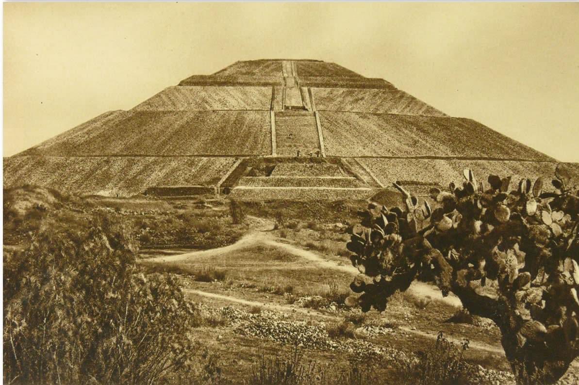
#Sabíasque en 1971 arqueólogos mexicanos descubrieron un túnel debajo de la Pirámide del Sol? El túnel se prolonga horizontalmente 102 m hacia el oriente, debajo del gran templo, y tiene 11 m de profundidad. El túnel fue hecho por manos humanas y posiblemente fue una tumba para los gobernantes teotihuacanos o altos dignatarios. Termina con 4 cámaras, posiblemente una representación de la flor de cuatro pétalos, símbolo que pudo ser el emblema de la ciudad durante su apego.
Tezcacuitlapilli o disco de turquesa.
La pieza fue localizada en la Casa de las Ajaracas, predio que se encuentra sobre la Etapa VI del Templo Mayor de Tenochtitlan. Fue elaborado con 15000 teselas de turquesa. Representa a siete personajes, entre ellos el dios Huitzilopochtli.
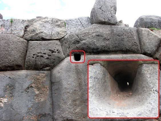
🪨 A Tiny Hole in a Giant Stone… But Its Purpose Still Mystifies Experts
At first glance, it looks like nothing more than a small hole carved into a massive stone wall. But when you realize where it is—and who built it—it suddenly becomes far more fascinating.
This mysterious feature can be seen inside the massive stone walls of Sacsayhuamán, an ancient fortress located high above the historic city of Cusco in Peru. The structure was built in the 15th century by the powerful Inca civilization, a society famous for its incredible engineering skills.
Sacsayhuamán itself is legendary. Its enormous stones—some weighing more than 100 tons—fit together so perfectly that even a thin blade cannot slide between them. No cement. No mortar. Just pure precision. Even modern engineers are still amazed by how these stones were cut and assembled with such perfection.
But hidden within one of these gigantic blocks is something unusual: a small carved opening that leads into a narrow, smooth channel cut directly into the stone. The channel looks carefully shaped, almost as if it was drilled or polished with surprising accuracy.
So what was it used for?
Archaeologists have several theories. Some believe the channel may have been designed for drainage, allowing rainwater to flow away from the walls during heavy storms in the Andes. Others think it may have played a role in ritual offerings, possibly guiding sacred liquids during ceremonies performed by Inca priests. A third idea suggests it could have been part of a precise architectural alignment, connected to the advanced planning behind the fortress.
Whatever its true purpose was, one thing is certain: it shows the extraordinary stoneworking skills of Inca craftsmen. These builders shaped incredibly hard stone using simple tools made of stone, bronze, and patience—yet the results still stand strong centuries later, even in a region famous for earthquakes.
Standing in front of this small carved feature today raises a powerful question.
How did a civilization without modern machines manage to carve, move, and fit stones with such astonishing precision?
Sometimes, the biggest mysteries of the ancient world are hidden in the smallest details.
Una extraordinaria fachada ejecutada en mosaicos de piedra personifica el rostro de Itzamná sobre el Palacio-Templo, estructura principal de la Zona Arqueológica «Tabasqueño», en Campeche.
Conoce más en nuestra #FotoDelDía: https://t.co/ntu94nTORJ
📸 Miguel Ascencio, #INAH
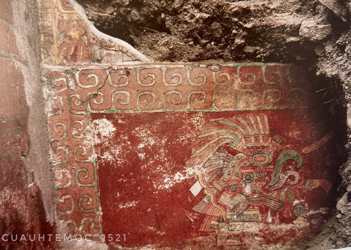
Hallazgo de un mural teotihuacano de más de 1600 años de antigüedad en el complejo habitacional de Techinantitla.
Se aprecia al Dios de las Tormentas sujetando el rayo y con la izquierda una mazorca de maíz. Está delimitado por un marco con volutas, que representan agua. Noten las vírgulas de la palabra frente a su rostro. Fotografía de el arqueólogo Saburo Sugiyama. #Teotihuacan
CHOLULA
(300 a.n.e. - 1521 d.n.e.)
En los límites de Puebla y Tlaxcala, entre los volcanes Popocatépetl e Iztaccíhuatl (en el poniente) y el volcán La Malinche (en el oriente), cerca del río Atoyac, descansa la antigua Ciudad Sagrada Tollan Cholollan Tlachihualtépetl, «Gran ciudad donde cae el agua en el lugar de huida del monte hecho a mano» [Tollan, «lugar de tules o juncos» o «ciudad o metrópoli»; Cholollan, «lugar de los que huyeron», «lugar del vado» o «lugar donde corre el agua»; y Tlachihualtépetl, «el monte hecho a mano»].
Hernán Cortés y Gonzalo Fernández de Oviedo la llamaron Churultecal, y Andrés de Tapia, Chitrula. Finalmente la descomposición del nombre terminó en Cholula.
Conoce la información completa aquí
👉 https://t.co/3NFhaAW1tp
Los primeros pobladores de Cholollan —pronúnciese Cholólan— llegaron alrededor del año 1000 a.n.e.
Cholula posee el basamento mesoamericano más grande, incluso mucho mayor que los basamentos de Teotihuacan: el Tlachihualtépetl, «el monte hecho a mano», dedicado a Chiconauhquiáuitl, «dios de las nueve lluvias», «concebida como un elemento central, un axis mundi que daba importancia a sus cuatro caras y a los espacios que las circundaban, pero denotando a la vez su estrecho vínculo con el Popocatépetl». Medía 400 metros por lado, 62 de altura y tenía un volumen de 4 500 000 metros cúbicos; sin embargo, no es el más alto del mundo.
Imágenes tomadas de mi libro Todos los caminos llevan a Tenochtitlan. En la imagen de la derecha se puede apreciar un comparativo de los basamentos más grandes de Mesoamérica.
En la parte superior izquierda de la figura se muestra el Tlachihualtépetl. En la superior derecha, el basamento del Sol en Teotihuacan. En la parte inferior de izquierda a derecha se observa el basamento de la Luna de Teotihuacan, el Gran Basamento de Cuicuilco, El Castillo de Chichén Itzá, el basamento del Adivino de Uxmal y el basamento de los Nichos en El Tajín.
¿Te gustaría saber quienes fundaron la ciudad de cholula?
Conoce la información completa en mi libro:
TODOS LOS CAMINOS LLEVAN A TENOCHTITLAN, tomo 2.
De venta exclusiva en Amazon.
Adquiere tu ejemplar aquí
👉https://t.co/3NFhaAW1tp
The three gold signet rings in the image come from the famous Tomb of the Griffin Warrior in Pylos. The tomb was discovered in 2015 near the Palace of Nestor and belonged to a Mycenaean warrior of high standing who lived around 1500–1450 BC.
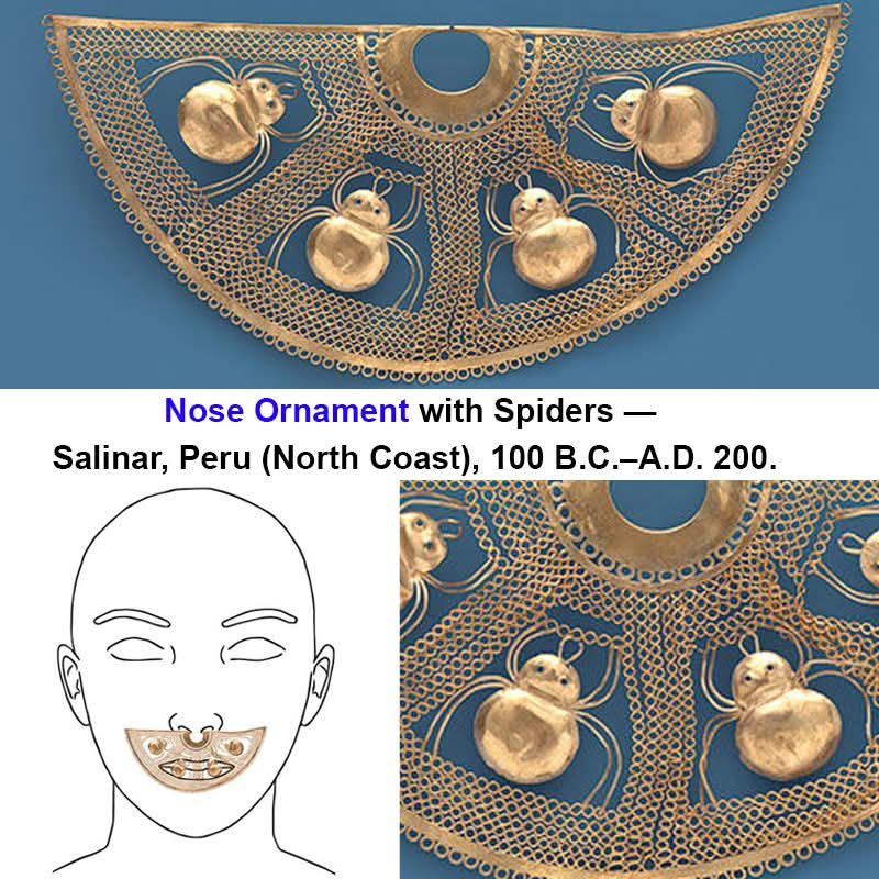
This elaborate gold piece is a Nose Ornament with Spiders from the Salinar culture of ancient northern Peru, dating approximately from 100 B.C. to A.D. 200.
The ancient storm god who ruled the skies
If you love ancient mythology you absolutely need to see this incredible stone carving.
This commanding figure is the mighty Storm God the absolute chief deity of the ancient Hittite Empire.
Known by many legendary names like Tarhu and Teshub he was fiercely worshipped by multiple different cultures living across ancient Anatolia.
Carved perfectly holding his powerful divine weapons he was deeply believed to control the wild weather and beautifully represented the ultimate unifying force of the entire federal state.
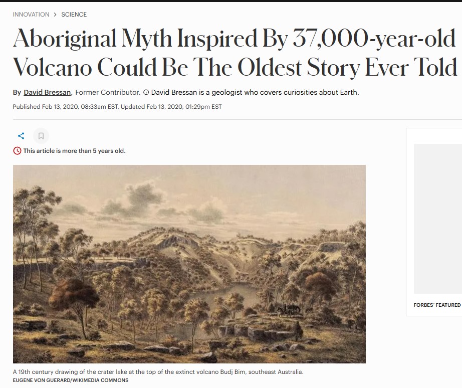
Australian Aboriginal oral histories preserve memories of post-glacial sea level rises from 13,000 years ago, and even of a volcanic eruption from 37,000 years ago!
Sadly, however, Homeric tradition could not have remembered anything from 400 years earlier and it's all entirely mythological 😢
Esto comparte con la arquitectura inca, según algunas de sus teorías se inspiraron en los granos de maíz (teselación hexagonal/orgánica por presión natural) o, tal vez en las escamas del cocodrilo (mosaicos poligonales flexibles y resistentes). https://t.co/GG8xY0GNZT
Los autores Garfinkel y Krulwich (2025) argumentan que la simetría extrema y la división precisa del espacio circular reflejan necesidades agrícolas: dividir equitativamente tierras comunales, cosechas, raciones o recursos entre el poblado.















![SofiGuadarramaC's tweet photo. CHOLULA
(300 a.n.e. - 1521 d.n.e.)
En los límites de Puebla y Tlaxcala, entre los volcanes Popocatépetl e Iztaccíhuatl (en el poniente) y el volcán La Malinche (en el oriente), cerca del río Atoyac, descansa la antigua Ciudad Sagrada Tollan Cholollan Tlachihualtépetl, «Gran ciudad donde cae el agua en el lugar de huida del monte hecho a mano» [Tollan, «lugar de tules o juncos» o «ciudad o metrópoli»; Cholollan, «lugar de los que huyeron», «lugar del vado» o «lugar donde corre el agua»; y Tlachihualtépetl, «el monte hecho a mano»].
Hernán Cortés y Gonzalo Fernández de Oviedo la llamaron Churultecal, y Andrés de Tapia, Chitrula. Finalmente la descomposición del nombre terminó en Cholula.
Conoce la información completa aquí
👉 https://t.co/3NFhaAW1tp
Los primeros pobladores de Cholollan —pronúnciese Cholólan— llegaron alrededor del año 1000 a.n.e.
Cholula posee el basamento mesoamericano más grande, incluso mucho mayor que los basamentos de Teotihuacan: el Tlachihualtépetl, «el monte hecho a mano», dedicado a Chiconauhquiáuitl, «dios de las nueve lluvias», «concebida como un elemento central, un axis mundi que daba importancia a sus cuatro caras y a los espacios que las circundaban, pero denotando a la vez su estrecho vínculo con el Popocatépetl». Medía 400 metros por lado, 62 de altura y tenía un volumen de 4 500 000 metros cúbicos; sin embargo, no es el más alto del mundo.
Imágenes tomadas de mi libro Todos los caminos llevan a Tenochtitlan. En la imagen de la derecha se puede apreciar un comparativo de los basamentos más grandes de Mesoamérica.
En la parte superior izquierda de la figura se muestra el Tlachihualtépetl. En la superior derecha, el basamento del Sol en Teotihuacan. En la parte inferior de izquierda a derecha se observa el basamento de la Luna de Teotihuacan, el Gran Basamento de Cuicuilco, El Castillo de Chichén Itzá, el basamento del Adivino de Uxmal y el basamento de los Nichos en El Tajín.
¿Te gustaría saber quienes fundaron la ciudad de cholula?
Conoce la información completa en mi libro:
TODOS LOS CAMINOS LLEVAN A TENOCHTITLAN, tomo 2.
De venta exclusiva en Amazon.
Adquiere tu ejemplar aquí
👉https://t.co/3NFhaAW1tp](https://pbs.twimg.com/media/HDAx83jbQAAOSuc.jpg)