Datumate is a Contech company that offers a cloud-based 4D data analytics and management platform for digitizing infrastructure construction projects. #contech
Choosing drones for survey-grade work isn't the same as choosing for inspection.
Sensor type, GSD, flight time, RTK — pick wrong and accuracy quietly tanks until QA. Our hardware guide: https://t.co/5Ga6azFEw7
Most drone mapping quotes leave out the costs that wreck budgets: data processing, mobilization, GCP surveys, re-flights, deliverable revisions.
The 7 line items most contractors don't see coming: https://t.co/t4YikKWQ9M
Manual surveys take days. Drone mapping does the same job in hours, at accuracy that meets or beats traditional methods.
Which part of your survey workflow eats the most time? https://t.co/AXLcPZ4fud
Most drone mapping quotes leave out 7 costs that can blow your budget wide open.
Data processing. Mobilization fees. GCP surveys. Re-flights. Rework. Storage fees. Expedited delivery.
Know what to ask before you sign. https://t.co/vI2np1RuO0
Managing one drone mapping vendor is straightforward. Managing five across active construction sites? That's a different challenge entirely. We put together a full guide 👇
https://t.co/KePZPr2Xf7
#DroneMapping#ConstructionTech#InfrastructureProjects
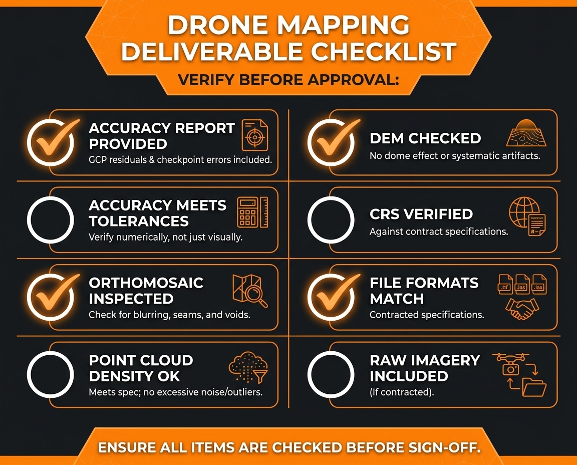
Your drone data looks great. But is it actually accurate? 🤔
Don't sign off until every box is ticked 👇
https://t.co/0oxPubiN4W
#DroneMapping#ConTech#Construction
Drone mapping vendor or in-house program? It's not just a cost question.
✅ Vendor: sporadic flights, specialized sensors, no compliance burden
✅ In-house: high frequency, on-demand flexibility, data control
✅ Hybrid: the best of both
https://t.co/bv5GcUey8o
Not all drones are created equal — especially when survey-grade accuracy is on the line.
We put together a full breakdown to help construction teams work through the decision. Read it here: https://t.co/8D8f4IYe1T
#DroneMapping#HeavyCivil#ConstructionTechnology#UAV
Every week without accurate site data is a week of decisions made on assumptions.
DatuBIM answers those questions without waiting on a survey to fly the site.
See it in action → https://t.co/8M7oJzYmlb
#HeavyCivil#DroneMapping#ConstructionTech#DatuBIM#Infrastructure
A monthly site walk doesn't cut it when you're building a bridge.
Our new blog breaks down how drone mapping fits into bridge and culvert construction workflows — from foundation prep through final as-built.
https://t.co/fS7yngxl4j
#DroneMapping#BridgeInspection
Drone data that never makes it into your BIM model is just expensive photography.
The integration step is where the real value gets unlocked — and it's more straightforward than most teams think. https://t.co/arKYYta3GJ
#DroneMapping#Infrastructure#AEC
Women in Construction Week is a powerful reminder that innovation on the jobsite is driven by diverse perspectives. How is your team supporting and elevating women in the field and office this week?
What if your construction site could measure itself? 🛸
Transportation agencies, general contractors, and survey firms are already transforming how they deliver infrastructure. The question is — are you? 💡
📩 Connect with our team to see a live demo: https://t.co/Mos81Lr1em