❄️ Let's Go Snow!
Chance of first flakes late Monday in DC area, especially west and north of Beltway.
Accumulation a good bet in mountains of eastern West Virginia, western Md, southwest Pa (Sun-Tue).
This is still 5 days away... so forecast will need to be refined.
Not happy trends (unless you hate snow…and I know some people do! 😂) from the latest Euro Ensemble either.
Last 6 runs shown here. For DC, the EPS mean has gone from 8” to 3” in the last 36 hours.
Still time for it to fight back a bit, but your odds for it to shift in such a way that would bring a blizzard threat back are naturally getting less likely the closer in we get, as upper air energy is being better sampled and interpreted by the computer simulations.
My Winter Forecast airs tonight. Find out about how much #SNOW Im expecting. I'll see you at 4,5&6, then again. For the NBC4 Rundown at 730!! What are you hoping to hear??
The next chance for measurable snow (at least 0.1") is Feb 24. Right now, Alexandria has an SLR of about 8:1 which means a low amount of snow. Watching. Could change.
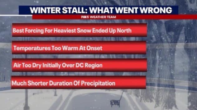
Here is a loop of the entire event. Mild temps and dry air played a role, sure...but with the dew point depression this easily could have been overcome had precipitation lasted longer. It was the shorter than expected duration of the event (over by 3am!) that hurt our totals.
A few reasons for why snow totals did not perform to expectation with model guidance.
Warm temperatures, dry air and a slight shift in the storm track. @7NewsDC
If you’re wondering why we did not get all the snow that was forecast here’s a look at why. While we did get snow, it was just not as much as we anticipated. In fact, a lot less. Mother Nature had other plans & all the factors shown below explain it all @fox5dc