@BowTiedBroke@jonathanbrozek Go back to school. Study physics along with atmospheric pressure and dew points, in correlation with increased passenger aircraft. I give up. I really do.
@BollocksWeather@NovaxForcazi No simple education these days. Chemtrails are vapour trails. Harmless, but yes they do condense under certain atmospheric conditions. Mainly pooly educated USA people getting sucked in. Physics, aeronautical and chemistry advised. Give me hope. Please stop spreading bullshit.
£100 FREE BET GIVEAWAY🤩
I’ve teamed up with @Fairplayapp and we are giving 4 people £25 in free bets🔥
To enter:
- Like this post
- Follow @Fairplayapp@theracehorseguy
- Retweet this post
Good luck, winner announced at 10am Wednesday 🤞🏽
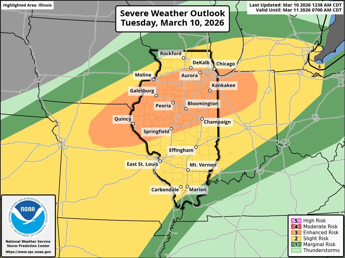
A significant threat for strong, long-track tornadoes exists across Illinois today as the @NWSSPC has issued two areas of Enhanced Risk. Unfortunately, the trend has not been your friend if you live in Illinois—especially near the I-80 corridor. A lifting warm front, with dew points over 65°F and extreme instability (CAPE values near 3500), will set the stage for a triple-point setup. Any storm that manages to initiate this afternoon could quickly become severe, posing a threat for significant tornadoes and destructive hail.
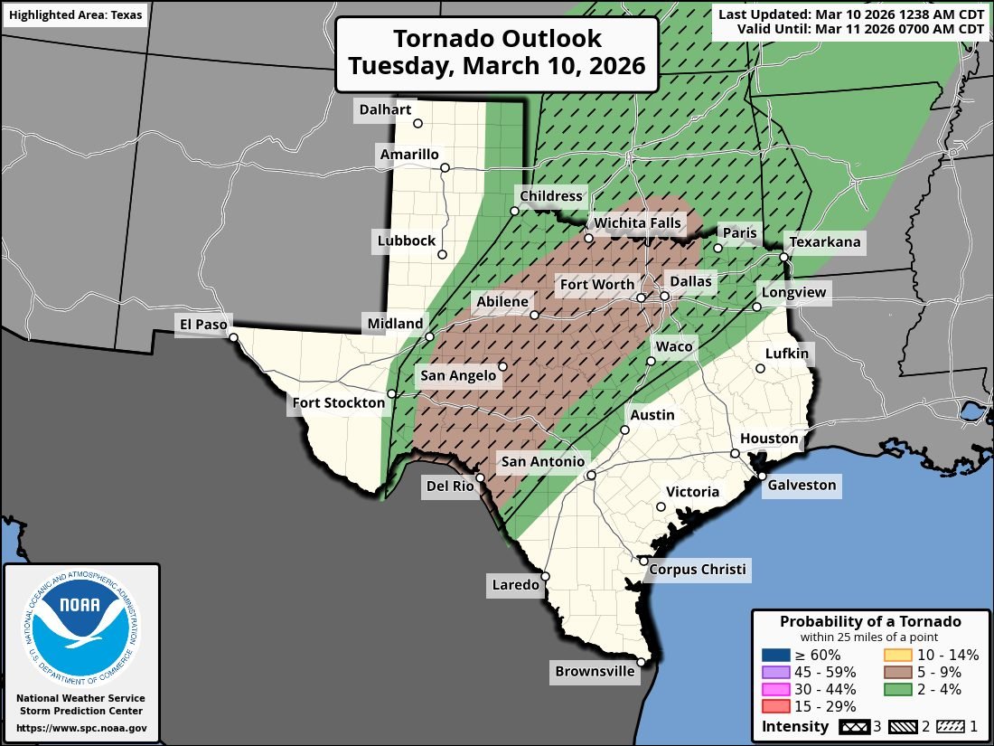
Further south in Texas, another Enhanced Risk is in place with a 5% hatched tornado area. The tornado threat there will likely be more QLCS-driven, though there will be a window for isolated tornadoes—possibly strong—as well. A significant hail and damaging wind threat is also expected, particularly in areas from Fort Worth and surrounding North Texas through the overnight hours.
Today is one of those days where you need to have a shelter or safety plan in place if you live in these areas. I will be covering this even live on the @MyRadarWX App.
#Ilwx #txwx #tornado
💰FREE BET GIVEAWAY! 💰
We’re giving away 5x £20 Free Bets to use on Cheltenham Day 1!
To Enter:
1. Like
2. Retweet
3. Follow @Fairplayapp
The winners will be announced 9AM tomorrow 🤝
18+ BeGambleAware
A DEADLY Tropical Cyclone has devastated the coastal areas of Madagascar on Wednesday. Homes and communities have been devastated, and thousands of people have been displaced.
GOLD CUP TICKETS GIVEAWAY🏆
@Fairplayapp are giving you and one friend a chance to win 2x gold cup tickets for this years Cheltenham festival 🤩
To enter:
- Like this post
- Follow @Fairplayapp
- Retweet this post
Good luck🤞🏽
How long is a day on each planet?
Jupiter spins at 28,000 mph. That is fast enough to circle the entire Earth in under an hour.
On Venus, the planet moves so slowly that you would celebrate a birthday before it finishes a single rotation.
TALK ABOUT A SNOWY MESS
The Northeast hasn't caught a break with all this snowfall.
To add to everything, unplowed roads likely made driving slicker and a little more difficult. If there is any positive, it's that there wasn't anyone else on the road. #MAwx
Hell Lane, also known as Shute’s Lane, at Symondsbury in Dorset is one of the deepest and best-preserved holloways in Britain, with its sandstone walls cut down to nearly 9 metres below the surrounding fields in places.
The word holloway comes from Old English and simply means a sunken road, formed where a route has been used so heavily for so long that it is gradually worn down into the ground.
The origins of this route almost certainly go back to prehistory. Tracks in this part of Dorset were already in use by the Bronze Age, and later by the Iron Age Durotriges, the Celtic tribe that occupied much of what is now Dorset, southern Somerset, Devon and parts of Wiltshire before the Roman conquest. As was common across Britain, newer roads and tracks followed the lines of older ones, so a prehistoric route could easily become a medieval and later highway.
Over centuries the surface was cut deeper by the passage of feet, hooves and cart wheels, combined with rainwater washing loose material away. This process would have accelerated in the Middle Ages, particularly after the building of Symondsbury church in the 14th century. The nearby name Quarry Hill points to where the building stone was taken from, and that stone would have been hauled along this very lane, grinding it ever further down into the bedrock.
Just a short distance away lies Bridport Harbour, now West Bay, which was a long-established port for fishing and trade. Goods from the coast would have been taken inland along routes like this, linking harbour, village and hinterland.
The walls of Hell Lane are covered in centuries of scratched names and symbols, a long-running tradition of marking the place that stretches from early travellers to modern visitors. The graffiti forms a kind of informal record of the many people who have passed through this narrow cutting.
Dorset’s coastline was also a centre of smuggling in the 17th and 18th centuries, and figures such as Isaac Gulliver made their fortunes running contraband from secluded beaches to inland markets. Sunken lanes like Hell Lane, hidden from view and difficult to patrol, were ideal for moving goods such as gin, tea, silk and lace away from the coast without attracting attention.
Today the lane feels almost like a trench cut through time, preserving thousands of years of movement, trade and daily life in its walls and floor.