In Temblor's latest, @phivolcs_dost scientists explore recent earthquake swarms off the shores of the southern Philippine island of Mindanao, and compare what's happening to the devastating 1976 Moro Gulf earthquake.
https://t.co/sbSW2sKutm
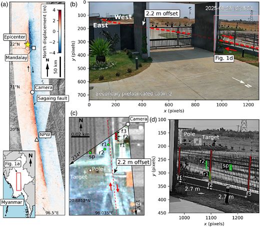
🌟OPEN ACCESS🌟 Coseismic Displacement Characteristics near the Epicenter of the Mw 7.7 Myanmar Earthquake on 28 March 2025: Insights from Beijing‐3 High‐Resolution Satellite Imagery Analysis #SRL
https://t.co/r7l5Gj93Dq
🌟OPEN ACCESS🌟 Earthquake Rupture Arrest from Depth‐Dependent Frictional Stability on the Pütürge Segment of the East Anatolian Fault Zone, Türkiye (Turkey) #TSR
What causes an earthquake rupture to cease propagation?
https://t.co/JthE6abut3
Tomita, F. Re-evaluation of the interseismic slip deficit rates along the Kamchatka subduction zone. Earth Planets Space 78, 41 (2026). https://t.co/Qtw7tndFiI
Ayon sa bagong pag-aaral ni Deo Carlo Llamas, isang geologist sa Philippine Institute of Volcanology and Seismology (PHIVOLCS) at Mario Aurelio, isang propesor sa University of the Philippines Diliman - College of Science - National Institute of Geological Sciences (UPD-CS NIGS), na ilang residente sa bayan ng Dimasalang, Palanas, at Cataingan sa Masbate Island ang nakatira malapit sa fault line.
Tumama ang magnitude 6.2 na lindol sa Masbate Island noong Pebrero 15, 2003.
At 17 taon matapos ang insidente, ito ay sinundan ng isang magnitude 6.6 na lindol sa parehong fault sa isla noong Agosto 18, 2020 na nagdulot ng surface rupture, landslides, at local tsunami ang parehong lindol.
“This observation — that the rupture occurred at the same location as before — underscores the critical importance of active fault mapping for assessing ground rupture hazards,” saad pa ng mga experts.
#PilipinasToday
#Masbate
#Lindol
🔍 New Article Published in GeoHazards!
📖 Seasonal and Episodic Variation of Aseismic Creep Displacement Along the West Valley Fault, Philippines
✍️ by Rolly E. Rimando, Deo Carlo E. Llamas, Bryan J. Marfito and Renato J. Garduque
Read more: https://t.co/vpybC7K1QR
Surface Rupture from an Aftershock: Remote Observations from the January 2024 Wushi (Aykol), China, Earthquakes #SRL
An aftershock appears to have produced surface rupture, whereas its mainshock did not.
https://t.co/xKN0YnRAtL
🌟OPEN ACCESS🌟Curved Fault Slip Captured by CCTV Video During the 2025 Mw 7.7 Myanmar Earthquake🔥PRESS RELEASE🔥#TSR
Dramatic video of fault slip during the recent Myanmar earthquake thrilled observers, but what data did it hold?
Video: https://t.co/bXBJryLyDC
@WinterFell1701 Looking back at this tweet, there really was a video that captured a fault rupture (just a little less than a year after this was posted) and it happened during the 2025 Myanmar earthquake.
https://t.co/bDjcyMTmF2
Likely surface rupture of the 2025 M7.7 Myanmar earthquake caught on cam! The shift of the ground to the right is so striking!
Source: https://t.co/Os0AOVt1eP
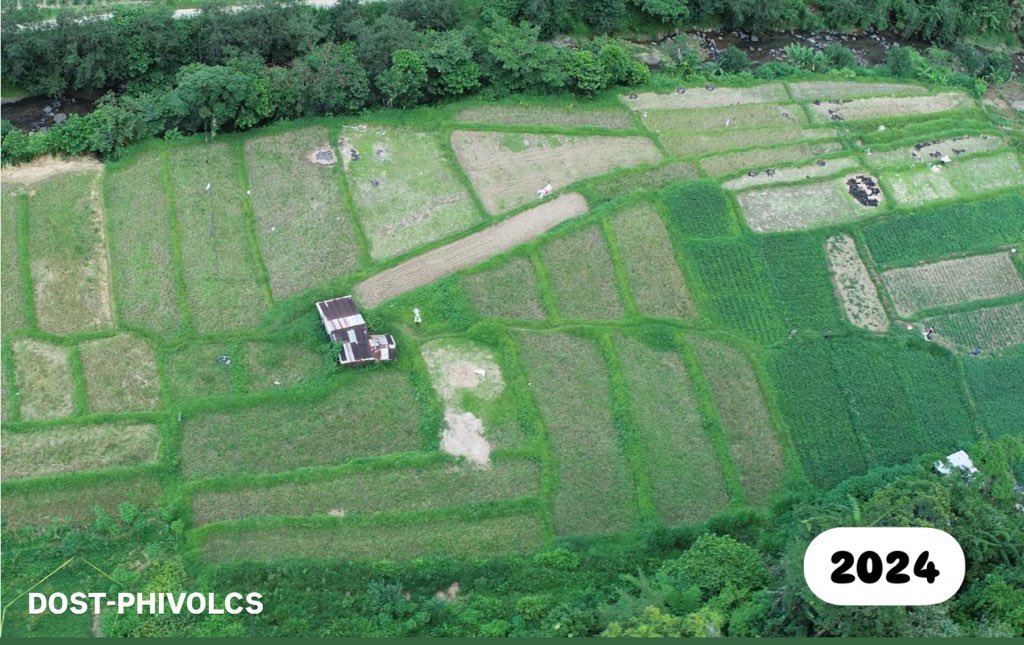
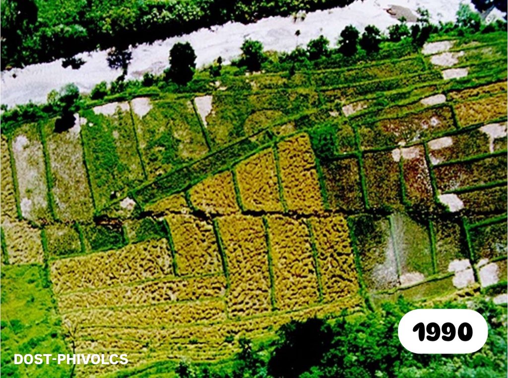
#OnThisDay in 1990, the Digdig segment of the Philippine Fault generated a M7.8 earthquake in Luzon, producing a ~125 km surface rupture with ~6m maximum left-lateral offset.
Thirty-four years later, we revisited a section of the rupture and found the fault offsets still visible
#OnThisDay in 1990, the Digdig segment of the Philippine Fault generated a M7.8 earthquake in Luzon, producing a ~125 km surface rupture with ~6m maximum left-lateral offset.
Thirty-four years later, we revisited a section of the rupture and found the fault offsets still visible
Likely surface rupture of the 2025 M7.7 Myanmar earthquake caught on cam! The shift of the ground to the right is so striking!
Source: https://t.co/Os0AOVt1eP
Updated Optical image correlation using Sentinel-2 data
N-S displacements along the Sagaing Fault suggest a surface rupture of approximately 500 km — unusually long fault rupture for a magnitude 7.7 earthquake!
The maximum ground offset reaches more than 4 m.
-DETect Faults
Apocalyptic scenes from Mandalay, MM. Only seeing small snippets of what is happening, given minimal internet or electricity. Supplies of food and water running scarce. Lack of machinery or govt support to find people under buildings.
#WhatsHappeningInMyanmar#MyanmarEarthquake
Updated Optical image correlation using Sentinel-2 data
N-S displacements along the Sagaing Fault suggest a surface rupture of approximately 500 km — unusually long fault rupture for a magnitude 7.7 earthquake!
The maximum ground offset reaches more than 4 m.
-DETect Faults
Sentinel-2 Optical correlation using MicMac software (03272025 - 03302025).
N-S displacements along the Sagaing Fault suggest a surface rupture of exceeding 300 km!
-DETect Faults team
Updated Optical image correlation using Sentinel-2 data
N-S displacements along the Sagaing Fault suggest a surface rupture of approximately 500 km — unusually long fault rupture for a magnitude 7.7 earthquake!
The maximum ground offset reaches more than 4 m.
-DETect Faults