6/ Mein vorläufiges Resumée: Migration bleibt eines der drängendsten politischen Themen Europas. Aber ein Ansturm auf die afrikanische Exklave Ceuta ist noch lange keine Wiederholung der Flüchtlingskrise von 2015/16 – so dramatisch die Bilder auch wirken.
🔥 Les Canadair écopent actuellement sur le lac de Sainte-Croix afin de lutter contre l'incendie de Correns, dans le Var
✈️ Pas moins de 6 Canadair sont engagés sur cette intervention : 5 de la Sécurité civile française et 1 CL-415 croate, déployé dans le cadre du mécanisme européen de protection civile
💧 Le lac de Sainte-Croix permet aux équipages d'effectuer des écopages rapides afin d'enchaîner les largages sur le front de flammes
⚠️ La situation reste évolutive. Évitez le secteur et laissez les secours intervenir dans les meilleures conditions
__
📸 Patrick Hauc
🚫Évitez le secteur
🚒Facilitez l'accès aux secours
#incendie #FeuxDeForêt
🔥 Wildfires across Portugal 🇵🇹 and W Spain 🇪🇸 scorched forests and disrupted communities in late July.
🛰️ #CopernicusEU Sentinel-2 imagery maps active fires and burn scars, helping authorities assess impacts and coordinate response.
🔗 https://t.co/26XLCoGfkm
#ImageOfTheDay
Nochmal die Fakten für Deppen wie @aus_pete et al:
1. Glasscherben können kein Feuer machen.
2. Weggeworfene Zigaretten sind Brandstiftung.
3. Der Klimawandel macht kein Feuer, aber durch die mit ihm verbundenen Dürreperioden steigt der Erfolg von Brandstiftungen dramatisch.
4. Feuer entstehen durch Brandstiftung oder Blitze am Rande von Gewittern (Letzteres bei uns sehr selten, in borealen Wäldern häufiger). Sonst gibt es außer Paulanergschichtln mit brennenden Vögeln und mehr keine bekannten Möglichkeiten, einen Waldbrand zu machen. Es braucht dafür 250 bis 300 Grad. Solange das Brennmaterial trocken genug ist, ist die Lufttemperatur schietegal.
5. Wenn das Feuer einmal da ist, hat die Windgeschwindigkeit einen großen und die Lufttemperatur einen geringeren Einfluss auf die Aggressivität des Feuers.
Es ist ja gut und richtig, dass halb Europa Spanien daran erinnert, seinen Verpflichtungen zur Grenzsicherung nachzukommen.
Was mir aber fehlt, sind ein paar Worte zu Marokko, die diese Welle durchgelassen (und vielleicht auch orchestriert) haben.
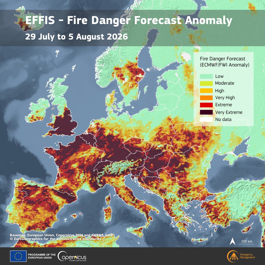
The latest #EFFIS Fire Danger Forecast Anomaly for 29 July-5 August highlights unusual conditions across Europe
Darker areas = stronger anomalies vs. historical data, meaning weather conditions are expected to be more favourable than usual for wildfire spread in case of ignition
🔥 Weekly wildfire situation in Europe
Since the beginning of the year:
📍1,407 fires
🌍434,976 ha burnt
🌫️17.98 Mt CO₂ emitted
Fire danger forecast for the next 7 days ⬇️
We are monitoring closely and stand ready to assist.
#EUCivilProtection
More: https://t.co/blKGf6swVu
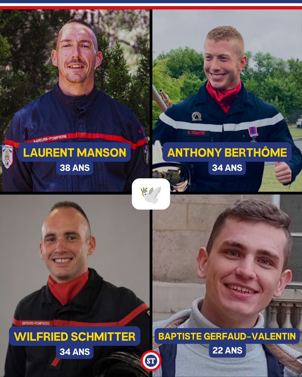
🇫🇷 Laurent, Anthony, Wilfried, Baptiste, ces 4 pompiers nous ont quittés en luttant contre les incendies en France 🕊️
Laurent Manson, 38 ans
Anthony Berthôme, 34 ans
Wilfried Schmitter, 34 ans
Baptiste Gerfaud-Valentin, 22 ans
Pensées pour les familles, les proches et toutes les personnes qui luttent contre ce fléau ❤️
🔥 A wildfire near la Vall d'Uixó 🇪🇸 burned over 7,200 hectares by 27 July.
🛰️ This #CopernicusEU Sentinel-2 comparison shows the fire in natural and false colour, revealing smoke, active fire fronts and the burn scar.
🔗 https://t.co/a2ouSbe0Iv
#ImageOfTheDay
@Bjoern__M Der vorhandene Rechstrahmen unter dem wesentliche Teile des OPLAN abliafen ist hakt problematisch. Außwr halb des äuseren Notstands gelten 16 verschiedene Gefahrenabwehrgesetzgebungen. Eine Änderung wäre alleine schon zur Vereinfachung wünschenswert
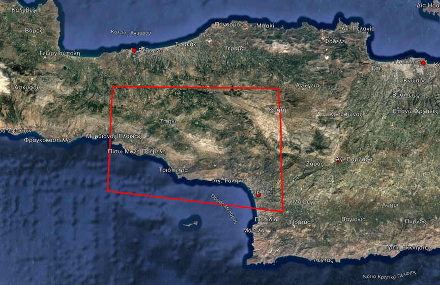
🛰️Ενεργοποίηση της Υπηρεσίας #Copernicus EMS🇪🇺 για άμεση χαρτογράφηση περιοχών του Δήμου Αγίου Βασιλείου #Ρέθυμνο που επλήγησαν από δασικές 🔥
🛰️Activation of @CopernicusEMS 🇪🇺 for the immediate mapping of the areas in #Rethymno affected by a #forestfire
🔗https://t.co/Oi96fZ01sy
📢Discover the new #EUSpace website in this Observer article
Designed as a central entry point for information about the EU Space Programme, it showcases key thematic areas and real-world applications, including the capabilities of #CEMS
More at 👇 https://t.co/vYmii6HwXj
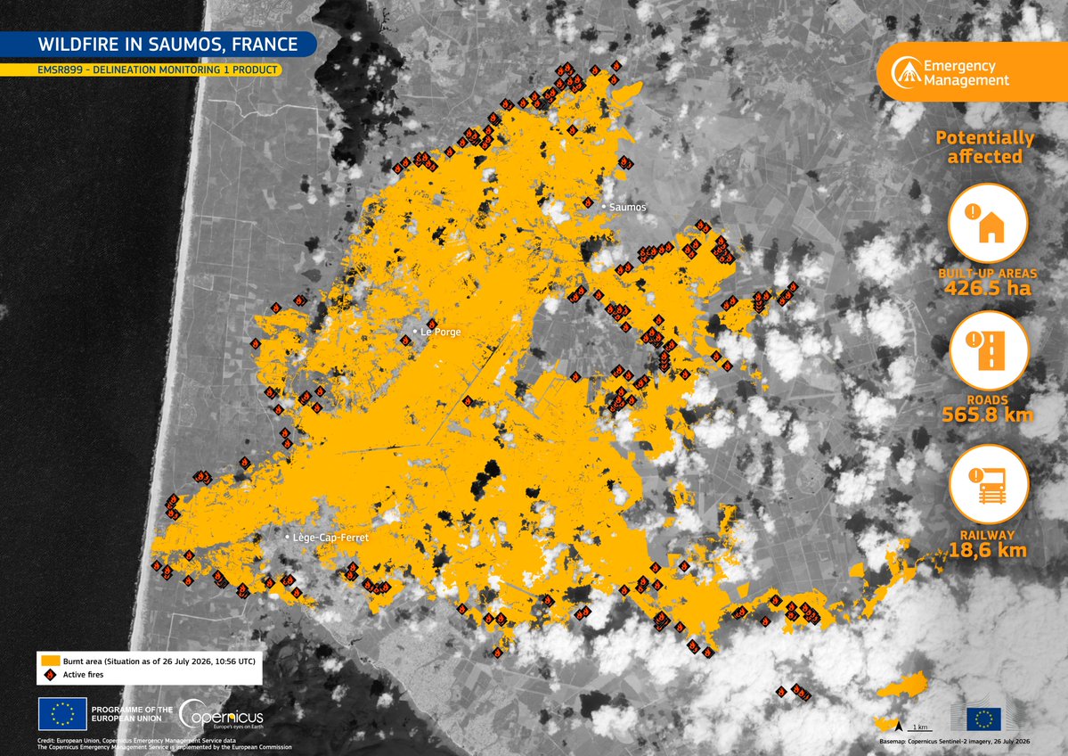
🔥 Wildfires near Saumos and Biscarrosse 🇫🇷 have burned tens of thousands of hectares, prompting the evacuation of around 220K people.
🛰️ #CopernicusEU CEMS Rapid Mapping supports authorities by tracking active fire fronts.
🔗 https://t.co/JxT8yseRRy
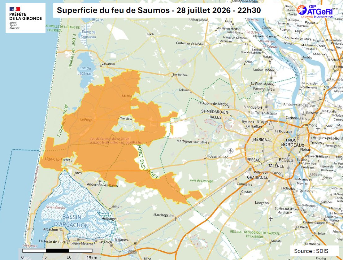
⚠️ Incendie en cours en #Gironde | Point de situation du mardi 28 juillet à 22h30.
La journée a été marquée par 14 reprises de feu. Toutes ont été traitées par l’action des sapeurs-pompiers sur le terrain et par l’appui des moyens aériens.
▫️ 121 kms de coupes tactiques réalisés
▫️ Le feu est stabilisé mais demeure actif
En savoir plus sur https://t.co/SByG9A8ysp
@Interieur_Gouv | @SecCivileFrance | @Gendarmerie_033 | @PoliceNat33 | @ArmeesNoA | @DFCIaquitaine
L'émotion est immense face à tous vos messages et à votre soutien. 🔥 Chaque témoignage reçu nous touche et nous encourage à poursuivre notre engagement à vos côtés.
Alors, tout simplement...
Merci.
Ayer a nuestra llegada #IfBurgohondo , maniobra de Estacionamiento,llegamos dnd no llega nadie , Pilotos y Bomberos Forestales #BRIF , entrenamos y nos preparamos para lo extremo ,mostramos nuestro trabajo xq nos enorgullece lo que hacemos. @Rotorsun@mitecogob seguimos 🚁🧑🚒