கடந்த 2026 ஆம் ஆண்டு, ஏப்ரல் மாதம், CBSE அமைப்பு, மாணவர்களுக்கு ஆறாம் வகுப்பிலிருந்து மூன்று மொழிகள் கட்டாயம் என்றும், அந்த மூன்று மொழிகளில் இரண்டு மொழிகள் இந்திய மொழிகளாக இருக்க வேண்டும் என்றும் அறிவித்தபோது, இந்தியாவின் பலதரப்பட்ட இலக்கிய மற்றும் கலாச்சார பாரம்பரியத்தை, சிறுவயதிலேயே குழந்தைகள் அறிந்து கொள்ள உதவும் என்பதால், அந்த முடிவை வரவேற்றவர்களில் நானும் ஒருவன்.
குறிப்பிட்ட 2026 ஆம் ஆண்டு ஏப்ரல் மாதம் வெளியிடப்பட்ட அறிவிப்பில், ஒன்பதாம் வகுப்பு CBSE மாணவர்களுக்கு மூன்றாவது மொழியை கட்டாயமாக்குவது, இன்றிலிருந்து மூன்று ஆண்டுகளுக்குப் பிறகு, 2029-30 கல்வியாண்டிலிருந்து மட்டுமே அமல்படுத்தப்படும் என்று தெளிவாக குறிப்பிடப்பட்டிருந்தது.
ஆனால், கடந்த வாரம், மே 15, 2026 அன்று, CBSE அனைத்து இணைப்பு பள்ளிகளுக்கும் அனுப்பியுள்ள புதிய சுற்றறிக்கையில், இந்தக் கல்வியாண்டிலிருந்தே ஒன்பதாம் வகுப்பு மாணவர்களுக்கு மூன்றாவது மொழியை கட்டாயமாக்கியுள்ளது. இதன் மூலம், 2029-30 கல்வியாண்டிலிருந்து மட்டுமே அமல்படுத்தப்படும் என்ற தனது முந்தைய அறிவிப்பை, CBSE அமைப்பு மீறியிருக்கிறது.
CBSE அமைப்பின் இந்த திடீர் அறிவிப்பு, பெற்றோர்களுக்கு, குறிப்பாகத் தமிழக மாணவர்களின் பெற்றோர்களுக்குப் பெரும் அதிர்ச்சியை ஏற்படுத்தியிருக்கிறது. ஏனெனில், அவர்களின் குழந்தைகள் ஏற்கனவே ஆறாம் வகுப்பிலேயே தாங்கள் விரும்பிய மொழியைத் தேர்வு செய்துள்ள நிலையில், தற்போது வெளியிடப்பட்டுள்ள புதிய அறிவிப்பின் படி, ஒன்பதாம் வகுப்பு மாணவர்கள் மூன்று மொழிகளை கட்டாயமாகக் கற்க வேண்டும் என்றும், அதில் இரண்டு மொழிகள் இந்திய மொழிகளாக இருக்க வேண்டும் என்றும், அது இந்தக் கல்வியாண்டு 2026 ஜூலை 1 முதலே அமலுக்கு வரும் என்றும் கூறப்பட்டுள்ளது.
மிகவும் குறுகிய காலத்திற்குள் ஒன்பதாம் வகுப்பு மாணவர்கள் மற்றுமொரு புதிய மொழியைக் கற்க வேண்டும் என்று எதிர்பார்ப்பது, குழந்தைகளுக்கு தேவையற்ற மனஅழுத்தத்தை ஏற்படுத்தி, அவர்களின் மொத்தக் கல்வித் திறனையும் பாதிக்கும்.
எனவே, இந்த புதிய அறிவிப்பை மத்திய கல்வி அமைச்சகம் உடனடியாக திரும்பப் பெற வேண்டும் என்றும், ஒன்பதாம் வகுப்பில் மூன்று மொழிகள், அதில் இரண்டு இந்திய மொழிகள் கட்டாயமாக்கப்படும் திட்டத்தை, முன்பே அறிவித்தபடி மூன்று ஆண்டுகளுக்குப் பிறகு, 2029-30 கல்வியாண்டிலிருந்து மட்டுமே அமல்படுத்த வேண்டும் என்றும் கேட்டுக்கொள்கிறேன்.
CBSE answer sheet fiasco is a reminder to many - don’t rush to label every complaint as fake, AI-generated noise, bots, or politics.
Not every outrage is manufactured. Some grievances are real, documented, and carry consequences that can shape someone’s future.
A little patience and fact-checking before dismissal can go a long way.
Hello dear students of #CBSE . Any one of you struggling with your evaluation of marks , wanting to go for re evaluation. If post getting your PDFs there is some very fundamental error that you have come across, then reach out to us. We are planning a full show around the worst discrepancies in marking. U can DM me here. We are with you
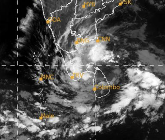
First major system of 2026 on cards and surprisingly it is for #Tamilnadu which is a rarity this time of the year!!
LPA has already formed over SE BOB & has now further intensified into a WML over the same region. Chances of it to intensify further looks pretty decent & rains are going to enhanced significantly as it will interact with western disturbance. Bad news for Delta as it is harvest season!! Let’s hope this doesn’t end up being disastrous.
Rains chance for Chennai city looks pretty decent as well. Few more days and we can have a better clarity as always.
#Chennairains #Tamilnadu #heavyrains
Delta to Cuddalore in hotspot. KTCC (Chennai & Surrounding districts) too in the path of heavy rains. Entire North Tamil Nadu is looking good.
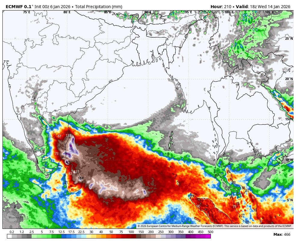
Srilanka will see heavy rains in east coast and adjoining areas from
Batticola, Trincomalee to Jaffna will see very heavy rains. This wont be like Ditwah, still there will be very heavy rains on 9 and 10th January. Jaffna belt alone should be prepared for extreme rains.
Rains will start in Delta on 9th while Chennai (KTCC) will see heavy rains on 10/11th January.
Read the detailed post - https://t.co/eT6k1pZlrx
The upcoming low pressure system may bring rainfall to Puduchery to south Tamilnadu region on Jan 8/9/10
#Chennai, let us wait for nowcast to see any spill over spells(lite)
Calm and cold weather over #Chennai.
Easterly wave might bring showers to Puduchery,Delta,South Tamilnadu from Dec 16th to 17th.
#Chennai cloudy, and occasional morning showers are possible.
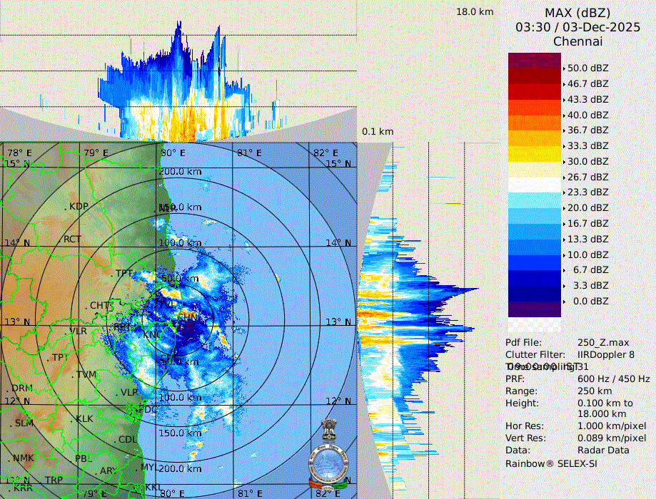
Intense clouds moving into part of Chennai City. Dont be surprised if we get heavy rains in KTCC (Chennai) today. Ithuku oru end card ah illya ? - Yes today will be the last day for KTCC for heavy rains from this Depression and chances of rains in KTCC will be there till night.
Ennore 500 mm Rainfall from Ditwah and will add tally one more day.
51 mm - 30.11.2025
49 mm - 01.12.2025
260 mm - 02.12.2025
144 mm - 03.12.2025
JFF: Leave vitta mazhai ninnudum sonna kootam enga ?
A Great Day Ahead for all districts of Tamil Nadu
-------------------------
Today, all districts of Tamil Nadu are set to get some rains as the moisture push from the moving low pressure spreads across the state. Bangalore too will get rains. West - Coimbatore, South - Nellai, East - Delta, Central - Salem/ Trichy everyone gets their share today There is no pinpointing a single district today; the entire state is in play. Rains will be there in some places and some places will miss in your district.
Sensing very good spells in KTCC (Chennai) for next 24 hours.
--------------------
Radar Turning good, Within minutes we can storms circling Chennai. This is what we say as long as circulation is there clouds can form just like that out of nowhere. It will be rains with breaks.
Down south delta districts are getting isolated rains from inflow bands.
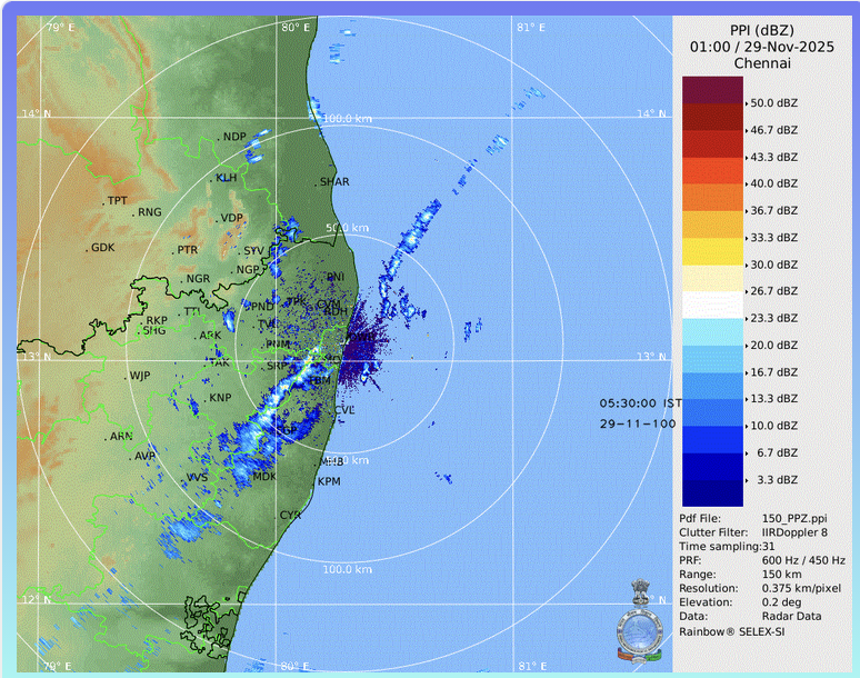
Depression is close to our coast and moving North and the outer rain band is over the #Chennai coast
Rain band extending from Sriharikota to South Chennai and moving toward the sea at the south
7 am update: Rain bands off the Delta coast are showing signs of weakening as # Cyclone Ditwah is lingering over the Northern tip of Srilanka.
Note: Scattered rain over #Chennai is from the feeder band (outflow) and not from the main rain band from #CycloneDitwah, and it will be a narrow line of storms moving towards the centre of the system.
Heads up: There is a high possibility of heavy to very heavy rainfall from Karaikal to Nellore (AP) due to #96B.
For #Chennai, heavy rainfall is possible from November 29th late evening/night to November 30th
We need to monitor the system in real time, especially the rain band formation, to gauge the rainfall quantum more precisely. As of now, my expectation for the Chennai region is around 7–10 cm (average — 70% probability).
Note:
The system’s track is not yet confirmed. We need to monitor its progress over the next 24 hours. Wind shear near the TN coast remains high (up to 30 knots), and dry air intrusion is also present—both of which could influence the system’s intensity and movement.
கவனக்குறிப்பு: #96B காரணமாக காரைக்கால் முதல் நெல்லூர் (ஆந்திரா) வரை உள்ள கடற்கரை மாவட்டங்களில் கன முதல் மிகக் க மழை பெறும் சாத்தியம் அதிகமாக உள்ளது.
சென்னைப் பகுதிக்கு, நவம்பர் 29 ஆம் தேதி மாலை/இரவு முதல் நவம்பர் 30 ஆம் தேதி வரை கன மழை பெய்ய வாய்ப்பு உள்ளது.
மழை அளவைச் சரியாக மதிப்பிட, சிஸ்டத்தை நேரடியாக கண்காணித்து, குறிப்பாக மழைப்பட்டை (rain band) உருவாக்கம் எப்படி முன்னேறுகிறது என்பதைப் பார்க்க வேண்டும். தற்போதைய நிலையில், சென்னைப் பகுதியில் சுமார் 7–10 செ.மீ. (சராசரி — 70% சாத்தியம்) மழை கிடைக்கும் என நான் எதிர்பார்க்கிறேன்.
குறிப்பு:
சிஸ்டத்தின் பாதை இன்னும் உறுதி செய்யப்படவில்லை. அடுத்த 24 மணி நேரத்தில் அது எப்படி நடக்கிறது என்பதை கவனிக்க வேண்டும். தமிழ்நாடு கரை அருகே காற்று முறிவு (wind shear) அதிகமாக (அதிகபட்சம் 30 நாட்டு) உள்ளது. அதோடு உலர் காற்றின் தாக்கமும் காணப்படுவதால், சிஸ்டத்தின் வலிமை மற்றும் நகர்வில் பாதிப்பை ஏற்படுத்தலாம்.
Chakkaram update - 27th November 2025, morning. Things looking good as of now.
-------------------
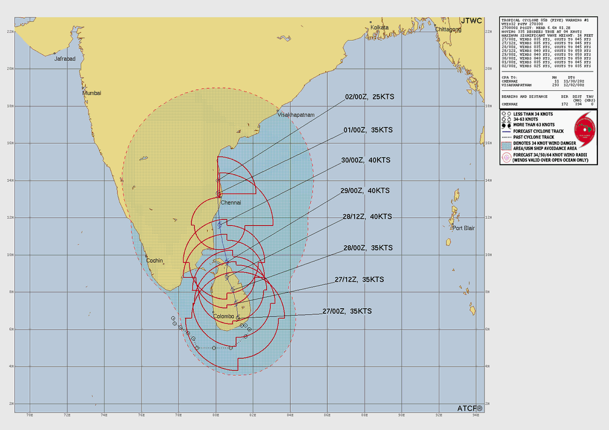
No changes in the forecast. The Chakkaram is expected to become a named cyclone and come very close to the coast between Chennai and Pondy region, whether it crosses the coast close to chennai or stays in open seas needs to be seen as there is no confirmation on the same. The rainfall impact will be as follows -
29th November
----------
Very heavy rainfall areas - Nagai, Tiruvarur, Mayiladuthurai, Cuddalore and Pondy
Heavy rainfall area - Thanjavur, Ramanathapuram, Pudukottai, Trichy, Salem, Namakkal, Ariyalur, Kallakuruchi.
29 into 30th November
--------------------
Very heavy rainfall areas - Chennai, Kancheepuram, Villupuram, Villupuram coast, Tiruvallur, Chengalpet
Heavy rainfall areas - Tiruvannamalai, Vellore, Villupuram interiors, Ranipet.
In case of delay, there will be slight changes in shift in rainfall. In case it crosses coast between Chennai and Pondy then Interiors like Dharmpuri, Krishnagiri, Tirupattur and Bangalore too will get rains.
Note: Please see the classification of Rainfall:- Category 24 hour rainfall over a station ending at 0830 hours
-----------------------
Very Light Rain: Trace – 2.4 mm
Light Rain: 2.5 – 15.5 mm (upto 2 cm)
Moderate Rain: 15.6 – 64.4 mm (2 to 6 cm)
Heavy Rain: 64.5 – 115.5 mm (7 to 12 cm)
Very Heavy Rain: 115.6 – 204.4 mm (12 to 20 cm)
Extremely Heavy Rain: ≥ 204.5 mm (> 20 cm)
As the circulations on either side of Sri Lanka get ready to consolidate and become on Low Pressure Area over SW Bay of Bengal the rains over South TN and delta districts may see reduction for the next 24 hours or so. The rains are expected to return gradually from tomorrow with initially South TN getting the rains and the rainfall impact gradually moving up as the circulation climbs up. While there is still some variance in terms of intensity of rainfall event over the respective areas marked in the map we have given an estimated timeline so that people who have events etc can be better prepared. There could be some delay in the timelines if the consolidation and associated movement of the circulation gets delayed. We may have better clarity on the intensity of the disturbance as well in the next 24 hours.
ECM remains consistent in projecting that the Comorin low will strengthen into a low-intensity system, possibly reaching depression (or deep depression) status, and then track along the Tamil Nadu coast towards the Andhra Pradesh coast. Along its path, the Tamil Nadu coastline — including #Chennai — is likely to receive rainfall as per the current forecast.
ECM suggests that the MJO will remain in Phase 6 and move to 7, with its amplitude briefly dipping below 1 before rising again. If the amplitude remains low, it could support better rainfall over the basin; otherwise, the intensity of the upcoming system may remain weakened.
ECM கணிப்பின் படி MJO 6/7-ஆம் நிலையில் தொடரும். அதன் அலைவீச்சு தற்காலிகமாக 1-க்கு கீழே குறைந்துவிட்டு பின்னர் மீண்டும் அதிகரிக்கும் வாய்ப்பு உள்ளது. அலைவீச்சு குறைந்த நிலையில் இருந்தால், வங்கக்கடல் பகுதியில் தீவிர மழை; இல்லை என்றால் வரவிருக்கும் அமைப்பின் தீவிரம் குறையலாம்.
red: days 1-7, blue: days 8-14, purple: >=day15