For #USMNT fans: I've done a complete and thorough rundown on every possible scenario for who the U.S. could play not only in the #FIFAWorldCup Round of 32, but even the Round of 16 and the quarterfinals.
Hurdle 1: Bosnia & Herzegovina vs. Qatar
More 👇 https://t.co/vVL2IVPJx6
Guys please don‘t follow any of these pages. I see my favorite football club is following it, and companies are in the comments and probably in the DM’s as well. It‘s not me!!!
Tullahoma Lanes is now part of the @STNWeather Skycam Network. If you’re in our area and not using the app, you should be! Get the BEST local weather here: https://t.co/jKhZEGeP5p
Monday: A Deeper Look into the Evolving Forecast
The forecast has shifted a bit… but that’s how this works
Higher-end threat trending NW, but NOT zero here
I break down what changed, why it changed, and what it means locally
Also a look at this weekend’s rain
Presented by Heritage South Community Credit Union!
https://t.co/34BoMANObu
🚨 BIG NEWS: CHRISTOPHER KING JOINS SOUTHERN TENNESSEE WEATHER 🚨
We’re proud to welcome Christopher King to the Southern Tennessee Weather team!
Christopher, founder of Christopher King WX, has become a trusted voice across Tullahoma, Franklin, and Moore counties with his clear, no-hype, community-first approach to weather coverage.
With nearly 20 years in education, he brings something unique—he doesn’t just tell you the forecast… he helps you understand the why behind it.
From storm spotter training with the National Weather Service and Skywarn to now continuing his education through Pennsylvania State University, Christopher is constantly working to better serve YOU.
He’s also a husband, dad, and neighbor right here in our community—which means he understands how important reliable weather information is when it matters most.
Christopher will help expand our coverage across Southern Middle Tennessee while continuing the mission of delivering clear, honest, and trustworthy weather information.
Elijah Kirby will remain the driving force behind STN Weather, but Christopher is going to be a HUGE asset to the communities we serve.
👉 Learn more: https://t.co/UbxaQaCeOO
After the win over Iowa State, a video circulated of Tennessee participating in the Lord’s Prayer.
How has Rick Barnes’ beliefs rubbed off on the team?
“I know specifically that one of the reasons I came to Tennessee was because of Rick Barnes and his faith” -Nate Ament
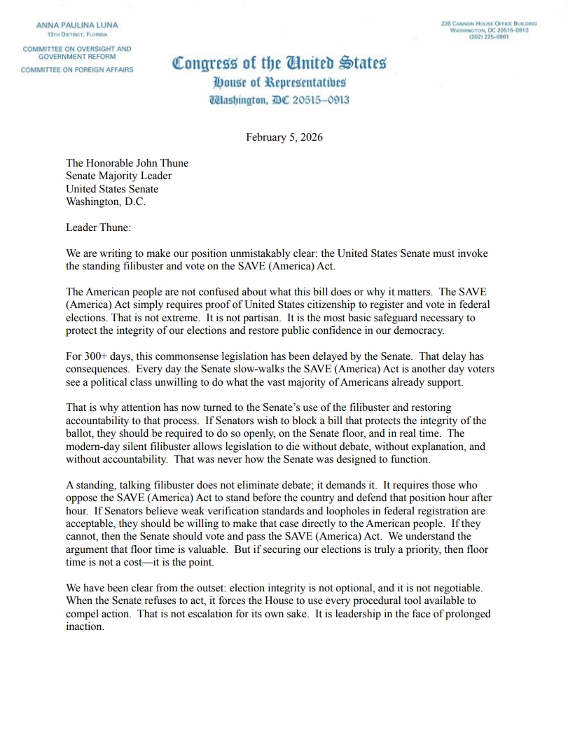
Alright folks, it’s time. @LeaderJohnThune MUST invoke the standing filibuster and bring the SAVE America Act to the floor of the US Senate.
Any Senator — Republican or Democrat — who opposes this commonsense election integrity bill will have to explain to the American people why they’re standing against 83% of the country.
Proud to team up with @realannapaulina to get this moving in the Senate.
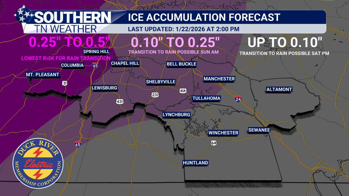
IN CASE YOU MISSED IT: Here’s a quick rundown on the latest forecast for this weekend.
An impactful winter storm is expected to impact Southern Middle Tennessee. A Winter Storm Warning is in effect for Bedford, Coffee, Grundy, Marshall, and Maury Counties. A Winter Weather Advisory is in effect for Moore and Franklin Counties.
As the forecast stands right now, we will start out as all frozen precipitation for everyone on Saturday Morning. Some snowflakes are possible (even a healthy dusting), but I believe the majority will be sleet and/or freezing rain at onset.
As Saturday evening progresses, a gradual transition from frozen to liquid precipitation is expected to begin across our southeastern areas (Franklin and Grundy Counties) and slowly work northwest into early Sunday morning.
Here’s the kicker: we do not know exactly where the transition line between rain and frozen precipitation will stall out on Sunday. My current thinking is that it may basically split our area in half.
I also introduced my first ice accumulation map for this weekend. This map looks at the entire event. As you can tell, totals are much lower the farther east you go due to warmer air and a greater chance of rain.
• Maury County: 0.25” to 0.50” (rain transition unlikely at this time)
• Central areas: 0.10” to 0.25”
• Far southeast: up to 0.10”
In areas where a rain transition occurs, these ice amounts would happen before the changeover.
Rain or ice, travel impacts will be widespread Sunday night into Monday morning as any leftover moisture freezes into black ice. Lows Monday morning are expected to drop into the upper single digits.
If you’re wondering, “What about my town?” — please refer to the maps provided and use the closest larger town to your location. Unfortunately, I’m a one-man operation and can’t answer questions for every single town.
Stay tuned for updates. This forecast will likely change. This is a very complicated storm, and being right on the transition line is going to make me pull my hair out in clumps. 😂 Have a blessed Thursday evening.
The Tullahoma High School boys bowling team opens the TSSAA State Tournament with a 21-6 victory over Hardin County. The Wildcats will play in the state semifinals on Friday at 9 a.m.