Accurate, local weather without the mainstream hype! Proudly serving Bedford, Coffee, Franklin, Grundy, Marshall, Maury, and Moore Counties in Southern TN!
🌤️ The atmospheric tug-of-war is underway.
NEW BLOG is LIVE
Presented by Heritage South Community Credit Union
The beautiful weather we've enjoyed this week is starting to lose ground as warmer, more humid Gulf air begins returning to Tennessee.
In today's blog:
☀️ Why this week's weather has felt so different
🌊 How the Gulf of Mexico influences our forecast
🌀 What the Bermuda High is doing right now
🌧️ When rain and storm chances return
🔥 Why next week will feel much more like summer
The pattern change won't happen overnight, but it's already underway.
Read now on the STN Weather App or at https://t.co/fjc29kKPMW
🏊♂️☀️ Get the pool time and outdoor plans knocked out on Saturday if you can, because RAIN CHANCES ARE FIXIN’ TO SKYROCKET heading into next week!
For the rest of today, we’ll see a mix of sun and clouds with highs in the low to mid 80s. You can probably tell already, but humidity levels are slowly beginning to creep back into the region after our brief taste of more comfortable air earlier this week.
Saturday looks like our last dry day for probably the next week or so. Expect partly cloudy skies with afternoon highs once again reaching the middle 80s. If you’ve been waiting to mow the yard, fire up the grill, or spend some time by the pool, Saturday is shaping up to be your best opportunity.
By Sunday, rain chances begin increasing as Gulf moisture continues to return. We’ll start off with a modest 50% chance of showers and thunderstorms, but as you can see in the rain chances graphic below, those odds quickly climb to around 80% by Monday and remain elevated through much of next week.
Now, before anyone starts canceling plans, remember that it’s not going to rain all day, every day. This looks more like a typical summertime pattern with scattered showers and thunderstorms developing, especially during the afternoon and evening hours. Many locations will still see plenty of dry time mixed in between rounds of rain.
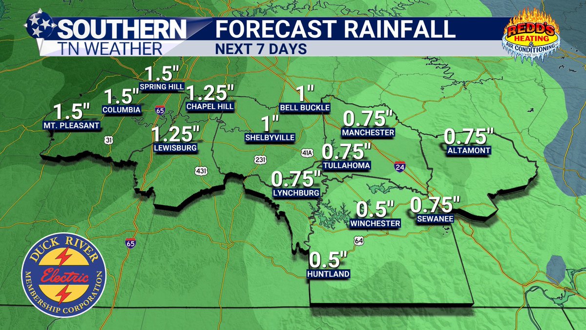
Over the next seven days, most of Southern Middle Tennessee can expect between 1 and 3 inches of rainfall, with the higher end of that range generally favoring western portions of the area closer to Interstate 65. While widespread severe weather is not anticipated at this time, some storms could produce gusty winds, very heavy downpours, and frequent lightning.
Enjoy the weekend sunshine while we’ve got it, because next week’s forecast is looking a whole lot wetter!
━━━━━━━━━━━━━━
🛟 CLEARWATER POOL & SPA, LLC 🫧
Today’s weather update is sponsored by Clearwater Pool & Spa — now under new ownership by Kevin and Jean Tennant! Whether you’re planning a brand-new pool installation, upgrading your backyard, purchasing a new spa or hot tub, or stocking up on chemicals and pool supplies, their experienced team is ready to help get your backyard summer-ready.
🧪 TODAY’S CHEMICAL SPECIAL 🧪
Today’s code word is ESSENTIALS!
Simply mention the code word ESSENTIALS when you stop by Clearwater Pool & Spa (or over the phone) and receive 10% OFF all pool chemicals.
From chlorine and shock treatments to water-balancing products and maintenance supplies, Clearwater has all the essentials you need to keep your pool clean, clear, and ready for summer fun!
📍 857 McArthur St, Manchester
📞 (931) 728-6414
🌐 https://t.co/PMjmcGQqZt
🎡🎶 **FIRST LOOK: BONNAROO 2026 FORECAST** 🎶🎡
We're officially close enough to start talking weather on The Farm!
The good news? At this point, there are no signs of any washouts, tropical systems, or prolonged periods of heavy rain. In fact, this forecast looks pretty typical for mid-June in Middle Tennessee.
Afternoon highs are expected to run in the mid to upper 80s each day, with overnight lows hovering around 70 degrees. That means warm afternoons, mild evenings, and those classic Bonnaroo mornings where you're slowly emerging from your tent wondering what day it is.
As for rain chances, scattered showers and thunderstorms will remain possible each day. That's pretty much the default setting for Tennessee in June. Most of these storms would be the typical summertime "pop-up" variety that develop during the heat of the afternoon and evening before fading away after sunset.
The important thing to remember is that a 30-40% rain chance does not mean it's going to rain all day. That's just how summer storms work around here.
Of course, if you've been to Bonnaroo before, you know weather is part of the experience. One minute you're enjoying sunshine and your favorite artist, and the next you're making a few thousand new friends while waiting out a summer soaker.
The biggest weather concern right now may actually be the heat and humidity. Temperatures in the upper 80s combined with typical Tennessee humidity can make it feel noticeably warmer during the afternoon hours, so plan accordingly and stay hydrated.
It's also important to note that we're still several days away from Bonnaroo. Forecast confidence on specific rain chances, storm timing, and temperatures will continue to improve as we get closer. The forecast will almost certainly evolve between now and opening day, so don't get too locked into the exact numbers just yet.
We'll continue fine-tuning the forecast over the coming days and will have much more detailed information as Bonnaroo gets closer!
⛈️ Why do summer storms seem so random?
NEW BLOG is LIVE
Presented by Heritage South Community Credit Union
One town gets soaked. Another stays completely dry. Sound familiar?
In today's blog, I break down the life cycle of the classic summertime "popup" thunderstorm and explain why these storms can be so difficult to forecast.
☀️ How storms form
🌧️ Why they grow so quickly
💨 How they eventually destroy themselves
📍 Why rain can fall in one neighborhood but miss another entirely
Plus, when shower and thunderstorm chances return to Southern Middle Tennessee.
Read now on the STN Weather App or at https://t.co/oviJHnDO3C
I’m almost positive my friends at Redd"s Heating & A/C left the A/C running outside all night. Because WOW… it felt amazing out there this morning!
Cool temperatures, low humidity, and a nice breeze made it feel a little less like June in Tennessee and a little more like a free trial of fall. Unfortunately, I know good things don’t last forever. Humidity will be making a comeback soon, but we’ll get to that in a second.
First, let’s talk about the latest Drought Monitor that was released this morning.
Some of the biggest improvements occurred across portions of Franklin, Grundy, and Coffee counties, where conditions were downgraded… or is that upgraded? Either way, it’s good news. Those areas have been moved into the “Abnormally Dry” category after spending recent weeks in a Moderate Drought. Not surprisingly, those were also some of the locations that picked up the most rainfall over the past week or two.
Now, I know what some of you are thinking… “How are we still dealing with drought conditions? It feels like it’s rained every other day lately!”
The answer is that drought monitoring looks at much more than just recent rainfall. Soil moisture, groundwater levels, streamflows, longer-term precipitation deficits, and several other factors all play a role. In other words, a few weeks of rain can certainly help, but it doesn’t always erase months of dryness overnight.
Looking ahead, humidity levels will gradually increase through the weekend, and so will our rain chances…
Beginning Sunday and continuing through much of next week, scattered showers and thunderstorms will become more common. This does NOT look like an all-day rain event every day. Think of a fairly typical summertime pattern with scattered afternoon and evening thunderstorms popping up across the region.
We’ll also keep an eye on the potential for a few sneaky thunderstorm complexes (similar to what moved through Monday). Those types of systems can occasionally produce stronger winds and heavier rainfall, but there is absolutely nothing alarming showing up right now, especially this far in advance.
The latest rainfall forecast calls for generally one-half inch to around two inches of rain over the next seven days, although totals will vary greatly depending on where thunderstorms develop and track. One thing to keep in mind: that’s only the next seven days. It doesn’t account for rainfall beyond that period. Current long-range guidance still suggests additional rain opportunities, although the signal becomes a little less impressive after the middle of next week.
I’ll have your first-look Bonnaroo forecast posted later this evening!
__________________________
🔥 REDD’S HEATING & AIR CONDITIONING 🔥
This weather update is proudly sponsored by Redd’s Heating & Air Conditioning — the exclusive heating and air conditioning partner of Southern Tennessee Weather!
For more than 50 years, Redd’s has proudly served our community as a family-owned and operated business. Whether you need repairs, routine maintenance, or a brand-new system, their experienced team is ready to help keep your home comfortable through Tennessee’s hottest days. Give them a call today and tell them Elijah sent you!
📍 704 Blue Ribbon Pkwy, Shelbyville
📞 (931) 684-0339
🌐 https://t.co/yrYcIkaAkS
It’s about that time! First forecast post drops tomorrow evening 👀
It does look like we’ll be dealing with popup showers and storms, but nothing too out of the ordinary for this time of year.
The forecast is changing... even if you can't feel it yet. ☀️➡️⛈️
NEW BLOG is LIVE
Presented by Heritage South Community Credit Union
We've got several more beautiful days ahead, but the atmosphere is already beginning to set the stage for our next pattern change.
In today's blog:
• Why the forecast stays quiet through Friday
• What's happening behind the scenes in the atmosphere
• Why meteorologists are already watching the weekend
• When humidity begins increasing again
• When shower and thunderstorm chances return
Enjoy the sunshine while it's here — summer is slowly starting to make a comeback.
Read now on the STN Weather App or at https://t.co/MlSVOwQ39q
🌞 TODAY IS ABOUT AS CLOSE TO A “CHAMBER OF COMMERCE” DAY AS WE GET AROUND HERE.
Highs in the upper 70s and lower 80s, low humidity, plenty of sunshine, and light winds? Count me in.
While I’m certainly enjoying the beautiful weather (which looks to continue through at least Saturday), we do need to start looking ahead to our next potential period of active weather beginning Sunday and possibly lingering through much of next week.
The latest outlook from the Climate Prediction Center (CPC) for June 9th through 13th places our area in the green shading, indicating an increased likelihood of above-average precipitation.
Now, I share these outlooks fairly often, but what do they actually mean? These outlooks are based on large-scale weather patterns and do not forecast specific rainfall amounts or guarantee rain on any particular day. Instead, they indicate whether the atmosphere is favoring wetter-than-normal, near-normal, or drier-than-normal conditions compared to what we typically see this time of year.
In this case, the green shading suggests the odds are tilted toward a wetter-than-average period across our region. That doesn’t necessarily mean constant rain. Sometimes it only takes a few rounds of thunderstorms or a couple of heavy rain events to push rainfall totals above normal for a given period.
What’s especially interesting is that the CPC continues to highlight our area for above-average precipitation beyond June 13th as well, suggesting this active pattern could persist deeper into the month.
I’m paying particularly close attention to this timeframe because it lines up with Bonnaroo. I know plenty of folks are understandably on edge after last year’s event dealt with periods of heavy rainfall and flooding concerns.
The good news is we’re still more than a week away, which is an eternity in weather forecasting terms. There is plenty of time for details to change. At the very least, however, the current pattern suggests we’ll likely be dealing with a few afternoon and evening showers or thunderstorms during that period. This is completely normal for summertime around here. Nothing out of the ordinary.
For now, enjoy the beautiful weather while we’ve got it. After all, low humidity and sunshine in June don’t stick around forever around here! 😎☀️
_____________________________
🚨 MID-STATE TOWING 🚨
This weather update is sponsored by Mid-State Towing, a locally owned and family-operated towing service proudly serving Coffee County and surrounding communities. Available 24/7, their professional flatbed operators provide fast, dependable towing and emergency roadside assistance when you need it most.
With more than 25 years of experience in collision repair and insurance claims, their team understands how stressful accidents can be and is committed to helping customers every step of the way!
📍 Hillsboro, TN
📞 (931) 247-8068
🌐 https://t.co/wQYGcf1uwg
The Weather We Forgot Existed ☀️
NEW BLOG is LIVE
Presented by Heritage South Community Credit Union
After weeks of storms, heavy rain, and constant radar checks, Southern Middle Tennessee is finally settling into a quiet weather pattern.
In today's blog:
• Why this week's forecast feels so different
• What's making the air so much more comfortable
• How long the dry stretch lasts
• When rain chances begin returning
• Why the radar is about to get pretty boring
Honestly, the biggest weather story this week may be the lack of weather stories.
Read now on the STN Weather App or at https://t.co/PxUPLGilcV
🌦️📱 HAVE YOU CHECKED OUT SOUTHERN TENNESSEE WEATHER BEYOND SOCIAL MEDIA YET? 📺💻
Southern Tennessee Weather has grown into much more than just a Facebook page. Whether you’re at home, at work, or on the go, there are now multiple ways to stay connected to the latest weather across Southern Middle Tennessee!
💻 THE SOUTHERN TENNESSEE WEATHER WEBSITE
Everything you need in one place!
✅ Interactive local radar
✅ Current conditions
✅ Hourly and 7-day forecasts
✅ Live sky cameras
✅ Weather blogs and forecast discussions
✅ Rainfall forecasts and totals
✅ Severe weather updates
🌐 https://t.co/J89ahS3S9O
📺 THE SOUTHERN TENNESSEE WEATHER CHANNEL
Your local weather channel… available 24/7/365!
✅ Live local radar
✅ Current conditions
✅ Forecasts updated throughout the day
✅ Live sky cameras from across the region
✅ FutureCast radar and rainfall projections
✅ Weather headlines and updates
✅ Continuous weather coverage
✅ Severe weather coverage when it matters most
📺 Watch on YouTube: https://t.co/6Cx9mZVPNz
🏞️Download for SmartTVs by searching “Southern TN Weather” on:
• Roku
• Amazon Fire TV
• Samsung TV
📱 THE FREE SOUTHERN TENNESSEE WEATHER APP
Take the weather with you wherever you go! (It works ANYWHERE IN THE US!)
✅ Interactive radar
✅ Live weather channel
✅ Breaking weather alerts
✅ Lightning alerts
✅ Rain and hail notifications
✅ Live sky cameras
✅ Hourly and daily forecasts
✅ Weather blogs and updates
📱 Apple App Store: https://t.co/dMp28l0oRz
📱 Google Play Store: https://t.co/jaaFV16ptx
Best of all? Every bit of it is 100% FREE!
Thank you for allowing me to serve Southern Middle Tennessee. Whether it’s a quiet sunny day or severe weather at 2 AM, I’m proud to be your true local meteorologist, serving Bedford, Coffee, Franklin, Grundy, Lincoln, Marshall, Maury, and Moore Counties with weather coverage specifically tailored to our communities!
Dense Fog Advisory for Bedford, Coffee, Giles, Grundy, Lawrence, Marshall, Van Buren, Warren & Wayne until 9 AM CDT. Vis less than 1/4 mi in dense fog. Use low beams, slow down, allow extra time.
Dense Fog Advisory for Lauderdale, Colbert & Others until 9 AM CDT. Visibilities 1/4 mi or less. Slow down, use low-beam lights, and allow extra time; use caution when driving.
WINDY! Check out this video shared by D’Anna Hope Roberts from downtown Huntland as a severe thunderstorm moved through the region.
While not everyone across Southern Middle Tennessee experienced severe weather today, a few communities certainly picked up a good storm. Wind gusts in and around Huntland were estimated to be in the 40 to 60 MPH range as the strongest part of the line moved through. Scattered tree damage and power outages were reported.
The storms have moved south into Alabama... and for the first time in what feels like forever, the radar is finally about to get boring.
NEW BLOG is LIVE
Presented by Heritage South Community Credit Union
After nearly two weeks of daily storm chances, Southern Middle Tennessee is entering a much quieter weather pattern.
In today's blog:
• Why this morning's storms mark an important transition
• What's shutting down our daily rain chances
• Why this week's forecast may be some of the nicest weather we've seen in awhile
• When rain chances begin returning
The biggest weather story this week may be how quiet the atmosphere becomes.
Read now on the STN Weather App or at https://t.co/HmL44uebHM


![STNWeather's tweet photo. [Weather Alert] Severe Thunderstorm Warning for Franklin, Lincoln, and Moore County until 12:45pm CDT. https://t.co/PUSaK5hQhk](https://pbs.twimg.com/media/HJvhedTWwAAwWQz.jpg)


