Monday evening 6/2: A non-tropical area of low pressure is forecast to form near or offshore of the southeastern U.S. coast within the next 2 to 3 days. The system has a low chance of formation later this week while moving northeastward at 10 to 15 mph.
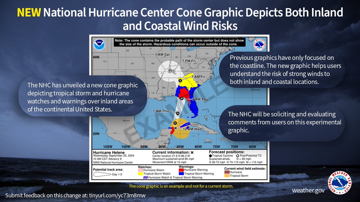
NHC will again issue an experimental version of the cone graphic in 2025 that includes a depiction of inland tropical storm and hurricane watches and warnings in effect for the continental United States https://t.co/LuItOyijFg
8AM EDT Oct 4: We continue to monitor an area with a medium (40%) chance of tropical or subtropical development in the Gulf of Mexico . Regardless of tropical or subtropical development, locally heavy rains could occur over portions of Mexico during the next few days and over portions of the Florida Peninsula late this weekend into next week. Stay updated at https://t.co/Wq6ZtKgfeH
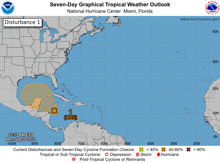
Sep 30 8a EDT: We are monitoring the W Caribbean this morning. Conditions could become more favorable for development in a few days, and there is a medium chance for a tropical depression to form in the NW Caribbean or S Gulf of Mexico late week. https://t.co/tW4KeGe9uJ
Update 6:20 PM EDT Thurs: Helene now an extremely dangerous Category 4 hurricane
A NOAA Hurricane Hunter aircraft currently investigating Helene recently found that the maximum sustained winds have increased to 130 mph (215 km/h). The minimum central pressure has also decreased to 947 mb (27.96 inches) based on dropsonde data.
As #Helene continues to approach the coast, please do not get overly focused on short-term wobbles in its track, "false" eye locations, or on specific computer model simulations.
EVERYONE along the Florida Big Bend coast is at risk of potentially catastrophic storm surge and damaging hurricane-force winds later this evening, and life-threatening storm surge is already increasing along the west coast of Florida.
Continue to follow https://t.co/Wq6ZtKgfeH and https://t.co/AG05fN6p0n for the latest forecast.
@jambrose615 This.
Models are…models. Black boxes. They are made using assumptions which is why they’re not perfect. One must understand the mechanics of storms to make an educated guess like @jambrose615 (i.e. Fujiwara effect).
@mountainwx@TropicalTidbits You can always find local forecasts at https://t.co/jx1DBVezzZ. Tap your county on the map and read the advisories. Always have multiple ways to receive information during severe weather.
https://t.co/lvBrkv7wYe
@TXCoastalSoul@TropicalTidbits Simply put, yes. Imagine a kid going down a slide…the hurricane is the kid and it just made it to the top. Time to slide. The system over the southeast rn is the slide that’s about to pull Helene north like gravity on the kid down the slide. This is it’s about to move quickly.
@cjmoose@TropicalTidbits@Weather_West Also, careful with using Cat ratings to estimate the wind field of a hurricane…or how far the hurricane-force winds will reach. There are many factors that determine the size of a storm including terrain, climate patters, etc. Follow guidance from local officials for safety.
Hurricane #Helene is forecast to be a catastrophic event for some coastal areas of #Florida, with up to 20 feet of storm surge inundation possible, extending miles inland from the coast in some places.
Hurricane force winds are possible over a significant swath of the Florida Panhandle, portions of the western Florida Peninsula, and southern #Georgia, extending well inland. High inland flash flooding risk due to heavy rainfall is also expected over a wide area along the storm track.
Helene is now forecast to be an extreme Category 4 hurricane at landfall. Residents should prepare accordingly.
4PM CDT Sep 25: #Helene strengthens and moves into the southeastern Gulf of Mexico. Preparations to protect life and property from storm surge and damaging winds along the Florida Big Bend Coast need to be rushed to completion today. Check back frequently for updates at https://t.co/Wq6ZtKgfeH