The "Sborka" plant in Voronezh, Russia, which manufactures parts for "Pantsir" air defense systems, as well as "Iskander-K" and Kh-101 missiles, is looking a bit under unwell after a visit from Ukrainian birds 🔥
@MonolithSin@mukanjyoo@CloudPlays_YT@mukanjyoo did you stop playing? Serious question, because the game went through a re-buff phase too and they made a lot of weapons viable again or for the first time.
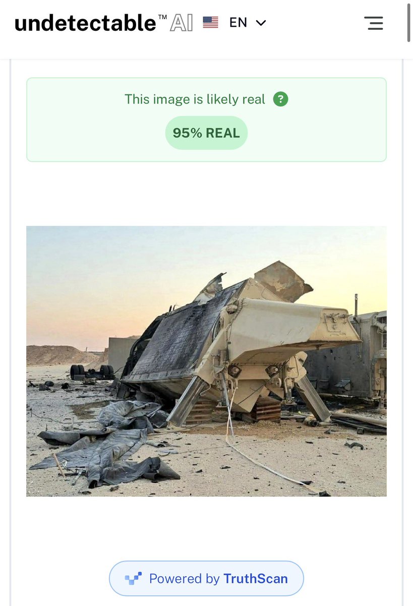
For everyone who thinks this image might be AI
1. I put the image through five different AI checkers, and all five said the photo was about 95% likely to be real and not AI-generated.
2. Looking at the satellite imagery of the strike, the surrounding structures, including the fire, the pattern of the dust around the site, the position of the tarp on the ground, the position of the equipment behind the radar, the position of the hill, the position of the wall, and the area of damage are the same in the satellite imagery as in the photo. The ground patterns match, and you can also see the rubber tarp-like material coming out of the structure, which appears the same in both the satellite view and the photo.
3. The reason you don’t see a large amount of fire in the photo is due to the angle from which the photo was taken. As seen in the satellite imagery, if the photo were taken from the front of the AN/TPY-2 radar, you would be looking directly at the fire. However, since the photo is taken from the more intact side of the radar, the structure itself blocks the view of the fire, which occurred mostly behind the radar and on its left side. Additionally, the electronics equipment unit positioned behind the radar not only matches the correct position but also shows no damage on the right side, as seen in satellite imagery and the photo. Also, there are wheels behind the radar, at the correct distance and angle from it.
4. I spoke with an account that specializes in US weapons systems. They confirmed that the photo is most likely real because the parts on the radar, including the bolts, the frame, the mechanism that allows the radar to adjust its elevation angle, and other parts, are exactly as they should be in the image. Equipment positioned behind the system is exactly how it would appear in a real combat deployment. The radar and system components match the actual AN/TPY-2 configuration.
The damaged section where the drone hit also matches the same part that appears damaged in the satellite imagery, and the surrounding equipment placement lines up as well.
Overall, there are simply too many specific features that AI would have to generate consistently to match detailed system components, the area of damage, and dozens of other features and objects in the environment and from the damage, as seen in the satellite imagery. AI images often distort equipment or make several inaccuracies, and they usually don’t match satellite imagery and complex system components this precisely. Since it is already confirmed that the radar was destroyed, the photo appearing “too clean” is most likely explained by the viewing angle and the desert environment, where you see more dust on the ground and less visible flame because of the direction the photo was taken from, since the fire damage is behind it and on the other side.
All that, paired with the fact that all 5 AI software tools confirmed the image was 95% real, with all that evidence, I conclude that the image is likely authentic and not AI-generated.
@heatloss1986 @AirPowerNEW1 what else in the image tells you its AI other than the blocks, and in comparison to the satellite image of the supposed strike location?