Ela nasceu no japão, saiu de seu país sendo de menor para realizar seu sonho, volta com uma perfomance com vestimenta japonesa, musica por uma japonesa, cenário com referencias japonesas em frente de 45K de pessoas em seu país natal
INSTEAD OF WATCHING NETFLIX TONIGHT. Spend 2 hour with this. Claude AI FULL COURSE that teaches you how to BUILD and AUTOMATE anything. The people who watch this tonight will wake up tomorrow with a new skill. Watch it and bookmark it now.
This scene really means so much to me, it’s nice that they finally managed to represent Hutts as more than just fat crime bosses, 'cause they used to be absolute brutes. This is a rare modern-day adaptation of Disney looking at the older Star Wars lore and putting it into their work.
Most people don’t even understand just how powerful a Hutt really is. Their entire culture used to be dominated by warriors. It was only about thousands of years before this movie takes place that the Hutts moved to criminal acts.
Monster Fantasy looks like a mix of monster hunting, farming-life vibes, and co-op adventure.
• Battle 50+ giant monsters
• Tame and evolve your own companions
• Ride monsters across the world
• Fish, cook, craft, and mine
• Meet villagers and build relationships
• Online co-op support
> Launching its Kickstarter campaign on July 15.
Keeping an eye on this one? 👀
#MonsterFantasy
A 21-YEAR-OLD FROM CHINA RUNS 300 AI AGENTS AT ONCE. THE PART THAT MATTERS ISN'T THE SPEED, IT'S THAT NONE OF THEM CAN LIE TO HIM
he opens the dashboard and shows the swarm live, 300 Kimi K2.6 agents firing in parallel, then Opus 4.8 checking every single output against its source. this is not just a faster swarm. it is a loop that refuses to stop while anything is still wrong
he pointed it at 100 EV-market companies. first pass: 12 failed. wrong revenue, dead citations, empty fields. second pass: 3 failed. third pass: zero
this is not another agent demo. it is a system that catches its own mistakes before he reads a single row
When Vietnam did what the West failed to do.
On Christmas Day 1978, 150,000 Vietnamese troops stormed into Cambodia and crushed the Khmer Rouge regime of Pol Pot, the architect of one of the 20th century’s most horrific genocides, which slaughtered nearly one-quarter of Cambodia’s population through mass executions, starvation, forced labor, and disease.
In just two weeks, Vietnamese forces, backed by Cambodian dissidents, seized Phnom Penh and toppled the brutal government, effectively ending the killing fields.
Yet, in a stunning display of Cold War cynicism, remnants of Pol Pot’s forces fled to the jungles and waged a decade-long guerrilla war, bankrolled primarily by China and covertly supported by the United States and Thailand.
These nations supplied the Khmer Rouge with weapons, training, logistical bases, and even diplomatic legitimacy at the United Nations, giving a lifeline to the very perpetrators of genocide.
What began as a military intervention that stopped a genocide in its tracks was condemned as “aggression,” while those who armed its survivors were hailed as defenders of “freedom.” History has rarely seen such moral inversion.
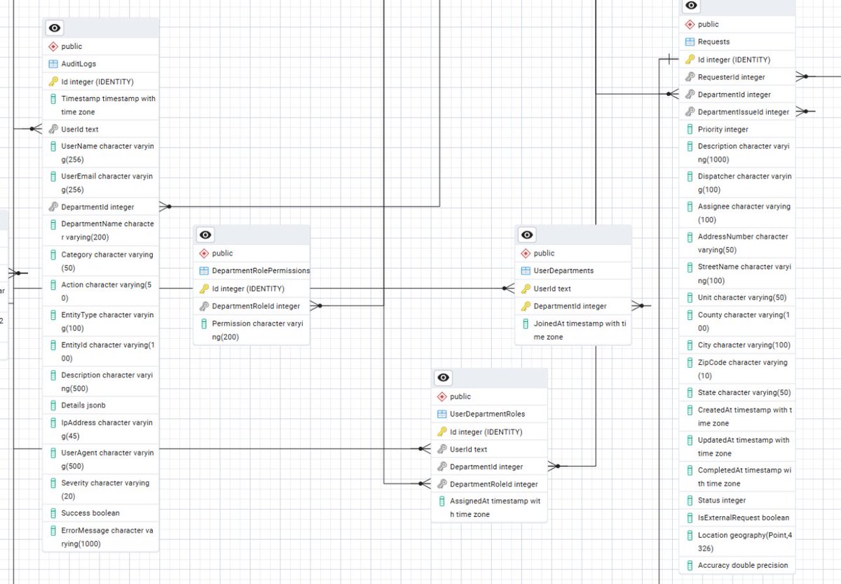
GIS Advice: Elevate Your Skills & Vector Data with a Relational Geospatial Database Like PostgreSQL with PostGIS extension.
Do not settle for scattered shapefiles or adhoc file storage. Commit your vector GIS data (points, lines, polygons, and their attributes) to a robust relational geospatial database, such as PostgreSQL with the PostGIS extension. This is not just a "nice to have" item. It is the foundational upgrade that transforms chaotic data management into scalable, query friendly intelligence.
-----------------------------
The Case for Relational Geospatial Power
At its core, vector GIS data thrives on structure such as geometries intertwined with rich attributes like timestamps, classifications, or metadata. A plain relational database (RDBMS) handles the tabular side beautifully, enforcing relationships, ensuring data integrity, and enabling lightning fast SQL queries. But without geospatial smarts, your polygons are just awkward binary blobs. Those polygons are impossible to intersect, buffer, or analyze efficiently.
Enter PostGIS, the open source spatial extension for PostgreSQL, which turns PostgreSQL into a geospatial powerhouse. It adds native support for:
1⃣Spatial Data Types: Store geometries as GEOMETRY or GEOGRAPHY columns, complete with SRID (Spatial Reference ID) for coordinate systems like EPSG:4326 (WGS84). Store topologies along with rasters...Need I say more?
2⃣Advanced Indexing: GiST (Generalized Search Tree) or BRIN indexes for blazing-fast spatial queries—think sub second results on datasets with millions of features.
3⃣Rich Function Library: Over 300 functions for operations like ST_Intersects(), ST_Buffer(), ST_Union(), or even raster support via extensions. Want to calculate the area of overlapping flood zones? One query does it.
PostgreSQL as the base is a no brainer. PostgreSQL is free, battle tested/harden (powers everything from NASA datasets to Uber's mapping), infinitely extensible, and scales from laptops to cloud clusters ( AWS RDS or Google Cloud SQL). In 2025, with GIS workloads exploding due to AI integrations and IoT sensors, this stack remains the gold standard and is endorsed by Esri, the Open Geospatial Consortium (OGC), and communities like OpenStreetMap.
On that note, why are you not using PostgreSQL with PostGIS and stepping up your game? It is time to move out of your comfort zone(shapefiles/file geodatabase) and start using the tools that professionals utilize.
Learning PostgreSQL with PostGIS is the key skill upgrade that will complement your GIS toolkit, which will help you unlock doors to a thriving career or that well deserved promotion.
On that note, keep on analyzing and studying!!!!
GIS Career Tip: Level Up Your Skills with Geospatial Relational Databases
If you are aiming to become a GIS Technician or Analyst, mastering relational databases like PostgreSQL with the PostGIS extension is a game changer. Sure knowing how to wrangle file geodatabases (.gdb) or shapefiles is a solid foundation but it is where most general level work lives. But to truly differentiate yourself and boost your marketability, dive into geospatial relational databases (RDBMS) like PostgreSQL/PostGIS or Microsoft SQL Server with spatial extensions.
Real World Edge
1⃣Scalability for Big Projects: File formats choke on large datasets or multi user edits. RDBMS handle terabytes, concurrent access, and complex queries without breaking a sweat. It is perfect for Enterprise GIS roles in government, utilities, or tech. Large companies, Cities, utilities utilize Relational Databases and the more you know about this topic, the greater of your chances are landing a job within a large entity, which generally pays more.
2⃣Advanced Analytics: Unlock SQL powered spatial magic, like ST_Intersects for overlay analysis or ST_Buffer for proximity modeling. This is not just data storage, it is a toolkit for automation and insights. Demonstrating these types of concepts are sure to help you get your foot in the door.
3⃣Job Market Boost: Listings on Indeed/LinkedIn scream for "RDBMS experience." By demonstrating your skills with geospatial relational databases(GRD), you give a signal to your employer or future employer that you have one piece of the puzzle that makes you ready for a GIS Analyst + role.
Keep analyzing, learning and building those skills!!