Where is sulfur (S) in the Earth's mantle? Sulfides of course! But can silicate minerals store some S during mantle melting? Can we measure trace S in silicates using EPMA? @RiceEarthSci@RiceNatSci PhD student Anna Johnson's recent paper has some answers.🌋
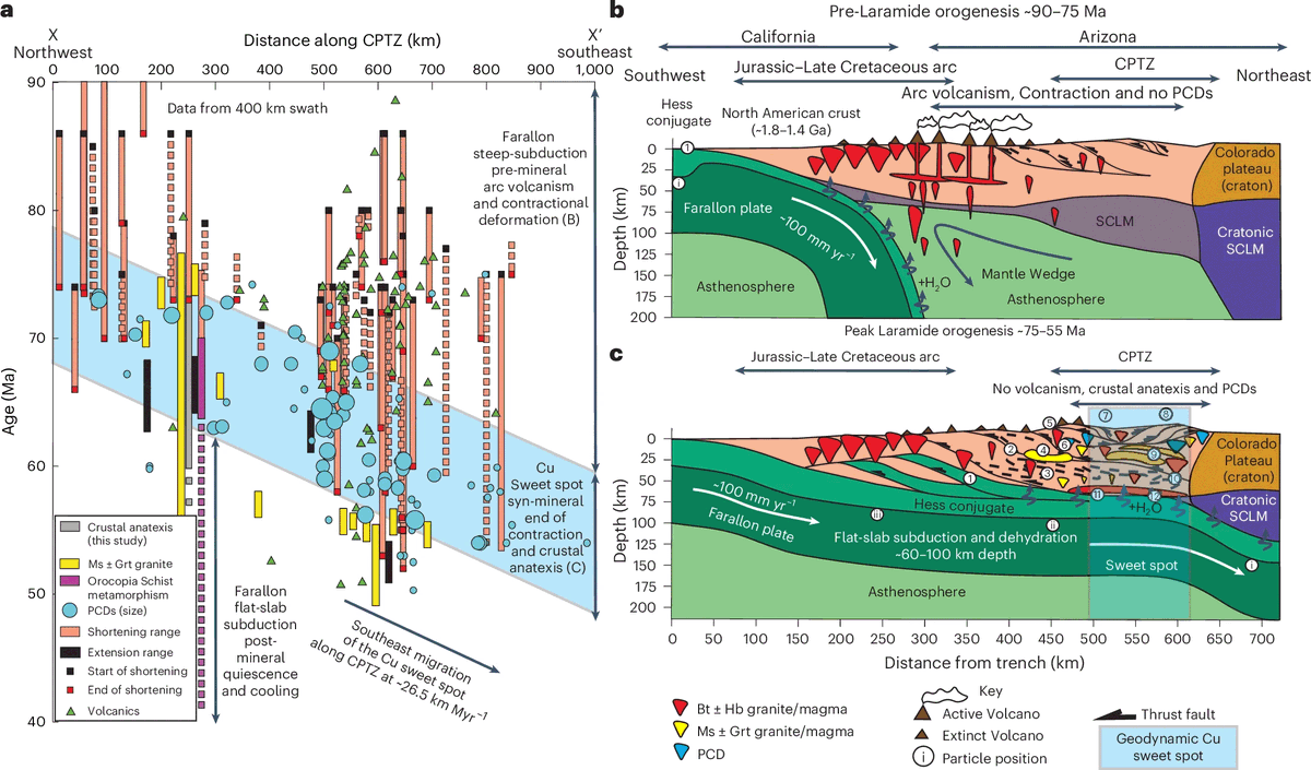
A team of int'l geoscientists recently used geochronology & thermobarometry to investigate deep crustal processes during the genesis of the Late Cretaceous–Palaeocene Laramide Porphyry Province in Arizona: https://t.co/W1xcbpM1ed
#Geochronology#Geoscience#GeologyRocks
Super article by @WeiPoints on drilling underneath the ocean floor into the earth's mantle rocks.
The abiotic and biotic reactions taking place during rock alteration are of interest to origin of life researchers.
https://t.co/RUUvxbeZfe
A new video on Volcanogenic Massive Sulphide (VMS) deposits now online https://t.co/c09G2qR3cV
on my Youtube channel "Our Metallic Earth" https://t.co/INyrYGInvN
VMS deposits are a significant source for #Lead#Zinc#copper#cobalt#GOLD and #Silver
More videos coming in 2024!
Elveda ChatGPT!
Artık yapay zekayı kullanarak kendi özel ChatGPT'nizi oluşturabilirsiniz.
Kodlama gerekmez.
Droxy AI ile kendi yapay zeka arkadaşınızı/çalışanınızı nasıl oluşturabileceğinizi gösterdim:
[🔖Kaydedin lazım olur.]
Interested in the phosphorus cycle? How about sulfur? Anoxic oceans? The productivity of the marine biosphere through time? Then check out this new GRL paper, which touches on all that & more.
In case 4000 words is too long, here’s a recap in 7 tweets
https://t.co/yJZ64JIdpM
@kirstenology@Annebalme If mineral deformed or/and rimmed by the another minerals as a result of fluid-rock reactions, you can say unhappy for this. If still fresh!! So it's happy 😀
Do you generate LAICPMS data and wish all those pesky csv files were just one spreadsheet? Well do I have an incredibly niche tool for you…multifiler is designed to do literally ONLY that. But wow is it good at its job. https://t.co/pxsSKmgSVA
Klasik altlık haritalardan sıkıldıysanız, ArcGIS Online'da birbirinden farklı haritalar oluşturabilirsiniz. Şehirlerin, nehirlerin ve diğer coğrafi özelliklerin benzersiz ve göz alıcı bir şekilde tasvir edildiği bu haritayı keşfetmek için: https://t.co/ZiuZw8eXFn
#ArcGIS #cartography