Director, Viz Center, privileged 2 work w wonderful team 2 help in disaster response, esp w geospatial mapping, mobile devices, & in austere settings 2 help ppl
#SDSU watching the status of #SageFire near Jamul east of #SanDiego on Thanksgiving afternoon. Imaged on #GOES satellites in afternoon & shown on #WIFIRE https://t.co/9hskT380xk where can see high humidity (in 80's) & low wind (< 5mph) & cool temps (50's) so hope 4 Firefighters
#SDSU also watching fire in #CampPendleton on Tues. evening on #WIFIRE https://t.co/9hskT380xk and imaged this afternoon on several satellites. Winds low, so hopefully can make major impact tonight.
#SDSU looking at multiple cameras from #HPWREN imaging #HighlandFire to see strong winds so smoke going sideways, not up. Can also predict where fire is going from where smoke blowing, but wind will change later in day. Really worth monitoring esp. for ppl in area
#SDSU looking at multiple cameras from #HPWREN imaging #HighlandFire to see strong winds so smoke going sideways, not up. Can also predict where fire is going from where smoke blowing, but wind will change later in day. Really worth monitoring esp. for ppl in area
camera looking South, can see strong wind. Abt 8:30am Tues.#SDSU monitoring the #HighlandFire east of #Temecula from #WIFIRE (https://t.co/9hskT380xk) 2 see where satellite imagery thru night has been, weather & wind & cameras. This is @HPWREN camera at abt 8:32am showing wind.
#SDSU monitoring the #HighlandFire east of #Temecula from #WIFIRE (https://t.co/9hskT380xk) 2 see where satellite imagery thru night has been, weather & wind & cameras. All under layer icon on top right. This is @HPWREN camera looking South, can see strong wind. Abt 8:30am Tues.
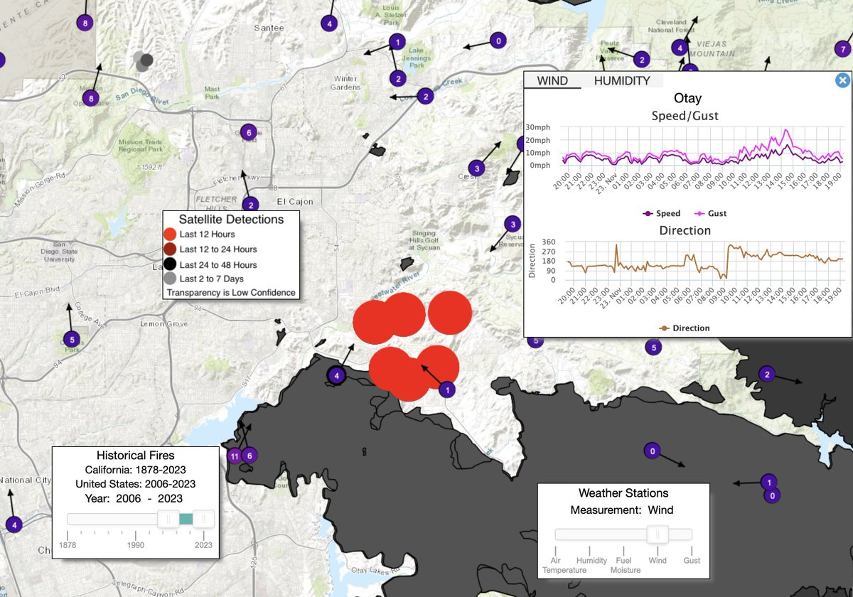
#SDSU monitoring the #HighlandFire east of #Temecula from #WIFIRE (https://t.co/9hskT380xk) 2 see where satellite imagery thru night has been, weather & wind, topography, historic fires, cameras. All under the layer icon on top right. Wind to west at 8:20am, will pick up soon.
#SDSU monitoring the #HighlandFire east of #Temecula from #WIFIRE (https://t.co/9hskT380xk) 2 see where satellite imagery thru night has been, weather & wind, topography, historic fires, cameras. All under the layer icon on top right. Powerful tool 4 predicting what could happen.
#SDSU really impressed by the power of @FirePhotoGirl videos showing reality of fire from very strategic vantage points--incredible assistance 2 understanding the danger & challenge to FireFighters. Being in front of this fire could be deadly--so how to stop with #SantaAnaWinds ?
#SDSU again really benefiting from incredible photojournalism of @FirePhotoGirl with her images of the #Highland Fire east of #Temecula. With #SantaAna winds today, fire is likely to be major challenge for FireFighters 2 stop & keep from ppl & structures. Really worth watching!
#SDSU watching on Twitter 2 see eyewitness views of #Hilary and its impact on #Baja. Incredible benefit of seeing what others are experiencing as storm advances 2 San Diego & Imperial Valley campuses. Impressive efforts of campus leaders 2 prepare & protect students & community!
#SDSU monitoring Hurricane #Hilary on #Ventusky https://t.co/OiC1OIa5R7 to see where prain will likely be, wind, lightning, waves, air pressure. Powerful to step thru time & location & can mouse over 2 get value as 4 amount of rain. See time at bottom on big view 2am Mon. LA hit.
#SDSU monitoring Hurricane #Hilary on #Ventusky https://t.co/OiC1OIa5R7 to see where precipitation will likely be, wind, lightning, waves, air pressure. Powerful to step thru time & location & can mouse over 2 get value as 4 amount of rain. See time at bottom on big view 11pm Sun
#SDSU monitoring Hurricane #Hilary on #Ventusky https://t.co/OiC1OIa5R7 to see where precipitation will likely be, wind, lightning, waves, air pressure. Powerful to step thru time & location & can mouse over 2 get value as 4 amount of rain. See time at bottom on big view 8pm Sun.
#SDSU monitoring Hurricane #Hilary on #Ventusky https://t.co/OiC1OIa5R7 to see where precipitation will likely be, wind, lightning, waves, air pressure. Powerful to step thru time & location & can mouse over 2 get value as 4 amount of rain. See time at bottom on big view 5pm Sun.
#SDSU monitoring Hurricane #Hilary on #Ventusky https://t.co/l694DCyGG4 to see where precipitation will likely be, wind, lightning, waves, air pressure. Powerful to step thru time & location & can mouse over 2 get value as for amount of rain. #ImperialValley--huge impact. 2pm Sun
#SDSU watching the approach of Hurricane #Hilary as comes up #Baja. Wind & rain on both sides, looks like really immense impact on Sat. & esp. Sunday. One of aspects driving storm is temperature of water. On https://t.co/F89VpjF1OK can see hot water in #Gulf & cold water 2 west.
#SDSU watching the predicted advance of Tropical Storm/Hurricane #Hilary as projected on Ventusky https://t.co/l694DCyGG4 to drop several inches of rain on NE #Baja & #ImperialValley & western Ariz. Step thru time & watch rain, wind, lightning, waves, air pressure 2 help predict.
#SDSU continuing to monitor the #CoyoteFire near #Potrero & north of #Tecate as FireFighters & air crews made huge progress with aid of calm winds. LosPinos South PTZ camera from #ALERT#SDGE shows much smaller fire, smoke going up #WIFIRE https://t.co/9hskT37sHM wind picking up.