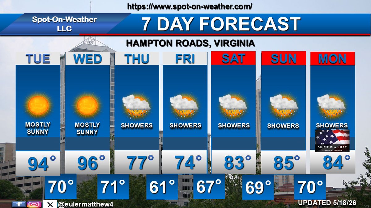
A pleasant start to the work week on MON and TUE with lots of sunshine and daily highs in the middle to upper 70s. Much warmer WED through next weekend with daily highs jumping into the lower 90s. Isolated PM storms on WED and THU, then scattered PM storms FRI through SUN.
A cold front drops into SE Virginia late SUN with isolated storms. High pressure briefly builds in MON with high temps cooling into the upper 70s. High pressure moves offshore TUE. South to Southwest winds, hotter temps, and isolated to scattered storms are expected WED thru FRI
A pleasant, breezy early June day is expected on TUE. High pressure remains in control WED and THU with warmer temps. Hotter temps arrive FRI through SUN. The next chance of showers is late SUN and MON as a backdoor cold front drops into the area from the north.
Good Evening Everyone. We have an updated schedule for the Weather Confessions podcast. We will be recording Episode 4 next Wednesday, 03 June. It will be available for viewing on Wednesday, 10 June. Looking forward to discussing flooding with a special guest @CodyBarnhartWx
In this video, I cover the Arctic and North Atlantic teleconnections and discuss some notable past United States winter seasons.
https://t.co/osl5O52dyD
A stationary front will be draped across the area from TUE into THU AM with scattered showers and storms. Not everyone will get wet on these days. A cold front pushes south of Hampton Roads on THU with drier air filtering in for FRI through the weekend. Temps cool into the 70s.
Scattered storms are expected from Memorial Day through WED along a stalled frontal boundary. Lingering showers are possible into THU AM. High pressure builds into SE VA THU afternoon through SAT with drier conditions and slightly cooler temps.
Unsettled weather is expected across Hampton Roads from SUN through WED with daily chances for scattered showers and thunderstorms close to a stationary front. All-day washouts are not expected. A front pushes south of the area by THU with drier air moving in late week.
Hot weather on TUE and WED with lots of sunshine. A cold front drops across SE VA on THU AM with showers, cooler temps & onshore winds. The front remains south of the area on FRI before returning back north with warmer temps in the 80s for the weekend. Unsettled FRI thru MON.
The heat will remain in place through WED as persistent south-southwest winds blow across SE VA. A cold front makes its way through the area on THU AM with much needed relief. The front will stall out near Hampton Roads from FRI through the weekend with shower chances each day.
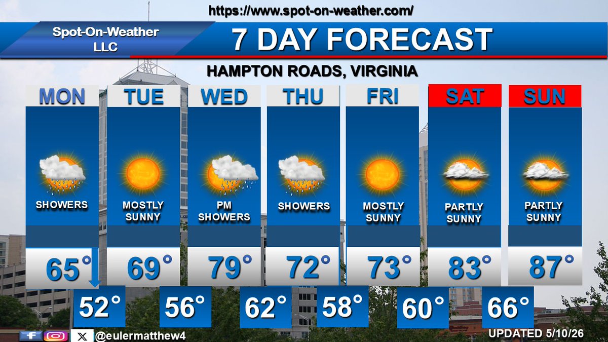
A cold front moves through the area MON with showers. Temps fall from the middle 60s during the afternoon. Mostly sunny TUE. Warming temps with showers WED. Cooler temps on THU before a warming trend next weekend.
Mostly sunny and very warm on Mother's Day. A cold front moves through Hampton Roads MON with cooler temps and showers. High pressure produces pleasant weather on TUE. The next cold front approaches WED with another round of showers, lingering into THU. Pleasant FRI, warmer SAT.
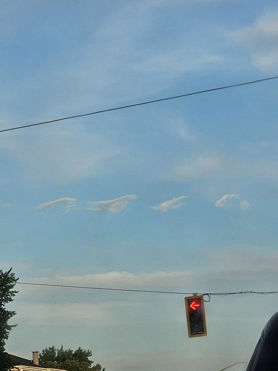
Want to know about clouds and the weather? I cover cloud types across the seasons and what type of weather to expect with each cloud type in this comprehensive video. @NWSWakefieldVA@wxmanricky
https://t.co/nO2HPZKMq7
April 2026 Weather for VA Beach
Mean Temp: 63.7 F (+3.6 F)
Max Temp: 92.1 F on the 15th
Min Temp: 39.5 F on the 21st
# of 90 degree days: 2
Total Rainfall: 1.55" (-1.82")
Max Daily Rainfall: 1.12" on the 5th
Heating degree days: 168.3
Cooling degree days: 128.8
@NWSWakefieldVA