Delivering NOVA’s most reliable school closure forecasts!
FCPS alum | Not affiliated with FCPS | Loves Snow
Instagram: @fcpsclosureodds
Link in bio for more!
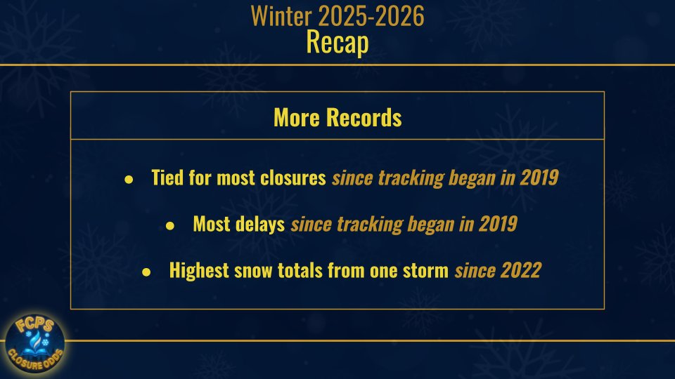
I always like to be sure but I think that we can officially call this winter season over! Thank you for following along, it was a fun year! Back into hibernation I go! (unless we get another thunderstorm closure😂)
Below are your stats for this season, and as always
#closefcps
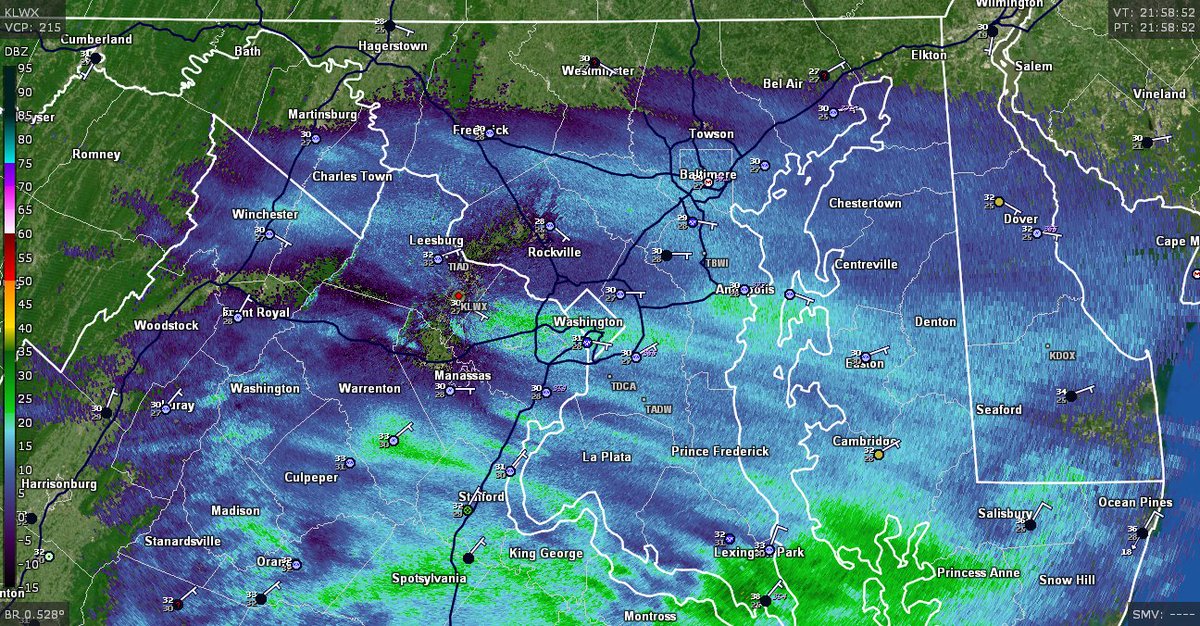
Tornado Watch DROPPED early for the bulk of the DC region.
Was set to expire at 7pm originally, but with the current line advancing east towards the Bay...there should be a several hour lull in the action here.
Still expecting another line later tonight with the front crossing.
SPC notes: "The tornado watch will be cancelled in the wake of this line of storms. Some threat for damaging convective winds with the front this evening still persists, but will be handled with an additional watch later this evening if necessary."
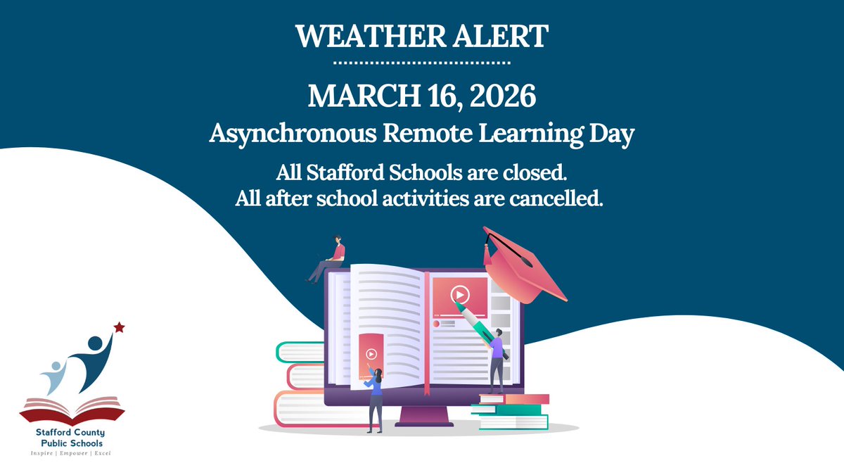
WEATHER ALERT FOR MONDAY, MARCH 16, 2026
All FCPS schools and offices will close three hours early on Monday, March 16, 2026 due to possible severe weather. Additional details at https://t.co/pybAQOAoiW.
I was literally typing out my predictions as this came out, the graphic was ready and everything. Anyways, make sure you have a severe weather plan should anything serious come your way and stay informed!
All schools and offices will be closed tomorrow, March 16, 2026. All after school activities are cancelled.
Students and staff will engage in asynchronous remote learning, with submission of assignments counting toward attendance.
MCPS is monitoring the potential for a strong storm for Monday, March 16, and will announce any updates concerning operations, including any cancellations of activities or an early dismissal on Monday morning.
Visit the MCPS website for more information.
Looks highly likely to me that activities will be cancelled. Early releases can be in play but I am over my head predicting these kinds of things for non-winter storms. Everyone stay safe!
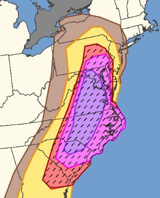
A VERY DANGEROUS SEVERE WEATHER OUTBREAK is likely tomorrow...
Widespread damaging winds between 60-80 MPH and several tornadoes will be possible all day, with semi-discrete and discrete supercells producing the risk of tornadoes and wind, while a line of storms develops out west, with widespread damaging winds likely. Pictured is the damaging wind risk, and in the purple, a 60% CHANCE of damaging winds exists within a 25-mile radius. Anywhere in the red, pink, and purple, could see numerous to widespread damaging winds on Monday.
We don't see events like this often, especially in March. Stay tuend for updates and spread the word on this very concerning threat.
Washington D.C. and Mid-Atlantic gang – please read this writeup for Monday's severe weather potential.
To put it into perspective, I'm likely going to fly *back home* from the Midwest for this.
Here’s a quick update on tomorrow’s storm (how is this even happening after 80 degrees today 🤣). The storm has the slim potential for heavy snow in the area. However, impact would be very limited due to ground temps so I expect no changes to operations.
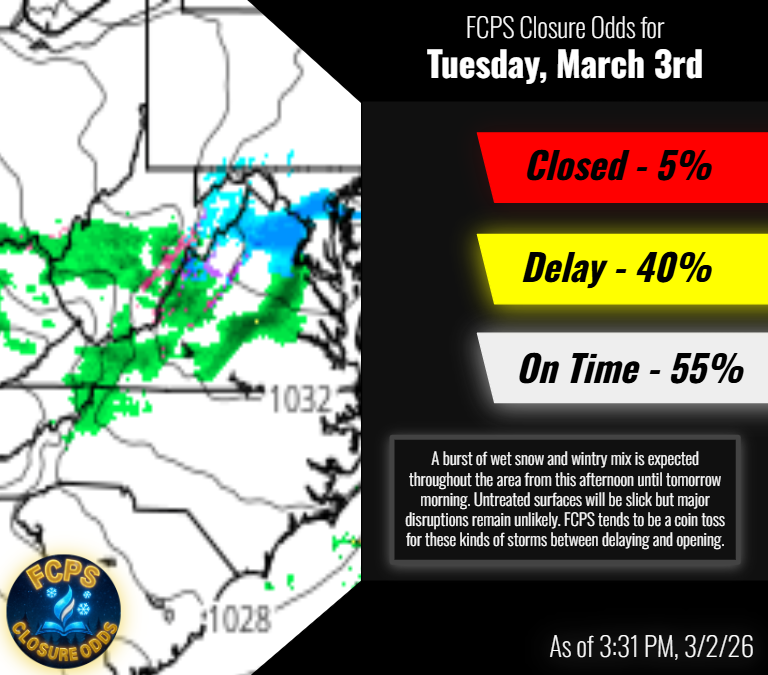
❄️ WEATHER ALERT FOR TUESDAY, MARCH 3, 2026
All FCPS schools and central offices are on a two-hour delay Tuesday, March 3. Details at https://t.co/pybAQOAoiW.
Loudoun County Public Schools will open on a two-hour delay on Tuesday, March 3, 2026. Admin offices will open on time. For more info: https://t.co/cEap40dWsE
FCPS Closure Odds for Tuesday!
All options are on the table but a transition from mix to rain in the morning makes closures unlikely. Historically with storms like this, FCPS has leaned towards opening but we are still very much in the mix for this one (get it?)
#closefcps
5:05 pm: Steadiest snow is over, as is accumulation in most of the area. We'll see it end over the next hour or so, soonest north and west. A snow shower not impossible after that this evening but won't amount to anything.
Temperatures in the upper 20s and low 30s could promote a couple slick spots but roads mainly wet. Should be as cold as it gets tonight right now.
Wintry mix turning to freezing rain and rain late night. Main impact north and west of I95, likely minor.