WAFB Tropics Watch: Saturday 8PM
Peter & Rose on the way?
- Invest #95L likely to become #TD16 - or possibly #Peter - within the next 12-24 hours
- #97L has been steadily organizing over the past couple of days
- neither a threat to the Gulf
Tuesday 10PM:
Nicholas & RainCast Update
- Nicholas will spend two days "pub-crawling" SW & SC Louisiana
- WPC indicates a BIG rainfall potential on Wednesday ... with rains continuing to accumulate right through the weekend
#WAFBFirstAlert
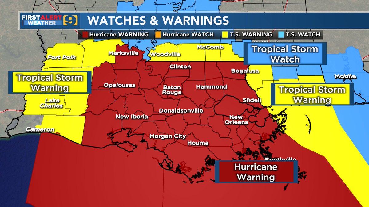
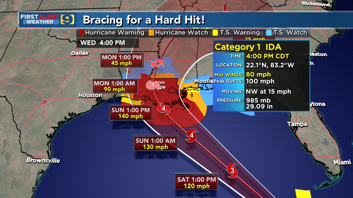
Ida now a major hurricane, a cat 4 packing sustained winds of 130 mph, approaching the northern gulf coast. This system is
expected to continue NW with a turn to the north northwest later this morning, making landfall as a category 4 this afternoon. #MSWX#LAWX
After a pretty significant right wobble this afternoon, it looks like #Ida is very near the official forecast track again tonight (just slightly right of track).
At this point, appears likely metro Baton Rouge gets into the core of the storm, whether overhead, just W, or just E.
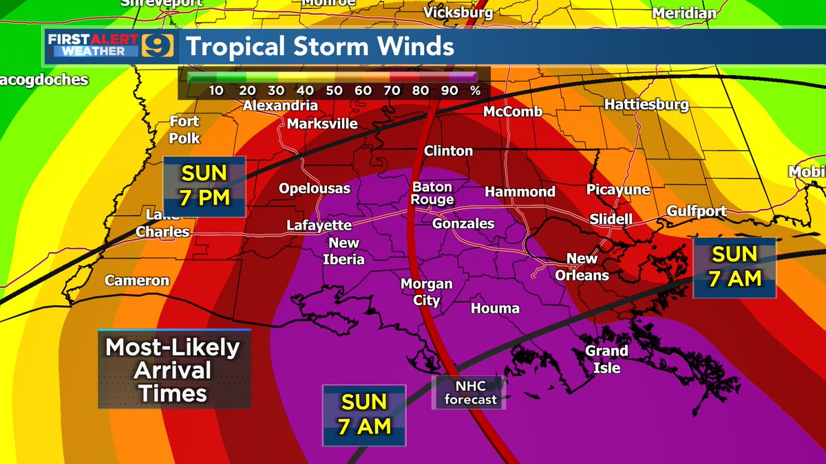
Fresh evening 00z spaghetti models. Track still very certain. NHC expecting Cat 4 IDA nearing landfall later Sun. Effects will be felt way earlier. Very serious storm with catastrophic damage expected. 140mph sustained winds officially in the forecast and 10-15 foot storm surge.
In 25 years of TV broadcasting ... I have never presented a more worrisome tropical forecast for the WAFB area. Ida has the potential of being more troublesome than 2008's Gustav, more problematic than 1992's Andrew."
Get your final hurricane preps completed ASAP!
Jay
Our local rivers are a foot or less below flood stage as of today. The east wind has been pushing in on us. Unfortunately, this isn’t going to help us much when the storm surge gets here. Be prepared!!
On this 5th anniversary of the 2016 flood, here's a ~60 hour radar loop I put together showing the relentless rains.
Rainfall totals topped 30" in places such as Watson.
Multiple rivers experienced record flooding.
Damage estimates range from $10-$15 billion. #LAwx
LIX issues Marine Warning [wind: >34 KTS, hail: 0.00 IN] for Lake Pontchartrain and Lake Maurepas [GM] till Aug 1, 7:45 PM CDT https://t.co/A0KZitZ9ik
Friday PM QuickCast (60 sec)
- mid 90°s will 'feel like' 105° or more!
- not record heat ... but possibly the 'hottest' days of the year so far
- be SMART! ... take breaks, stay hydrated
- eyes on the kids, the elderly, and the pets too!
#WAFBFirstAlert


![iembot_lix's tweet photo. LIX issues Marine Warning [wind: >34 KTS, hail: 0.00 IN] for Lake Pontchartrain and Lake Maurepas [GM] till Aug 1, 7:45 PM CDT https://t.co/A0KZitZ9ik https://t.co/R8Ha4D6pGd](https://pbs.twimg.com/media/E7viwldVIAMf15R.jpg)


