Top Tweets for #WAFBFirstAlert

Radar and Satellite can show us more than just rain . . .
#WAFBFirstAlert
#WAFBFirstAlert: Thursday 9:50 AM
Thin cirrus cloud deck creating this bright “solar halo” … as seen from SW EBR.

Mother Nature’s art work!
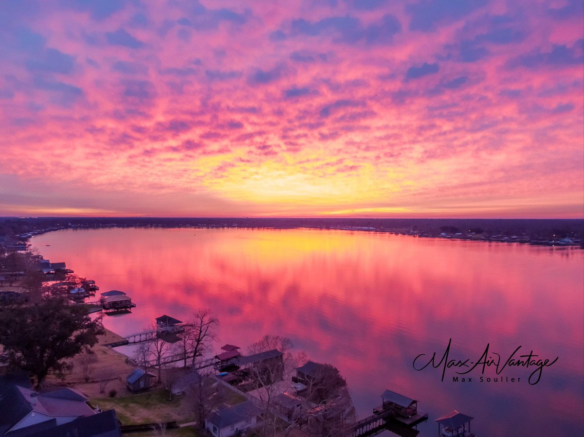
False River, Thursday morning …
Courtesy: Max Soulier
#WAFBFirstAlert
Wednesday Morning ISS Fly-Over
- skies should cooperate for a nice 6+ minute fly-by of the ISS from SW to NE ... passing almost directly overhead at about 6:21 AM.
#WAFBFirstAlert

After a record warm summer and temps remaining above-normal for much of the past few weeks ... I've been frequently asked, "Are we finally done with those 90°s?"
Just remember ... it's weather ... "Never say never."
#WAFBFirstAlert

Friday Evening QuickCast
- feeling like fall this weekend
- breezy for both days, especially in the afternoons
- mainly-dry cold front slides thru early Saturday
- morning lows in the 40°s for Tuesday & Wednesday
#WAFBFirstAlert
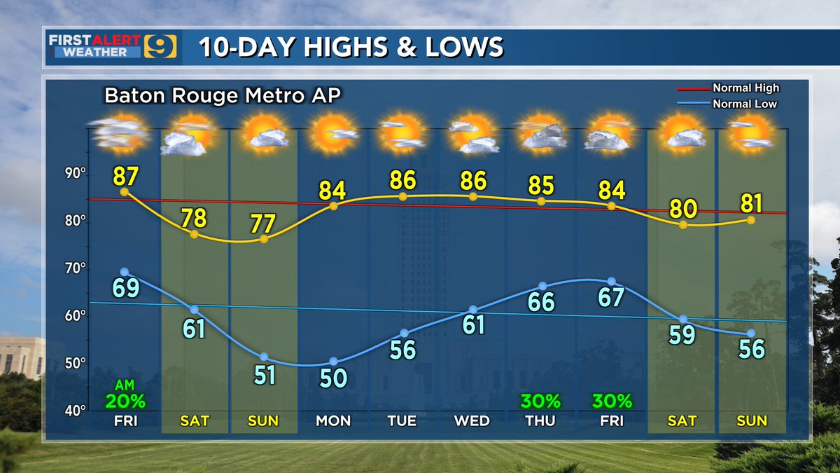
Thursday Evening QuickCast
- highs could reach the upper 80°s on Friday
- early morning "dry" cold front on Saturday
- cooler and sunshine for both weekend afternoons
- dry weather persists through most of next week
#WAFBFirstAlert
WAFB FIRST ALERT:
U.S. Drought Monitor (USDM) Thursday Update
Did Wednesday's rain take a bite out of the local drought?
#WAFBFirstAlert

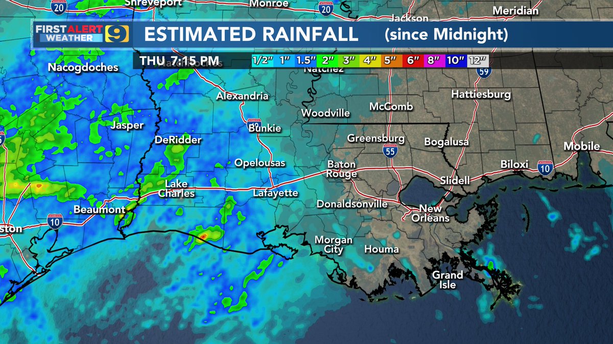
Wednesday Evening QuickCast
- Wednesday rains of 0.5" to 1.5" for much of the WAFB region
- good start but far from a drought-buster
- mostly-dry cold front on Friday leads to a nice autumn weekend
- unfortunately, mainly-dry thru the next 7 to 10 days
#WAFBFirstAlert
Monday Evening QuickCast
- dry Tuesday ... wet Wednesday
- possibly 1" to 2" near/along the coast
- early guidance suggests less than 1/2" for areas north of I-10/12
- add low-end rain chances in the forecast for Friday
#WAFBFirstAlert
FIRST ALERT: Thursday Evening QuickCast
- rains were even less than predicted ... drought rages on
- weekend temps should be a joy ... but ...
- gusty winds & low humidity on Saturday will mean an even greater wildfire threat
#WAFBFirstAlert
WAFB FIRST ALERT: Thursday Update
- east of the Atchafalaya Basin "shorted" on rains
- real "autumn feel" comes this weekend ... but ...
- elevated wildfire concern
- local drought can't get much more critical for most WAFB communities
#WAFBFirstAlert


WAFB FIRST ALERT: Wednesday Evening QuickCast
- 2 fronts push thru between Thursday & late Friday
- no severe storms expected
- some WAFB areas could go nearly rain-free
- turning MUCH cooler: weekend highs only reach the upper 70°s for many WAFB communities
#WAFBFirstAlert
FIRST ALERT: Tuesday Evening QuickCast
- more 90°s as we await Friday's front
- weekend high temps in the upper 70°s to low 80°s
- unfortunately most of us get less than 1/4" of rain
- no impact on the drought
#WAFBFirstAlert
FIRST ALERT: Monday Evening QuickCast
- highs in the 90°s thru Thursday
- 'cool' front slowly pushed thru Louisiana on Friday
- frontal rain totals will be a big disappointment ... but ...
- a real "fall feel" arrives just in time for the upcoming weekend
#WAFBFirstAlert
FIRST ALERT TROPICS WATCH: Wednesday PM Update
- no tropical threats anticipated for the Gulf region through the next 5-7 days
- threat for a 2023 Louisiana landfall is steadily falling
- busy season for the Basin, but only 3 'named' storms in the Gulf thus far
#WAFBFirstAlert
FIRST ALERT: Wednesday Evening QuickCast
- more of the same: too warm and WAY too dry
- record high of 97° on Wednesday, mid 90°s Thursday
- upper-level ridging returns, bringing above-normal temps and 'near zero' rains chances through the next 10 days!
#WAFBFirstAlert
FIRST ALERT: Tuesday PM QuickCast
- 90°s continue into next week
- Baton Rouge will set a record for the most 90° days in a single year
- rain chances 20% or less for the next 3 days
- "rain free" forecast for the weekend and into next week
- drought worsens
#WAFBFirstAlert
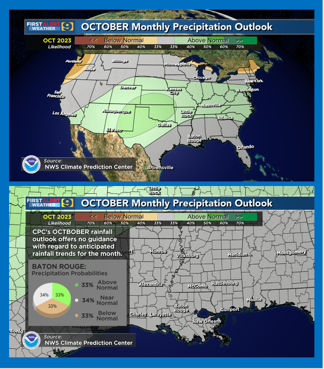
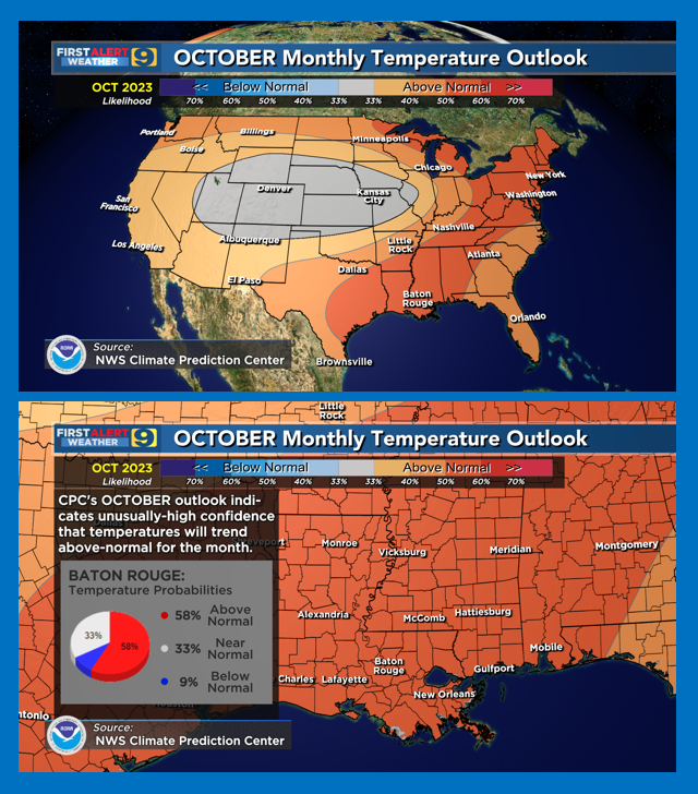
NWS/Climate Prediction Center October Outlooks:
(1) Louisiana monthly temps likely to average above-normal again
(2) no tendencies provided for monthly rainfall trends
(3) no significant improvements in the drought situation -- at least in the short term
#WAFBFirstAlert
FIRST ALERT Monday PM QuickCast
- 30% to 40% rain chances for each of the next 3 days
- dry-out by the weekend, staying dry deep into next week
- temps continue to run above-normal ... highs running 90° or more
- no drought relief any time soon
#WAFBFirstAlert
Last Seen Hashtags on Sotwe
jav onsen
Seen from Thailand
แอบถ่ายใต้กระโปรง
Seen from Japan
momson()*** +filter:native_video
Seen from United States
paypig
Seen from United States
鳩の嘘かホントか分からない話
Seen from United States
패드케어
Seen from United States
รับงานสายไหม
Seen from Thailand
creampie
Seen from United States
shemale public
Seen from Netherlands
体育生内裤
Trends for you
Most Popular Users

Elon Musk 
@elonmusk
240.6M followers

Barack Obama
@barackobama
119.2M followers

Donald J. Trump
@realdonaldtrump
111.7M followers

Cristiano Ronaldo
@cristiano
110.4M followers

Narendra Modi
@narendramodi
107M followers

Rihanna
@rihanna
97.6M followers

NASA
@nasa
92.2M followers

Justin Bieber
@justinbieber
90.9M followers

KATY PERRY
@katyperry
87.6M followers

Taylor Swift
@taylorswift13
81.4M followers

Lady Gaga
@ladygaga
72.9M followers

Virat Kohli
@imvkohli
69.8M followers

Kim Kardashian
@kimkardashian
69.7M followers

YouTube
@youtube
68.7M followers

Bill Gates
@billgates
63.8M followers

Neymar Jr
@neymarjr
62.5M followers

The Ellen Show
@theellenshow
62.4M followers

CNN
@cnn
61.9M followers

X
@x
60.8M followers

Selena Gomez
@selenagomez
60.7M followers