According to @FLASHWeatherAI for Aronimink, the wind will continue to whip this afternoon for the @PGAChampionship.
In fact, it won’t peak until around 6PM local with gusts topping out at 20-25MPH
Hard to put into words the presentation the ‘Snowicane’ will have on radar and satellite tomorrow morning…Incredible
Blizzard of ‘26 impacts for DE, Eastern MD, NJ, Philly, NYC Metro, LI, Southern New England and Boston:
-Widespread 1-2FT+ of Snow
-Hurricane Force Wind Gusts On The Coast. 40-50MPH Gusts Inland
-3-5FT of storm surge
Extreme Impacts.
That's as high as the scale goes. Gusts over 50 mph and well over a foot of snow means tens of millions will see a historic storm today through tomorrow night.
Blizzard Warnings are in effect for much of Coastal New Jersey, Metro NYC, Long Island, and Southern New England.
Amounts: 15-20” Locally 25”+
Winds: 55-60MPH+ Gusts
Preparations in these areas should be rushed to completion ahead of the onset of the storm tomorrow.
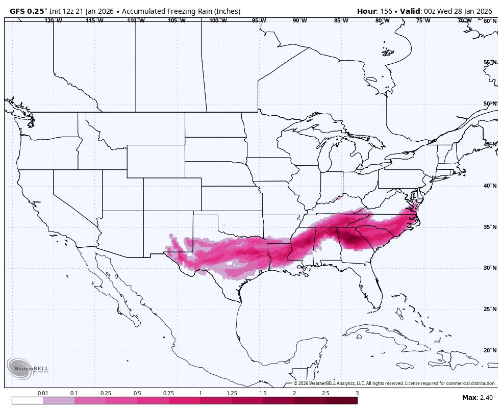
This weekend will feature a winter storm that millions of people will be talking about for some time.
50+ million people across the US will be impacted by heavy snow, heavy sleet, and crippling freezing rain.
Tune in to lead up and live coverage from the FLASH team the rest of the week.
As Tropical Storm #Melissa begins to organize today, some of the most reliable Hurricane and Global modeling are showing an incredibly dangerous scenario setting up for Jamaica.
It is becoming increasingly likely that Melissa will be a Category 4-5 hurricane late this weekend…
“It’s an honor to partner with the NAIA, its conferences, and schools. Together, we’ll help protect athletes, faculty, and fans while instilling confidence in weather-driven decision-making that enhances safety, optimizes operations, and supports agronomy.” -Steve Snedegar
We’re thrilled to welcome the NAIA as our newest partner and can't wait to see what the future holds together!
https://t.co/I9PzacxZtX
The tropics have finally come to life. First Gabrielle, and now Tropical Storm Humberto and potentially Imelda will need to be watched through the weekend and into next week as they approach the US East Coast.
Pictured below: FLASH’s in-app Global Extended 10 Day Radar.
Massive uptrend in the Euro and Euro AI guidance for this weekend into next week.
Everyone wanted a hurricane to track, well here’s 2 for you in the Western Atlantic. Buckle up.
Quite the forecast challenge is coming up for 93L and 94L…
Big players to consider:
-93L and 94L interaction
-Cutoff low in the Southeast US
-Strength of the ridge over the top of all features
-94L land interaction
Bahamas/US East Coast need to monitor over the next week…
FLASH Meteorologist Dave Downey is going live at 6 PM EST with live cameras and will be monitoring and providing updates on Hurricane Erin. Click here to join https://t.co/KcdsijvSzi
The incredible size of Hurricane #Erin is on display on the FlashCast Future Radar today.
You can use Flash’s Future Radar product and other valuable forecast products by downloading the FLASH AI app using the link below!
https://t.co/URkpUbx6RP
Hurricane Erin has incredibly intensified into a strong Category 4 storm this morning, potentially even nearing Category 5 strength as it passes just north of the Leeward Islands.
Mapping above is from our Weather Command Center and Mobile App.
-FlashCast future radar app view.
-6 hour AI Lightning Probability Forecast
-Excessive Rainfall Outlook provided by @NWSWPC
Command Center: https://t.co/ZrpoW0GKkD
Mobile App: https://t.co/URkpUbx6RP