Flood Factor® is now Risk Factor™!
Risk Factor™ makes it even easier to find your flood and wildfire risk.
Find your home’s Risk Factor™ now: https://t.co/DMsm7A91LH
#RiskFactor#climatechange
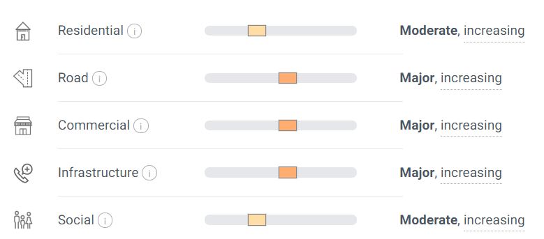
The new Community Risk section uses the First Street Foundation Flood Model to determine risk to communities from flooding. Findings show that 25% of America’s infrastructure and ~2 million miles of road are at risk.
See what’s at risk in your community https://t.co/Rb4492YRf2
https://t.co/Rb4492YRf2 defines the flood risk for every American – and that now includes risk to the broader social, commercial, and community infrastructure in your community.
Search now for what’s at risk in your community at https://t.co/Rb4492YRf2
If you're in the US watching the news about the flooding happening in Europe and wondering if similar 1,000-year-floodplain events are coming for you, I can't recommend @floodfactorcom enough. Free tool right at the cutting edge of flood modeling. https://t.co/lkebr4YilZ
13/ RT@mouthofmorrison
"If you're in the US watching the news about the flooding happening in Europe & wondering if similar 1,000-year-floodplain events are coming for you, I can't recommend @floodfactorcom enough. Free...cutting edge of flood modeling https://t.co/2mpjFyMkAy"
And finally, we’ve updated FEMA zones based on user-provided documentation, and improved statistics for 1,100 previously unavailable properties in Georgia.
https://t.co/nKPFMLtbk4 is continually improving and refining our flood models, incorporating the latest available data, and listening to feedback.
Latest updates 👇
Previous flood risk projections in the Dallas-Fort Worth metroplex area were using older elevation data.
Thanks to user feedback and help from local officials, we’ve incorporated new high-resolution LiDAR elevation data that improves flood risk projections in this area.
Curious about the flood risk to your property? Flood Factor is a free online tool created by the nonprofit First Street Foundation that makes it easy for Americans to find their property's risk of flooding. Check it out at https://t.co/qPkHT16Hep
How well do markets price information about climate risk? We study this question in the context of flood risk and the US real estate mkt, in a new paper led by the awesome Miyuki Hino (not on twitter). Paper plus short thread https://t.co/lm9QrPKCQF
April showers bring May flowers, but flooding doesn’t follow rules. #Climatechange means we need a plan ready for when disaster strikes. 🌊 🏡 Check out this tool to see your home’s flood risk now + in the future.
#FloodSafetyAwareness https://t.co/sCZQoJWpOD @FloodFactorCom
“The methodologies that the current insurance rates are based on… don’t really consider what’s going forward with climate change,” @FirstStreetFdn's @edward_j_kearns says. “We’re all waiting to see what kind of reform FEMA will bring, and we’re very supportive of that reform.”
🌊 Flood season is here and we want you to stay safe and protect your home as much as possible. @floodfactorcom is an excellent free resource to view your property’s risk and explore solutions for the future.
https://t.co/ipgo0Oznn2
Annual flood damage estimates are calculated based on a property’s flood risks, the likelihoods and depths of flooding projected for a building and building characteristics, such as property type, elevation, materials, building value.
Search now on https://t.co/3r4GxfYWjw
Flood Factor® makes it easy for anyone to find their property’s flood risk– and that now includes annual flood damage estimates for their homes.
Search now on https://t.co/3r4GxfYWjw
The annual flood damage cost estimates refer to how much, on average, a property-owner could expect to pay in repair costs from flood damage to their building in a given year.