Kenley was an ideal candidate to break the May daily minimum temperature record due to its elevation - at 170 m it sits above the temperature inversion, whilst many of its neighbouring sites below the inversion recorded lower temperatures overnight
https://t.co/459WXG8kVM
So there we were, driving across the Czech Republic on a big old road trip (end of April) ... and what do we see but a balloon! Ok, so it was near Brno, so maybe not so random. Anyone claim it? I think there was a meet on #Czech#balloon#Brno
After a record flight of 60 days, @WorldViewSpace Stratollite Dorado mission ended on April 26, 2026 in an undisclosed location in the Atlantic Ocean.
It broke the previous record for an Stratollite of 49 days aloft set in 2025 by Gryphon Retrofit
https://t.co/zfqK0Bh7uu
8 May 1944. Death of Albert Leo Stevens (b. 9 March 1877). American pioneering balloonist who also played a key role in the development of safety features for parachutes. He opened the first private airfield in the USA in 1909.
8 May 1980. Max Leroy Anderson and his son Kristian took off in their balloon 'Kitty Hawk' from Fort Baker, California for the first non-stop trans-North American balloon flight. The flight ended in Quebec on 12 May.
With just 3 weeks to go, we caught up with David Petters in his T6 Harvard, who will open the 2026 air display at 15:30 on Friday!
Tickets are rapidly running out, especially on Saturday, so get a wriggle on, get those tickets before it's too late! https://t.co/PpwQiNt6uJ
Our legendary NIGHTFIRE show will once again kick off the Midlands Air Festival on Friday 29th May.
This unique spectacular will feature a festival of air displays, mass hot air balloon lifts, pyrotechnic aircraft, night glow and a stunning firework finale display.
One of the challenges that makes mapping from Second World War unit war diaries particularly difficult is the mapping system itself, specifically the coordinate grids and map projections used at the time.
The British relied on several different map projection systems, each built on geodetic datums that were, by modern standards, imprecise. For northwest Europe, the two most relevant are Lambert Zone I, based on the Nouvelle Triangulation Française (NTF) datum and the Clarke 1880 ellipsoid, and Nord de Guerre, an older WWI-era grid based on the Ancienne Triangulation Française (ATF) datum and the Plessis 1817 ellipsoid. By 1944, Nord de Guerre was technically obsolete, but it still appeared as marginal reference ticks on many British-issued map sheets. These datums were derived from earlier triangulation surveys and predated the computational methods that would later allow for globally consistent, satellite-verified reference systems.
Geodesy as a discipline was still maturing, and without computers, producing and correcting large-scale surveys was slow, laborious work, made harder by the fact that a war was actively being fought. The practical consequence for a theatre like Normandy was that available map coverage relied on conical projections, specifically Lambert Conformal Conic, rather than the narrower strip-by-strip Transverse Mercator projection that underpins the modern Military Grid Reference System (MGRS). Transverse Mercator projections perform well over narrow north-south bands but distort rapidly as you move east or west. Lambert Conic projections handle wider east-west extents better, which is why they were preferred for covering broad operational theatres. The tradeoff is that both introduce distortion of different kinds depending on where you are on the sheet, and that distortion was baked into every map issued to every unit.
Layer on top of that the generalisation inherent in the most commonly available wartime maps, the GSGS 1:100,000 series. At that scale, features must be simplified: roads straightened, villages approximated, contours smoothed and errors compounded. In practice, positional inaccuracy across these sheets typically falls in the range of 100 to 200 metres, with worse outliers possible depending on the area and the source survey data. By modern standards that is significant. GPS-guided munitions rely on sub-metre accuracy, and calling close artillery fire with that margin of error would be genuinely hazardous to friendly troops. In the Second World War, those errors were real and unavoidable, and commanders and surveyors simply had to account for them operationally.
When we mapped Project '44, we manually georeferenced each GSGS map sheet and stitched them together, tying the sheets to known, identifiable features on the ground. Done carefully, this process keeps positional accuracy near the lower end of that 100 to 200 metre range, but it cannot push below it. The original datum and projection errors, the generalisation of the source maps, and the inevitable human error in the georeferencing process all combine in ways that cannot be fully eliminated. There is a floor, and that floor is set by the accuracy of the original surveys.
Over the last several days I have been working on a new approach to reduce that residual uncertainty and speed up the mapping workflow. It is a system of systems that brings together three reference layers in one interface.
The first is the wartime grid systems, specifically the coordinate grids actually used in the war diaries, enabling direct input and plotting of grid references as they appear in the source documents. The second is the georeferenced GSGS basemaps, the original wartime maps georeferenced to a modern coordinate system, so a plotted grid reference can be visually cross-checked against the map the unit itself would have been reading. The third is a modern accurate basemap, a contemporary mapping layer using current satellite-derived data, for ground truth comparison.
The idea is convergence across three independent references. Where all three agree, you have high confidence. Where they diverge, a human mapper can apply contextual judgment, drawing on terrain, road networks, and the unit narrative, to make the call on where the position actually was. The goal is faster, more efficient mapping without sacrificing interpretive rigour. Rather than automating the decision, the tool gives the mapper the best possible information to make an informed judgment about where a unit was and what they were doing.
Airship historian and brilliant artist Max Pinucci will be presenting a talk on the 1926 Arctic expedition of airship Norge at the Explorers Club in New York City on May 26, 2026. Well worth attending! A link to more information about the 100th anniversary in the comments.
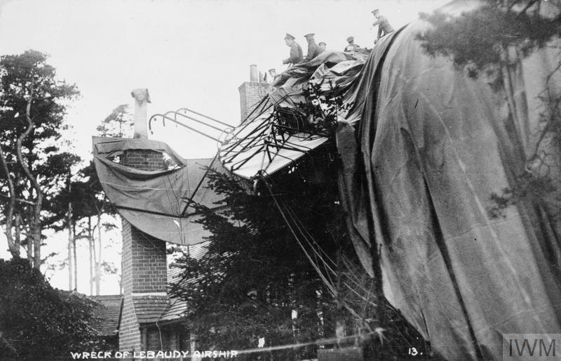
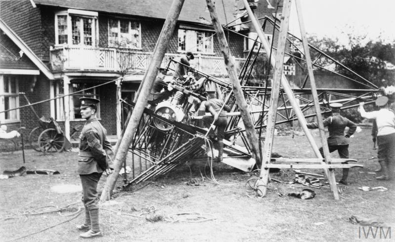
May 4 1911 At Farnborough, UK, the French Airship "Lebaudy Morning Post" crashes. It was a semi-rigid airship purchased by the British Army for the testing of lighter than air Aircraft. At the time it was the biggest Airship built in France.
https://t.co/0fXd8EF9Ee